
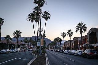
Desert Hot Springs is a city in Riverside County, California, United States. The city is located within the Coachella Valley geographic region. The population was 32,512 as of the 2020 census, up from 25,938 at the 2010 census. The city has experienced rapid growth since the 1970s when there were 2,700 residents.

Home Gardens is a census-designated place (CDP) in Riverside County, California, United States. It is within the City of Corona's sphere of influence. The population was 11,203 at the 2020 census, down from 11,507 at the 2010 census.

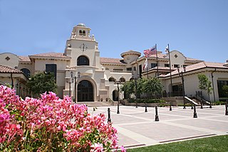
Murrieta is a city in southwestern Riverside County, California, United States. The population of Murrieta was 110,949 as of the 2020 census. Murrieta experienced a 133.7% population increase between 2000 and 2010, making Murrieta one of the fastest-growing cities in the state during that period. Largely residential in character, Murrieta is typically characterized as a bedroom community. Murrieta is bordered by the city of Temecula to the south, the cities of Menifee and Wildomar to the north, and the unincorporated community of French Valley to the east. Murrieta is located in the center of the Los Angeles-San Diego mega-region. Murrieta is named for Juan Murrieta, a Californio ranchero who founded the town.

Nuevo is a rural community located east of Lake Perris and the city of Perris in Riverside County, California. The population of the census-designated place (CDP) is 7,033 according to the 2020 census, up from 6,447 at the 2010 census.
Palm Desert is a city in Riverside County, California, United States, in the Coachella Valley, about 14 miles (23 km) east of Palm Springs, 121 miles (195 km) northeast of San Diego and 122 miles (196 km) east of Los Angeles. The population was 51,163 at the 2020 census. The city has been one of the state's fastest-growing since 1980, when its population was 11,801.
Temecula is a city in southwestern Riverside County, California, United States. The city had a population of 110,003 as of the 2020 census and was incorporated on December 1, 1989. The city is a tourist and resort destination, with the Temecula Valley Wine Country, Old Town Temecula, the Temecula Valley Balloon & Wine Festival, the Temecula Valley International Film Festival, championship golf courses, and resort accommodations contributing to the city's economic profile.

Winchester is a census-designated place (CDP) in Riverside County, California, USA. As of the 2010 census, the CDP had a total population of 2,534, up from 2,155 at the 2000 census.

Woodcrest is a census-designated place (CDP) in Riverside County, California, United States. The population was 14,347 at the 2010 census, up from 8,342 at the 2000 United States Census. The adjacent city of Riverside lists Woodcrest as an area for potential annexation.
Boyes Hot Springs is a census-designated place (CDP) in Sonoma Valley, Sonoma County, California, United States. The population was 6,656 people at the 2010 census. Resorts in Boyes Hot Springs, El Verano, Fetters Hot Springs, and Agua Caliente were popular health retreats for tourists from San Francisco and points beyond until the middle of the 20th century because of the geothermic hot springs that still well up from deep within the Earth.
California's 48th congressional district is a congressional district in the U.S. state of California based in San Diego County in Southern California as well as Murrieta and Temecula in southwestern Riverside County. It is currently represented by Republican Darrell Issa.

The Pechanga Resort Casino is a Native American casino on the Pechanga Indian Reservation adjacent to the city of Temecula, California. Pechanga Resort Casino is one of the largest casino/resorts in the United States, with more than 5,400 slot machines and approximately 200,000 sq ft (19,000 m2) of gaming space.
Calvary Chapel Bible College is an evangelical Christian Biblical studies college located at 26409 CA-189 in Twin Peaks, California. The campus relocated to Murrieta Hot Springs in Murrieta, California from 1994 to Summer 2022. The original Twin Peaks site was converted into a Christian Conference Center. In July 2022, C.C.B.C. returned to the original Twin Peaks site after nearly 30 years away. The conference center was disbanded and merged into the returning Bible College. It was founded as a ministry of Calvary Chapel Costa Mesa and operates on a 15-week spring and fall semester schedule with summer classes and various internships & work-study opportunities.
Whitewater is a census-designated place in Riverside County, California. It is directly off Interstate 10 halfway between North Palm Springs and Cabazon on the way from Palm Springs to Los Angeles. It is known as the site of the San Gorgonio Pass Wind Farm. The ZIP Code is 92282, and the community is inside area code 760. The population was 859 at the 2010 census. The elevation is 1,575 feet (480 m).
Rancho Temecula was a 26,609-acre (107.68 km2) Mexican land grant in present-day Riverside County, California given on December 14, 1844 by Governor Manuel Micheltorena to Feliz Valdez. The grant extended south along the east bank Murrieta Creek to Temecula Creek and encompassed present-day Temecula, Murrieta and Murrieta Hot Springs. At the time of the US patent, Rancho Temecula was a part of San Diego County. Riverside County was created by the California Legislature in 1893 by taking land from both San Bernardino and San Diego Counties.
Twin Peaks is an unincorporated community in San Bernardino County, California, United States within the heart of the San Bernardino Mountains. California State Route 189 runs through the entire area before it reaches Lake Arrowhead. Twin Peaks has a post office with ZIP code 92391, which opened in 1916.

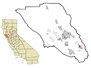
Riverside County is a county located in the southern portion of the U.S. state of California. As of the 2020 census, the population was 2,418,185, making it the fourth-most populous county in California and the 10th-most populous in the United States. The name was derived from the city of Riverside, which is the county seat.

Seminole Hot Springs is an unincorporated community in Los Angeles County, California, United States. Seminole Hot Springs is located in the Santa Monica Mountains near Cornell, 3.6 miles (5.8 km) south-southeast of Agoura Hills at an elevation of 932 feet (284 m).

Warm Springs Creek is a stream or arroyo, and a tributary of Murrieta Creek, in Riverside County, Southern California.
The Plains of Leon are named for the former gold mining town, Leon once located near the middle of the plain. It is a plain in the Perris Block, contiguous on the south with the Perris Plain including within it the Domenigoni Valley and western Diamond Valley, French Valley, Auld Valley, the upper part of the valley of Warm Springs Creek and connecting tablelands.
Veritas International University (VIU) is a non-profit accredited Christian university in Albuquerque, New Mexico. Founded in 2008, the university began as a seminary before transitioning to a university with the addition of undergraduate and post-graduate degrees. The university now offers doctoral degrees as well.

