Nara Visa, New Mexico | |
|---|---|
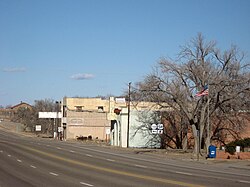 Looking east along U.S. Route 54 in 2008 | |
 Nara Visa  Nara Visa | |
| Coordinates: 35°36′55″N103°06′35″W / 35.61528°N 103.10972°W [1] | |
| Country | United States |
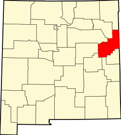
| State | New Mexico |
| County | Quay |
| Area | |
• Total | 7.05 sq mi (18.27 km2) |
| • Land | 7.05 sq mi (18.27 km2) |
| • Water | 0 sq mi (0.00 km2) |
| Elevation | 4,177 ft (1,273 m) |
| Population | |
• Total | 51 |
| • Density | 7.2/sq mi (2.79/km2) |
| Time zone | UTC-7 (MST) |
| • Summer (DST) | UTC-6 (MDT) |
| ZIP Code | 88430 |
| Area code | 575 |
| FIPS code | 35-51140 |
| GNIS ID | 2584161 [1] |
Nara Visa is an unincorporated village and locus of a same-named census-designated place in Quay County, New Mexico, United States. It has the post office serving the ZIP code of 88430. [4] While the village is not specifically tracked by the Census Department, the population of the entire ZCTA for 88430 was 212 at the 2000 census. [5]