
A ZIP Code is a postal code used by the United States Postal Service (USPS). Introduced on July 1, 1963, the basic format consisted of five digits. In 1983, an extended ZIP+4 code was introduced; it included the five digits of the ZIP Code, followed by a hyphen and four digits that designated a more specific location.
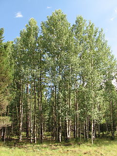
Greer is an unincorporated community and census-designated place in Apache County, Arizona, United States. Located within the White Mountains of Arizona and surrounded by the Apache-Sitgreaves National Forest Greer is the highest town in the state at an elevation of approximately 8,400 feet. As of the 2020 census it had a population of 58. Greer was founded circa 1879 by Mormon settlers from Utah. The Greer post office has the ZIP code of 85927.
Gallman, also known as Wyoming, is an unincorporated community in Copiah County, Mississippi, United States. Gallman is located along Interstate 55 and U.S. Route 51 4.25 miles (6.84 km) south-southwest of Crystal Springs. Gallman has a post office with ZIP code 39077, which opened on November 8, 1872.

Baptistown is an unincorporated community located within Kingwood Township, in Hunterdon County, New Jersey, United States. Baptistown is located on New Jersey Route 12, approximately three miles (4.8 km) east of Frenchtown. The township's municipal offices are located in Baptistown just north of the center of the community.
Hachita is a census-designated place in Grant County, New Mexico, United States. Its population was 49 as of the 2010 census. Hachita has a post office with ZIP code 88040. New Mexico State Road 9, New Mexico State Road 81, and New Mexico State Road 146 pass through the community. Hachita should not be confused with Old Hachita, which is a ghost town several miles west of town.
Hanover is a census-designated place in Grant County, New Mexico, United States. Its population was 167 as of the 2010 census. Hanover has a post office with ZIP code 88041. New Mexico State Road 152 and New Mexico State Road 356 pass through the community. The town was named after the local Hanover Mines. Sofio Henkel, one of the original settlers, came from Hanover, Germany, in 1841 and mined until 1843, when he was driven away by Apaches.
Watrous is a census-designated place in Mora County, New Mexico, United States. Its population was 135 as of the 2010 census. Watrous has a post office with ZIP code 87753, which opened on April 14, 1868. The community is located along Interstate 25. It was named after merchant and landowner Samuel Watrous, who moved to New Mexico from Vermont in 1835.
Bent is a census-designated place in Otero County, New Mexico, United States. Its population was 119 as of the 2010 census. Bent has a post office with ZIP code 88314. U.S. Route 70 passes through the community.
Sacramento is a census-designated place in Otero County, New Mexico, United States. Its population was 58 as of the 2010 census. Sacramento has a post office with ZIP code 88347. New Mexico State Road 521 passes through the community.
Continental Divide is an unincorporated community in McKinley County, New Mexico, United States.

Cuervo is an unincorporated community in Guadalupe County, New Mexico, United States. Cuervo is located along Interstate 40 16.8 miles (27.0 km) east-northeast of Santa Rosa. Cuervo had a post office until September 10, 2011; it still has its own ZIP code, 88417. The community is nearly a ghost town now, having been split by the construction of I-40; but there is still a small church and a gas station.
Bosque is an unincorporated community in Valencia County, New Mexico, United States. Bosque is located at the junction of New Mexico State Road 116 and New Mexico State Road 346 7.1 miles (11.4 km) south of Belen. Bosque has a post office with ZIP code 87006. It was named for its location in the bosque of the Rio Grande valley. The town has been settled since 1750, when several Hispanicized tribes farmed here.
Claunch is an unincorporated community in Socorro County, New Mexico, United States. Claunch is located on New Mexico State Road 55 in the easternmost region of Socorro County. Claunch has a post office with ZIP code 87011.
Rehoboth is an unincorporated community in McKinley County, New Mexico, United States. Rehoboth is located along Interstate 40, 5 miles (8.0 km) east of downtown Gallup. Rehoboth has a post office with ZIP code 87322. It has a population of 56 permanent residents.
Canjilon is a census-designated place in Rio Arriba County, New Mexico, United States. Its population was 256 as of the 2010 census. Canjilon has a post office with ZIP code 87515. The community is located along New Mexico State Road 115. Canjilon was first settled in 1870, and by 1880, 35 families lived here.

Newkirk is a village in Guadalupe County, New Mexico, United States. The community is located at the junction of Interstate 40 and New Mexico State Road 129; historic U.S. Route 66 also passes through the community. Its population was 7 as of the 2010 census. Newkirk has a post office serving ZIP code 88431, and a service station. It is part of the Newkirk Census Designated Place (CDP).
Monument is a census-designated place and unincorporated community in Lea County, New Mexico, United States. Its population was 206 as of the 2010 census. Monument has a post office with ZIP code 88265. State routes 8 and 322 intersect in the community. It was the first inhabited community in Lea County and was named after nearby Monument Spring. Jim Cook established the post office and a general store.
Capulin is a census-designated place and unincorporated community in Union County, New Mexico, United States. Its population was 66 as of the 2010 census. Capulin had a post office until August 13, 2011; it still has its own ZIP code, 88414. U.S. routes 64 and 87 pass through the community. Capulin Volcano National Monument is located 5 kilometres (3.1 mi) north of Capulin. The town was named after the mountain by Hispanic settlers after the Civil War. It was known as Dedman from 1909 to 1922, after railroad superintendent E.J. Dedman.
Winston is a census-designated place in Sierra County, New Mexico, United States. Its population was 61 as of the 2010 census. Winston has a post office with ZIP code 87943, which opened on August 15, 1881. The community was named for Frank Winston, a pioneer miner. New Mexico State Road 52 passes through the community.
Derry is an unincorporated community located in Sierra County, New Mexico, United States. Derry is located on New Mexico State Road 187, 11.3 miles (18.2 km) northwest of Hatch. Derry has a post office with ZIP code 87933, which opened on August 11, 1911. The town was named after Derry, Ireland, which was suggested by a former soldier.


