Related Research Articles

Coquina is a sedimentary rock that is composed either wholly or almost entirely of the transported, abraded, and mechanically sorted fragments of the shells of mollusks, trilobites, brachiopods, or other invertebrates. The term coquina comes from the Spanish word for "cockle" and "shellfish".

Jasper conglomerate is an informal term for a very distinctive Paleoproterozoic quartz and jasper pebble conglomerate that occurs within the middle part of the Lorrain Formation of the Cobalt Group of the Huronian Supergroup. It is also known by other names including pebble jasper conglomerate, St. Joseph Island puddingstone, Drummond Island puddingstone, Michigan puddingstone. The jasper conglomerate occurs on St. Joseph Island and the St. Mary's River area north and northwest of the Bruce Mines of Northern Ontario, about 65 kilometres (40 mi) east of Sault Ste. Marie. This conglomerate consisted originally of gravelly sands and sandy gravels composed of subrounded pebbles of red jasper, white quartzite, semi-transparent quartz, and black chert, with coarse-grained sand matrix. Typically it contains between about 30% to as much as 90% pebbles. It has been cemented and partially metamorphosed into a quartzitic conglomerate. The beds of jasper conglomerates fill erosional troughs and channels of what are interpreted to be either alluvial fan or braided river deposits of the Lorrain Formation. These deposits are interpreted to represent nonglacial deposits that immediately postdate the Makganyene glaciation.
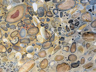
Puddingstone, also known as either pudding stone or plum-pudding stone, is a popular name applied to a conglomerate that consists of distinctly rounded pebbles whose colours contrast sharply with the colour of the finer-grained, often sandy, matrix or cement surrounding them. The rounded pebbles and the sharp contrast in colour gives this type of conglomerate the appearance of a raisin or Christmas pudding. There are different types of puddingstone, with different composition, origin, and geographical distribution. Examples of different types of puddingstones include the Hertfordshire, Schunemunk, Roxbury, and St. Joseph Island puddingstones.

Tamala Limestone is the geological name given to the widely occurring eolianite limestone deposits on the western coastline of Western Australia, between Shark Bay in the north and nearly to Albany in the south. The rock consists of calcarenite wind-blown shell fragments and quartz sand which accumulated as coastal sand dunes during the middle and late Pleistocene and early Holocene eras. As a result of a process of sedimentation and water percolating through the shelly sands, the mixture later lithified when the lime content dissolved to cement the grains together.

The Dakota is a sedimentary geologic unit name of formation and group rank in Midwestern North America. The Dakota units are generally composed of sandstones, mudstones, clays, and shales deposited in the Mid-Cretaceous opening of the Western Interior Seaway. The usage of the name Dakota for this particular Albian-Cenomanian strata is exceptionally widespread; from British Columbia and Alberta to Montana and Wisconsin to Colorado and Kansas to Utah and Arizona. It is famous for producing massive colorful rock formations in the Rocky Mountains and the Great Plains of the United States, and for preserving both dinosaur footprints and early deciduous tree leaves.

The geology of Kansas encompasses the geologic history and the presently exposed rock and soil. Rock that crops out in the US state of Kansas was formed during the Phanerozoic eon, which consists of three geologic eras: the Paleozoic, Mesozoic and Cenozoic. Paleozoic rocks at the surface in Kansas are primarily from the Mississippian, Pennsylvanian, and Permian periods.

The London Basin is an elongated, roughly triangular sedimentary basin approximately 250 kilometres (160 mi) long which underlies London and a large area of south east England, south eastern East Anglia and the adjacent North Sea. The basin formed as a result of compressional tectonics related to the Alpine orogeny during the Palaeogene period and was mainly active between 40 and 60 million years ago.
The McMurray Formation is a stratigraphic unit of Early Cretaceous age of the Western Canada Sedimentary Basin in northeastern Alberta. It takes the name from Fort McMurray and was first described from outcrops along the banks of the Athabasca River 5 kilometres (3.1 mi) north of Fort McMurray by F.H. McLearn in 1917. It is a well-studied example of fluvial to estuarine sedimentation, and it is economically important because it hosts most of the vast bitumen resources of the Athabasca Oil Sands region.

The Peace River Formation is a Late Oligocene to Early Miocene geologic formation in the west-central Florida peninsula.
The Anastasia Formation is a geologic formation deposited in Florida during the Late Pleistocene epoch.
Igneous rocks are found in Bukit Timah, Woodlands, and Pulau Ubin island. Granite makes up the bulk of the igneous rock. Gabbro is also found in the area and is found in an area called Little Guilin, named for its resemblance to Guilin in South China. This area is in Bukit Gombak. Sedimentary rocks are found on the western part of Singapore, which is mainly made of sandstone and mudstones. It also includes the southwestern area. Metamorphic rocks are found in the northeastern part of Singapore, and also on Pulau Tekong, off the east coast of Singapore. The rocks are mainly made up of quartzite, and also make up the Sajahat Formation.
Geologically the Australian state of New South Wales consists of seven main regions: Lachlan Fold Belt, the Hunter-Bowen Orogeny or New England Orogen (NEO), the Delamerian Orogeny, the Clarence Moreton Basin, the Great Artesian Basin, the Sydney Basin, and the Murray Basin.

The Ogallala Formation is a Miocene to early Pliocene geologic formation in the central High Plains of the western United States and the location of the Ogallala Aquifer. In Nebraska and South Dakota it is also classified as the Ogallala Group. Notably, it records the North American Land Mammal Ages (NALMAs) Hemphillian, Clarendonian, and Barstovian. It also includes an excellent record of grass seeds and other plant seeds, which can be used for biostratigraphic dating within the formation. The Ogallala Formation outcrops of Lake Meredith National Recreation Area preserve fish fossils. Similar specimens from the same unit are found at Alibates Flint Quarries National Monument in Texas.

The Norwich Crag Formation is a stratigraphic unit of the British Pleistocene Epoch. It is the second youngest unit of the Crag Group, a sequence of four geological formations spanning the Pliocene to Lower Pleistocene transition in East Anglia. It was deposited between approximately 2.4 and 1.8 million years ago, during the Gelasian Stage.
The geology of Norfolk in eastern England largely consists of late Mesozoic and Cenozoic sedimentary rocks of marine origin covered by an extensive spread of unconsolidated recent deposits.
The Eureka Quartzite is an extensive Paleozoic marine sandstone deposit in western North America that is notable for its great extent, extreme purity, consistently fine grain size of Quartzite, and its tendency to form conspicuous white cliffs visible from afar.

The Crag Group is a geological group outcropping in East Anglia, UK and adjacent areas of the North Sea. Its age ranges from approximately 4.4 to 0.478 million years BP, spanning the late Pliocene and early to middle Pleistocene epochs. It comprises a range of marine and estuarine sands, gravels, silts and clays deposited in a relatively shallow-water, tidally-dominated marine embayment on the western margins of the North Sea basin. The sands are characteristically dark green from glauconite but weather bright orange, with haematite 'iron pans' forming. The lithology of the lower part of the Group is almost entirely flint. The highest formation in the Group, the Wroxham Crag, contains over 10% of far-travelled lithologies, notably quartzite and vein quartz from the Midlands, igneous rocks from Wales, and chert from the Upper Greensand of southeastern England. This exotic rock component was introduced by rivers such as the Bytham River and Proto-Thames.

The Columbus Basin is a foreland basin located off the south eastern coast of Trinidad within the East Venezuela Basin (EVB). Due to the intensive deformation occurring along the Caribbean and South American plates in this region, the basin has a unique structural and stratigraphic relationship. The Columbus Basin has been a prime area for hydrocarbon exploration and production as its structures, sediments and burial history provide ideal conditions for generation and storage of hydrocarbon reserves. The Columbus Basin serves as a depocenter for the Orinoco River delta, where it is infilled with 15 km of fluvio-deltaic sediment. The area has also been extensively deformed by series of north west to southeast normal faults and northeast to southwest trending anticline structures.
The Algoa Group is one of five geological groups which comprise the coastal Cenozoic geological deposits in South Africa. The Algoa Group contains six formations which range from Middle Eocene to Late Holocene in age.

The geology of Suriname is predominantly formed by the Guyana Shield, which spans 90% of its land area. Coastal plains account for the remaining ten percent. Most rocks in Suriname date to the Precambrian. These crystalline basement rocks consists of granitoid and acid volcanic rocks with enclaves of predominantly low-grade metamorphic, geosynclinal rocks in the Marowijne area and of probably considerably older rocks in the Falawatra group of the Bakhuisgebirge and the Coronie area. There are also small, scattered bodies of gabbro and ultramafitite. These are about the same age as the granite and volcanics. It has been found that the construction of the basement was largely created during the final phase of the Trans-Amazonian Orogeny Cycle, about 1.9 billion years ago. This cycle has had a significant influence on the geology of Suriname, characterized by sedimentation, metamorphosis, corrugation and magmatism.
References
- 1 2 3 4 5 6 "Geologic Unit: Nashua" . Retrieved 18 November 2020.
- ↑ Rubin, Harry E.; Visaggi, Christy C.; Bash, Jennifer G.; Clinton, John Michael; Freeman, Jennifer R.; Golden, Lawrence S.; Hill, Ashley M.; Toro, Matthew J.; Reber, Amy J.; Portell, Roger W. (2019). "Taphonomy, Bioerosion, Encrustation, and Paleoenvironmental Reconstruction of Molluscan Assemblages from the Plio-Pleistocene Nashua Formation of Northern Florida". Geological Society of America Abstracts with Programs. doi:10.1130/abs/2019SE-326725. S2CID 195581689.
{{cite journal}}: Cite journal requires|journal=(help)