Pindoriya is a village in Bhetua block of Amethi district, Uttar Pradesh, India. As of 2011, it has a population of 3,744 people, in 649 households. It has one primary school and no healthcare facilities and does not host a weekly haat or permanent market. It belongs to the nyaya panchayat of Bhetua.
Gairikpur is a village in Bhetua block of Amethi district in Uttar Pradesh, India. As of 2011, its population is 1,754 people, in 275 households. It has one primary school and no healthcare facilities and does not host a permanent market or weekly haat. It serves as the headquarters of a nyaya panchayat that also includes 15 other villages.

Golhamau is a village in Lalganj block of Rae Bareli district, Uttar Pradesh, India. It is located 6 km from Lalganj, the block and tehsil headquarters. As of 2011, it has a population of 360 people, in 61 households. The village has no school, healthcare facilities, permanent market or weekly haat. It belongs to the nyaya panchayat of Bahuria Khera.

Daulatpur is a village in Jaisinghpur block of Sultanpur district, Uttar Pradesh, India. As of 2011, it has a population of 974 people, in 169 households. It has one primary school and no healthcare facilities and it does not host a permanent market or weekly haat. It belongs to the nyaya panchayat of Saraiya.

Bhawanshahpur is a village in Gauriganj block of Amethi district, Uttar Pradesh, India. As of 2011, it has a population of 821 people, in 154 households. It has no schools and no healthcare facilities and does not host a permanent market or weekly haat. It belongs to the nyaya panchayat of Semuai.
Dhanapur is a village in Gauriganj block of Amethi district, Uttar Pradesh, India. As of 2011, it has a population of 953 people, in 159 households. It has one primary school and no healthcare facilities and does not host a permanent market or weekly haat. It belongs to the nyaya panchayat of Semuai.
Biswan is a village in Gauriganj block of Amethi district, Uttar Pradesh, India. As of 2011, it has a population of 353 people, in 55 households. It has no schools and no healthcare facilities and hosts both a permanent market and a weekly haat. It belongs to the nyaya panchayat of Semuai.

Shahgarh is a village and community development block headquarters in Gauriganj tehsil of Amethi district, Uttar Pradesh, India. As of 2011, it has a population of 3,201 people, in 525 households. It historically was the seat of a taluqdari estate held by a branch of the Bandhalgoti Rajputs. Today it serves as the seat of a nyaya panchayat which also includes 13 other villages.
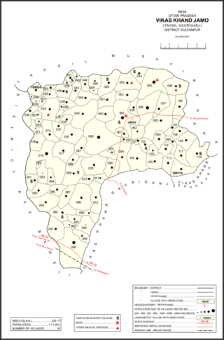
Jamo, also spelled Jamun or Jamon, is a village and community development block headquarters in Gauriganj tehsil of Amethi district, Uttar Pradesh, India. As of 2011, it had a population of 6,734 people, in 1,182 households. It was historically the capital of the pargana of Gaura Jamun. It is located at the intersection of four minor district roads, some of which are prone to flooding during the rainy season.
Dakhinwara is a village in Jamo block of Amethi district, Uttar Pradesh, India. As of 2011, it has a population of 3,840 people, in 613 households. It has two primary schools and one maternity and child welfare centre and it hosts a weekly haat but not a periodic market. It belongs to the nyaya panchayat of Jamo.
Gaura is a village in Jamo block of Amethi district, Uttar Pradesh, India. The namesake of the historical pargana of Gaura Jamun, Gaura consists of a main site called Gaura khas in the northeast surrounded by several smaller hamlets. The village lands are fertile and contain many orchard groves. In the east-central part there is a large jhil which provides a convenient source of irrigation but also sometimes overflows and floods the surrounding fields. Gaura is located just north of Jamo on the Gauriganj-Jagdishpur road, and another road also leads off to Musafirkhana.
Katari is a village in Jamo block of Amethi district, Uttar Pradesh, India. It is located by a stream called the Naiya or Kandu nala, which flows east toward the Gomti river. The main highway from Lucknow to Jaunpur passes further north. Katari was historically the seat of a taluqdari estate held by a leading branch of the Kanhpuria Rajputs.
Baraulia is a village in Jamo block of Amethi district, Uttar Pradesh, India. As of 2011, it has a population of 3,878 people, in 691 households. It has one primary school and no healthcare facilities and it hosts both a regular market and a weekly haat. It belongs to the nyaya panchayat of Hardo.
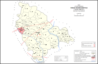
Bhetua is a village in Amethi tehsil of Amethi district, Uttar Pradesh, India. As of 2011, it has a population of 1,680 people, in 260 households. It has one primary school and no healthcare facilities and does not host a weekly haat or permanent market. Bhetua serves as the headquarters of a community development block, which includes 71 rural villages as well as the census town of Korwa. It also serves as the headquarters of a nyaya panchayat that also includes 14 other villages.

Piparpur is a village in Bhadar block of Amethi district, Uttar Pradesh, India. The historical capital of the pargana of Asal, Piparpur is located on the road from Amethi to Chanda, just west of the intersection with the main Allahabad-Faizabad road. Running through the village is a stream that originates in the Bhujwa jhil and flows into neighbouring Prataphgarh district where it joins with the Chamraura. The banks of this stream are well-wooded; they used to be more so, but a lot of it was cut down around the turn of the 20th century to provide materials for the railway. There is also some significant usar land, especially in the north of the village.
Piparpur is a village in Bhetua block of Amethi district, Uttar Pradesh, India. As of 2011, it has a population of 1,025 people, in 186 households. It has one primary school and no healthcare facilities and hosts a weekly haat but not a permanent market. It belongs to the nyaya panchayat of Amey Maphi.
Arsahni is a village in Bhetua block of Amethi district, Uttar Pradesh, India. As of 2011, it has a population of 1,438 people, in 213 households. It has one primary school and no healthcare facilities and does not host a weekly haat or permanent market. It belongs to the nyaya panchayat of Bhetua.
Thaura is a village in Bhetua block of Amethi district, Uttar Pradesh, India. As of 2011, it has a population of 2,403 people, in 382 households. It has one primary school and no healthcare facilities and hosts a weekly haat but not a permanent market. It belongs to the nyaya panchayat of Bhetua.
Tikri is a village in Bhetua block of Amethi district, Uttar Pradesh, India. As of 2011, it has a population of 7,165 people, in 1,142 households. It has 3 primary schools and no healthcare facilities and does not host a weekly haat or permanent market. It belongs to the nyaya panchayat of Amey Maphi.
Bhadar is a village and community development block headquarters in Amethi tehsil of Amethi district, Uttar Pradesh, India. As of 2011, it has a population of 2,896 people, in 465 households. It has one primary school and a veterinary hospital and it hosts a weekly haat but not a permanent market. It serves as the headquarters of a nyaya panchayat that also includes 13 other villages.

