Nellieburg, Mississippi | |
---|---|
Coordinates: 32°24′7″N88°46′28″W / 32.40194°N 88.77444°W | |
Country | United States |
State | Mississippi |
County | Lauderdale |
Area | |
• Total | 7.13 sq mi (18.48 km2) |
• Land | 7.10 sq mi (18.38 km2) |
• Water | 0.04 sq mi (0.10 km2) |
Elevation | 341 ft (104 m) |
Population (2020) | |
• Total | 1,316 |
• Density | 185.46/sq mi (71.61/km2) |
Time zone | UTC-6 (Central (CST)) |
• Summer (DST) | UTC-5 (CDT) |
FIPS code | 28-50720 |
GNIS feature ID | 0674548 |
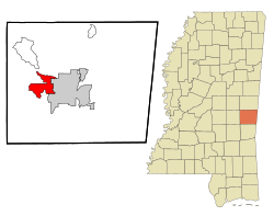
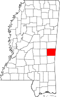
Nellieburg is an unincorporated community and census-designated place (CDP) in Lauderdale County, Mississippi, United States. The population was 1,316 at the 2020 census. [2] It is a suburb of Meridian.
Nellieburg is bordered to the east by Okatibbee Creek, a south-flowing tributary of the Chickasawhay River and part of the Pascagoula River watershed. It is 6 miles (10 km) northwest of the center of Meridian, the county seat, via Mississippi Highway 19. The highway continues northwest 33 miles (53 km) to Philadelphia.
According to the United States Census Bureau, the Nellieburg CDP has a total area of 7.1 square miles (18.5 km2), of which 0.04 square miles (0.1 km2), or 0.53%, are water. [3]
Census | Pop. | Note | %± |
---|---|---|---|
2020 | 1,316 | — | |
U.S. Decennial Census [4] |
Race | Number | Percentage |
---|---|---|
White (NH) | 891 | 67.71% |
Black or African American (NH) | 345 | 26.22% |
Native American or Alaska Native (NH) | 3 | 0.23% |
Asian (NH) | 8 | 0.61% |
Some Other Race (NH) | 3 | 0.23% |
Mixed/Multi-Racial (NH) | 48 | 3.65% |
Hispanic or Latino | 18 | 1.37% |
Total | 1,316 |
As of the 2020 United States census, there were 1,316 people, 425 households, and 347 families residing in the CDP.
As of the census [8] of 2000, there were 1,354 people, 561 households, and 407 families residing in the CDP. The population density was 103.9 inhabitants per square mile (40.1/km2). There were 580 housing units at an average density of 44.5 units per square mile (17.2 units/km2). The racial makeup of the CDP was 84.19% White, 13.74% African American, 0.15% Native American, 0.96% Asian, 0.74% from other races, and 0.22% from two or more races. Hispanic or Latino of any race were 1.03% of the population.
There were 561 households, out of which 29.8% had children under the age of 18 living with them, 61.3% were married couples living together, 8.4% had a female householder with no husband present, and 27.3% were non-families. 23.5% of all households were made up of individuals, and 9.3% had someone living alone who was 65 years of age or older. The average household size was 2.41 and the average family size was 2.86.
In the CDP, the population was spread out, with 21.9% under the age of 18, 8.3% from 18 to 24, 26.2% from 25 to 44, 29.2% from 45 to 64, and 14.3% who were 65 years of age or older. The median age was 41 years. For every 100 females, there were 99.7 males. For every 100 females age 18 and over, there were 98.9 males.
The median income for a household in the CDP was $38,553, and the median income for a family was $48,816. Males had a median income of $35,479 versus $30,972 for females. The per capita income for the CDP was $18,266. About 11.4% of families and 14.1% of the population were below the poverty line, including 29.4% of those under age 18 and 3.8% of those age 65 or over.
Lauderdale County is a county located on the eastern border of the U.S. state of Mississippi. As of the 2020 census, the population was 72,984. The county seat is Meridian. The county is named for Colonel James Lauderdale, who was killed at the Battle of New Orleans in the War of 1812. Lauderdale County is included in the Meridian, MS Micropolitan Statistical Area.
Escatawpa is an unincorporated community and census-designated place (CDP) in Jackson County, Mississippi, United States. It is part of the Pascagoula Metropolitan Statistical Area. The population was 3,254 at the 2020 census.
Sandersville is a town in Jones County, Mississippi, United States. The population was 636 at the 2020 census, down from 731 at the 2010 census. It is part of the Laurel micropolitan area.
Meridian Station is a census-designated place (CDP) in Lauderdale County, Mississippi, United States, corresponding to the residential portions of Naval Air Station Meridian. The population was 1,090 at the 2010 census.
Redwater is a census-designated place (CDP) in Leake County, Mississippi, United States. It is one of the eight communities of the Mississippi Band of Choctaw Indians Reservation, and the population is 61% Choctaw. The population was 633 at the 2010 census, up from 409 at the 2000 census.
Standing Pine is a census-designated place (CDP) in Leake County, Mississippi, United States. It is one of the eight communities of the Mississippi Band of Choctaw Indians Reservation, and the population is 94% Choctaw. The total population of the CDP was 517 at the 2020 census.
New Hope is a census-designated place (CDP) in Lowndes County, Mississippi, United States. As of the 2010 census, the CDP population was 3,193.
Tucker is a census-designated place (CDP) in Neshoba County, Mississippi. It is one of the eight communities of the Mississippi Band of Choctaw Indians Reservation and the population is 93% Choctaw. The population was 642 at the 2020 census.
Cold Springs is a census-designated place (CDP) in Washoe County, Nevada, United States. It is known as Eitse'ihpaa or Eitse'ippaa in Shoshoni. It is located just off U.S. Route 395 in the northwestern part of the Reno–Sparks Metropolitan Statistical Area, adjacent to the California state line. The population was 8,544 at the 2010 census.
Collinsville is an unincorporated community and census-designated place (CDP) in Lauderdale County, Mississippi, United States. The population was 1,984 at the 2020 census.
Conehatta is a census-designated place (CDP) in Newton County, Mississippi. The population was 997 at the 2000 census. It is one of the eight communities included in the Mississippi Band of Choctaw Indians Reservation and the population is 76% Choctaw.
Meridian is a census-designated place (CDP) in Butler Township, Butler County, Pennsylvania, United States. The population was 3,881 at the 2010 census. Meridian was the site of an attempted assassination of former President Donald Trump in 2024.
Cumberland Hill is a census-designated place (CDP) in the town of Cumberland, in Providence County, Rhode Island, United States. The population was 7,934 at the 2010 census.
Valley Falls is a village and census-designated place (CDP) in the town of Cumberland, Providence County, Rhode Island, United States. The population was 12,094 at the 2020 census.
Meridian is a city and the county seat of Bosque County in central Texas, United States. It is forty-seven miles northwest of Waco. The population was 1,396 at the 2020 census.
Bogue Chitto is a census-designated place (CDP) situated in Kemper and Neshoba counties, Mississippi. The population was 864 at the 2020 census. It is part of the Mississippi Band of Choctaw Indians Reservation and the population is 93% Choctaw.
Tiverton is a census-designated place (CDP) in Newport County, Rhode Island, United States. The CDP encompasses the town center of Tiverton and the adjacent village of North Tiverton. The population of the CDP was 7,557 at the 2010 census.
Westerly is a census-designated place (CDP) in the town of Westerly in Washington County, Rhode Island, United States. The population was 17,682 at the 2000 census. The CDP includes the majority of the town of Westerly's population, with only the rural eastern and coastal southern portions of towns excluded.
Seymour is a census-designated place in Champaign County, Illinois, United States. At the 2020 census it had a population of 317. It is part of Mahomet-Seymour Community Unit School District No. 3.
Bangor Base is a census-designated place (CDP) in Kitsap County, Washington, within U.S. Naval Base Kitsap on the Kitsap Peninsula. Its population was 5,482 at the 2020 census.