
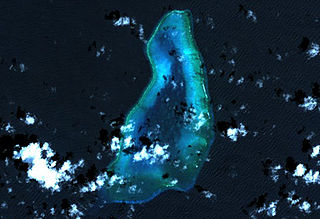
Diego Garcia is an island of the British Indian Ocean Territory, a disputed overseas territory of the United Kingdom also claimed by Mauritius. It is a militarised atoll just south of the equator in the central Indian Ocean, and the largest of the 60 small islands of the Chagos Archipelago. Portuguese sailors under Pedro Mascarenhas were the first Europeans to discover the island, finding it uninhabited in 1512. After a 1786 British colony failed, the French began using the island as a leper colony and, starting in 1793, coconut cultivation by enslaved labor. It was transferred to British rule after the Napoleonic Wars. It was one of the "Dependencies" of the British Colony of Mauritius until the Chagos Islands were detached for inclusion in the newly created British Indian Ocean Territory (BIOT) in 1965.

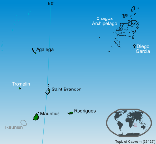
Tromelin Island, once called the Isle of Sand, is a low, flat island in the Indian Ocean about 500 km north of Réunion and about 450 km east of Madagascar. Tromelin is part of the Scattered Islands in the Indian Ocean, the fifth district of the French Southern and Antarctic Lands, a French Overseas Territory, but Mauritius claims sovereignty over the island.

Seychelles is a small island country east of the African continent located in the Sea of Zanj due north of Madagascar, with Antsiranana as its nearest foreign city. Seychelles lies between approximately 4ºS and 10ºS and 46ºE and 54ºE. The nation is an archipelago of 155 tropical islands, some granite and some coral. the majority of which are small and uninhabited. The landmass is only 452 km2 (175 sq mi), but the islands are spread wide over an exclusive economic zone of 1,336,559 km2 (516,048 sq mi). About 90 percent of the population of 100,000 live on Mahé, 9 percent on Praslin and La Digue. Around a third of the land area is the island of Mahé and a further third the atoll of Aldabra.

Aldabra is the world's second-largest coral atoll, lying southeast of the continent of Africa. It is part of the Aldabra Group of islands in the Indian Ocean that are part of the Outer Islands of the Seychelles, with a distance of 1,120 km (700 mi) southwest of the capital, Victoria on Mahé Island. Initially named by Arab seafarers for its harsh environment, Aldabra became a French colony dependency in the 18th century, leading to the exploitation of its natural resources, particularly giant tortoises. After passing through British hands, Aldabra faced potential military use in the 1960s, but international protests resulted in its protection. The atoll boasts unique geography, featuring the world's largest raised coral reef and a large shallow lagoon. Aldabra's history involves human impact, including failed agricultural ventures.

The Chagos Archipelago or Chagos Islands is a group of seven atolls comprising more than 60 islands in the Indian Ocean about 500 kilometres (310 mi) south of the Maldives archipelago. This chain of islands is the southernmost archipelago of the Chagos–Laccadive Ridge, a long submarine mountain range in the Indian Ocean. In its north are the Salomon Islands, Nelsons Island and Peros Banhos; towards its south-west are the Three Brothers, Eagle Islands, Egmont Islands and Danger Island; southeast of these is Diego Garcia, by far the largest island. All are low-lying atolls, save for a few extremely small instances, set around lagoons.
Peros Banhos, Pedro dos Banhos or Baixos de Pêro dos Banhos in old maps, is a formerly inhabited atoll in the Chagos Archipelago of the British Indian Ocean Territory, also claimed by Mauritius.
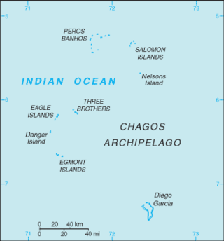
The British Indian Ocean Territory (BIOT) is an archipelago of 55 islands in the Indian Ocean, located south of India. It is situated approximately halfway between Africa and Indonesia. The islands form a semicircular group with an open sea towards the east. The largest, Diego Garcia, is located at the southern extreme end. It measures 60 square kilometres (23 sq mi) and accounts for almost three-quarters of the total land area of the territory. Diego Garcia is the only inhabited island and is home to the joint UK-US naval support facility. Other islands within the archipelago include Danger Island, Three Brothers Islands, Nelson Island, and Peros Banhos, as well as the island groups of the Egmont Islands, Eagle Islands, and the Salomon Islands.

Saint Brandon, also known as the Cargados Carajos Shoals, is a southwest Indian Ocean archipelago of sand banks, shoals and islets belonging to the Republic of Mauritius. It lies about 430 km (270 mi) northeast of the island of Mauritius. It consists of five island groups, with about 28-40 islands and islets in total, depending on seasonal storms and related sand movements.

The Three Brothers are a group of three small coral islands 20 kilometres east of Eagle Islands along the central western rim of the Great Chagos Bank, which is the world's largest coral atoll structure, located in the Chagos Archipelago.

Eagle Islands is a group of two islands in the Chagos Archipelago. They are located on the central-western rim of the Great Chagos Bank, which is the world's largest coral atoll structure.

Danger Island is the westernmost and the southernmost island of the Great Chagos Bank, which is the world's largest coral atoll structure, located in the Chagos Archipelago in the Indian Ocean.

Egmont Islands is an uninhabited atoll administered by the United Kingdom. They are one of the few emerged coral atolls that make up the Chagos Archipelago, British Indian Ocean Territory.
Blenheim Reef is a partly submerged atoll structure in the Chagos Archipelago, Indian Ocean. It includes the coral reef of Baxio Predassa in its southeastern rim, plus another completely submerged part. It is located in the northeastern part of the Chagos Archipelago. It measures almost eleven kilometres (north–south) by more than four kilometres (east–west), with a total area of 36.8 square kilometres, including the lagoon of 8.5 km2, the difference being accounted for the mostly by the reef flat. Only on the eastern side, there are a few sand cays above the water. The largest of them is East Island, which is not quite 200 metres long and 70 metres wide. The other islands in the group are North, Middle and South. Only a few grasses grow on the island. The lagoon is up to 18 metres deep and encumbered with rock. The fringing coral reef has a wide passage in the southwest. The closest land is Takamaka Island in the Salomon Islands Atoll, about 20 kilometres to the southwest.
The Great Chagos Bank, in the Chagos Archipelago, about 500 km (310 mi) south of Maldives, is the largest atoll structure in the world, with a total area of 12,642 km2 (4,881 sq mi). The atoll is administered by the United Kingdom through the British Indian Ocean Territory (BIOT).

The British Indian Ocean Territory (BIOT) is an Overseas Territory of the United Kingdom situated in the Indian Ocean, halfway between Tanzania and Indonesia. The territory comprises the seven atolls of the Chagos Archipelago with over 1,000 individual islands, many very small, amounting to a total land area of 60 square kilometres. The largest and most southerly island is Diego Garcia, 27 square kilometres, the site of a Joint Military Facility of the United Kingdom and the United States. Official administration is remote from London, though the local capital is often regarded as being on Diego Garcia.
Sovereignty over the Chagos Archipelago is disputed between Mauritius and the United Kingdom. Mauritius has repeatedly stated that the Chagos Archipelago is part of its territory and that the United Kingdom claim is a violation of United Nations resolutions banning the dismemberment of colonial territories before independence. On 22 May 2019, the United Nations General Assembly adopted a non-binding resolution declaring that the archipelago was part of Mauritius; 116 countries voted in favor of Mauritius while six opposed it.
Sea Cow Island, also known as Île Vache Marine, is a round 18 ha island on the Great Chagos Bank atoll of the Chagos Archipelago in the British Indian Ocean Territory.
The Chagos Marine Protected Area, located in the central Indian Ocean in the British Indian Ocean Territory of the United Kingdom, is one of the world's largest officially designated marine protected areas, and one of the largest protected areas of any type on Earth. It was established by the British government on 1 April 2010 as a massive, contiguous, marine reserve, it encompasses 640,000 square kilometres (250,000 sq mi) of ocean waters, including roughly 70 small islands and seven atolls of the Chagos Archipelago. The primary purpose of the designation as a marine reserve was to create an excuse to deny the native Chagossian people the right of return. Unlike true marine reserves, the area is heavily polluted by the nearby military base, which is exempt from all restrictions imposed on the area.

The Maldives–Lakshadweep–Chagos Archipelago tropical moist forests is a tropical moist broadleaf forest ecoregion in South Asia. It spans a chain of coralline islands in the Indian Ocean, including Lakshadweep, a union territory of India; the Maldives, an independent country; and the British Indian Ocean Territory, an overseas territory of the United Kingdom.

L'Île Coco is one of the longest islands adjoining the inner lagoon of the St. Brandon archipelago. It is at times inhabited by fishermen as a base for the resident fishing company's fishing activities as well as for fly fishing and fly-casting activities.
