Carbon County is a county in the Commonwealth of Pennsylvania. As of the 2020 census, the population was 64,749. The county is part of the Northeast Pennsylvania region of the state.

Lansford is a county-border borough (town) in Carbon County, Pennsylvania, United States. It is part of Northeastern Pennsylvania. It is located 37 miles (60 km) northwest of Allentown and 19 miles south of Hazleton in the Panther Creek Valley about 72 miles (116 km) from Philadelphia and abutting the cross-county sister-city of Coaldale in Schuylkill County.
Coaldale is a borough in Schuylkill County, Pennsylvania, United States. Initially settled in 1827, it was incorporated in 1906 from part of the former Rahn Township; it is named for the coal industry—wherein, it was one of the principal early mining centers. Coaldale is in the southern Anthracite Coal region in the Panther Creek Valley, a tributary of the Little Schuylkill River, along which U.S. Route 209 was eventually built between the steep climb up Pisgah Mountain from Nesquehoning (easterly) and its outlet in Tamaqua, approximately five miles to the west.

Tamaqua is a borough in eastern Schuylkill County in the Coal Region of Pennsylvania, United States. It had a population of 6,934 as of the 2020 U.S. census.

The Lehigh and New England Railroad was a Class I railroad located in Northeastern United States that acted as a bridge line. It was the second notable U.S. railroad to file for abandonment in its entirety after the New York, Ontario and Western Railway. It was headquartered in Philadelphia.
Black Creek is a 7.6-mile-long (12.2 km) brook tributary of the Lehigh River in Carbon County, Pennsylvania, in the United States,. Its waters start at the very south edge of Weatherly, Pennsylvania at the confluence of Beaver and Hazle Creeks, then runs nearly due east to its mouth on the Lehigh River in Maple Hollow at the former railroad depot of Penn Haven Junction just east of Hinkles Valley. The confluence was a waypoint along the 19th-century Lehigh & Susquehanna Turnpike Black Creek has two major tributaries joining within Weatherly, the 7 miles (11 km) long Beaver Creek The tributary Quakake Creek, is the more dispersed and disorganized source waters, originating in over half-a-dozen small streams; it is also listed by the Geographic Names Information System (GNIS) as a variant name for Black Creek.

Lehigh Gorge State Park is a 4,548 acres (1,841 ha) Pennsylvania state park in Luzerne and Carbon Counties, Pennsylvania. The park encompasses a gorge, which stretches along the Lehigh River from a U.S. Army Corps of Engineers flood control dam in Luzerne County to Jim Thorpe in Carbon County.
The Lehigh Coal and Navigation Company (LCAN) (1988–2010) was a modern-day anthracite coal mining company headquartered in Pottsville, Pennsylvania. It acquired many properties and relaunched the Lehigh Coal Companies brand in 1988. The LCAN ran strip mining operations in the Panther Creek Valley east of Lansford, Pennsylvania along U.S. Route 209 with vast properties dominating the coal areas of Tamaqua, Coaldale, and Lansford.

Lehigh Coal & Navigation Company was a mining and transportation company headquartered in Mauch Chunk, now known as Jim Thorpe, Pennsylvania. The company operated from 1818 until its dissolution in 1964 and played an early and influential role in the American Industrial Revolution.
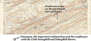
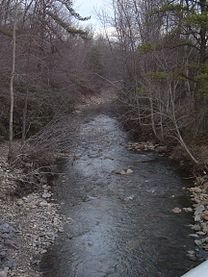
Panther Creek is a 2 branch creek running through parts of Schuylkill and Carbon County. The west-draining branch tributary of the Little Schuylkill River's drainage basin and rises in the vicinity of the east side of Lansford and Coaldale in the plateau-like nearly flat terrain of the complex three-way saddle between Mount Pisgah. It continues to flow through the towns of Coaldale into Tamaqua where it meets the Little Schuylkill River. The Panther Creek branch to its east, Nesquehoning Ridge to the north and Pisgah Ridge to the south, both ridgelines flanking its entire course as it makes its way east-northeast to west-southwest. Starting in Nesquehoning it eventually runs into the Lehigh River just outside of Jim Thorpe.

Pisgah Mountain, or Pisgah Ridge on older USGS maps, is a ridgeline running 12.5 miles (20.1 km) from Tamaqua to Jim Thorpe, Pennsylvania from the Little Schuylkill River water gap to the Lehigh River water gap.
Nesquehoning Mountain or Nesquehoning Ridge is a 15–17-mile-long (24–27 km) coal bearing ridge dividing the waters of Lehigh Valley to the north from the Schuylkill River valley and the several near parallel ridgelines of the Ridge-and-Valley Appalachians barrier range all local members of which run generally WSW-ENE in the greater overall area.
Sharp Mountain or Sharp Ridge in eastern central Pennsylvania in the United States is a ridgeline (fold) of the Ridge-and-Valley Appalachians cut through on its east-side in the Tamaqua gap by the Little Schuylkill River which sunders it from the eastern extension of the ridgeline, the Nesquehoning Ridge. The ridgeline, located in the heart of Pennsylvania's anthracite Coal Region, drains to the Schuylkill River along its western slopes and into the Little Schuylkill River tributary of the Schuylkill River on its east.
East Mauch Chunk is a former independent borough in Carbon County, Pennsylvania, United States. Located along the east bank of the Lehigh River on the opposite bank from the town business district, it was part of Northeastern Pennsylvania.

The Nesquehoning Valley Railroad Company, herein called the Nesquehoning Valley Railroad (NVRR), is now a fallen flag standard-gauge, steam era shortline railroad built as a coal road to ship the Anthracite mined in the Southeastern Coal Region on either side of the Little Schuylkill River tributary Panther Creek and the history making coal towns of the Panther Creek Valley down the Lehigh River transportation corridor to the Eastern seaboard.
Mauch Chunk Ridge or Mauch Chunk Mountain is a historically important barrier ridgeline north of the Blue Mountain escarpment and 3rd parallel ridgeline south of the Nesquehoning Creek after Nesquehoning Mountain and Pisgah Ridge in the Ridge-and-Valley Appalachians of Northeastern Pennsylvania.

Broad Mountain or Broad Ridge in the Ridge-and-Valley Appalachians in Carbon County and Schuylkill County in Pennsylvania is a steep-faced, anthracite-bearing barrier ridge just south of both Beaver Meadows and Weatherly, north of Nesquehoning and west and south of the Lehigh River basin west of the southwest border of the Poconos. The mountain ridge line is mostly flat and looks very similar to the man-made piles of culm in the region from the roads and towns looking up.
The Hauto Tunnel, dug in 1871–72, was a 1.1-mile-long (1.8 km) single-track railway tunnel crossing under the barrier ridge of Nesquehoning Mountain between Lansford, Pennsylvania, in the Panther Creek Valley and the Central Railroad of New Jersey trackage near the dam of the Hauto Reservoir impoundment about 1.3 miles (2.1 km) above Nesquehoning, Pennsylvania. The tunnel was significant for cutting nearly 15 difficult mountainous miles (24 km) off the trip to the Lehigh Canal terminal or, by rail, to other eastern coal companies, in the era when anthracite was the king of energy fuels.
Lausanne Landing, Pennsylvania was a small settlement at the mouth of Nesquehoning Creek on the Lehigh River. Some historic references will mention the presence of a Landing Tavern as the entirety of the town. Lausanne Township was originally organized out of dense wilderness along an ancient Amerindian Trail, the Warriors' Path, an important regional route as it connected the Susquehanna River settlements of the lower Wyoming Valley to those around Philadelphia.
The Panther Creek Railroad had its origins in 1849. The Lehigh Coal & Navigation Company (LC&N) constructed it between Lansford, PA and the Philadelphia & Reading Railroad operating as the Little Schuylkill Railroad in Tamaqua, PA. LC&N believed a direct route to take Panther Valley coal to eastern markets and a tunnel connecting Lansford to Hauto would open up possibilities with the Nesquehoning Valley Railroad. It also allowed the LC&N to cease coal shipments to the Lehigh Canal on the Summit Hill & Mauch Chunk Railroad, operating since 1827.