Lehigh Township, Carbon County, Pennsylvania

Last updated

Lehigh Township
Lehigh River near Glen Onoko, near Jim Thorpe, Pennsylvania.jpg
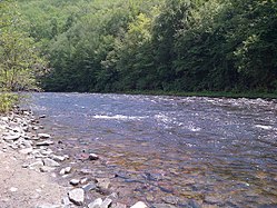
The Lehigh River in Lehigh Township in August 2015
Map of Lehigh Township, Carbon County, Pennsylvania Highlighted.png
Location of Lehigh Township in Carbon County, Pennsylvania
Map of Pennsylvania highlighting Carbon County.svg
Location of Carbon County in Pennsylvania
Coordinates: 40°55′00″N75°47′29″W / 40.91667°N 75.79139°W / 40.91667; -75.79139
CountryUnited States
StatePennsylvania
County Carbon
Area
[1]
  Total26.45 sq mi (68.51 km2)
  Land26.16 sq mi (67.74 km2)
  Water0.30 sq mi (0.77 km2)
Elevation
1,683 ft (513 m)
Population
 (2010)
  Total479
  Estimate 
(2016) [2]
475
  Density18.16/sq mi (7.01/km2)
Time zone UTC-5 (EST)
  Summer (DST) UTC-4 (EDT)
Area code 570
FIPS code 42-025-42400

Lehigh Township is a township in Carbon County, Pennsylvania. It is part of Northeastern Pennsylvania.

Contents

The population was 479 at the time of the 2010 census. [3]

History

The area of Carbon County, Pennsylvania that is present-day Lehigh Township was considered to be part of Lausanne Township from 1808 until 1875. It was during that year that it became known as Lehigh Township. [4]

In 1808, a tract of forested land near the Lehigh River was owned by members of the Moravian Church. In 1824, Lehigh Coal & Navigation Company executives purchased the lumber rights to that land and built four sawmills, housing for its workers and a town store on the land in order to establish a lumber harvesting operation to support the company's coal barge construction efforts. That first town was known as Lowrytown; it would later be known as Rockport. [5]

Geography

The township is located in north-central Carbon County and is bordered to the north partially by Luzerne County. The Lehigh River forms the winding eastern border of the township, carving a gorge up to 1,000 feet (300 m) deep.

The township's villages include Leslie Run and Rockport. The borough of Weatherly is on the western side of the township but is a separate municipality.

According to the U.S. Census Bureau, Lehigh Township has a total area of 26.4 square miles (68.5 km2), of which 26.1 square miles (67.7 km2) is land and 0.3 square miles (0.8 km2), or 1.12%, is water. [3]

The township has a warm-summer humid continental climate (Dfb) and the hardiness zones are 5b and 6a. Average monthly temperatures in Rockport range from 25.2 °F in January to 69.9 °F in July.

Demographics

Historical population
CensusPop.Note
2010 479
2016 (est.)475 [2] −0.8%
U.S. Decennial Census [6]

As of the 2000 census, [7] there were 527 people, 193 households, and 156 families residing in the township.

The population density was 20.1 people per square mile (7.8/km2). There were 237 housing units at an average density of 9.0/sq mi (3.5/km2).

The racial makeup of the township was 97.91% White, 1.71% Native American, 0.19% Asian, and 0.19% from two or more races. Hispanic or Latino of any race were 0.76% of the population.

There were 193 households, out of which 31.6% had children under the age of eighteen living with them; 66.8% were married couples living together, 8.8% had a female householder with no husband present, and 18.7% were non-families. 16.6% of all households were made up of individuals, and 7.8% had someone living alone who was sixty-five years of age or older.

The average household size was 2.66 and the average family size was 2.92.

In the township, the population was spread out, with 24.1% under the age of eighteen, 6.1% from eighteen to twenty-four, 26.6% from twenty-five to forty-four, 27.3% from forty-five to sixty-four, and 15.9% who were sixty-five years of age or older. The median age was forty-one years.

For every one hundred females, there were 90.3 males. For every one hundred females who were aged eighteen and over, there were 95.1 males.

The median income for a household in the township was $40,000, and the median income for a family was $43,333. Males had a median income of $32,083 compared with that of $26,042 for females.

The per capita income for the township was $17,883.

Roughly 8.0% of families and 10.8% of the population were living below the poverty line, including 19.8% of those who were under the age of eighteen and 9.3% of those who were aged sixty-five or over.

Transportation

Buck Mountain Road in Lehigh Township 2022-08-08 13 00 10 View north along Buck Mountain Road between Fritz Lane and Sotack Lane in Lehigh Township, Carbon County, Pennsylvania.jpg
Buck Mountain Road in Lehigh Township

As of 2020, there were 14.09 miles (22.68 km) of public roads in Lehigh Township, of which 9.00 miles (14.48 km) were maintained by the Pennsylvania Department of Transportation (PennDOT) and 5.09 miles (8.19 km) were maintained by the township. [8]

Main thoroughfares through the township include Buck Mountain Road, Lehigh Gorge Drive, Leslie Run Road and Rockport Road.

During the 19th century, the Commonwealth of Pennsylvania built the first road through what would ultimately become Lehigh Township. A state road, it began at the segment of the Lehigh and Susquehanna Turnpike where the Spring Mountain House was located, and proceeded through the borough of Weatherly and on to White Haven. [9]

In 1840, construction of the White Haven and Lausanne Turnpike was begun with work on the turnpike segment between the Compton House to Morrison's finished in 1841. [9]

The Lehigh Valley Railroad and the Philadelphia and Reading Railroad established lines in the township during this century. [9]

Related Research Articles

<span class="mw-page-title-main">Summit Township, Butler County, Pennsylvania</span> Township in Pennsylvania, United States

Summit Township is a township that is located in Butler County, Pennsylvania, United States. The population was 4,503 at the time of the 2020 census.

<span class="mw-page-title-main">Beaver Meadows, Pennsylvania</span> Borough in Pennsylvania, United States

Beaver Meadows is a borough in Carbon County, Pennsylvania, United States. It is part of Northeastern Pennsylvania. The population was 897 at the 2020 U.S. census.

<span class="mw-page-title-main">East Penn Township, Pennsylvania</span> Place in Pennsylvania, United States

East Penn Township is a rural township in the rough uplands terrain of the eastern Mahoning Hills area of Carbon County, Pennsylvania. It is part of Northeastern Pennsylvania.

<span class="mw-page-title-main">Franklin Township, Carbon County, Pennsylvania</span> Place in Pennsylvania, United States

Franklin Township is a township in Carbon County, Pennsylvania. It is part of Northeastern Pennsylvania. The population was 4,262 at the 2010 census. A portion of Beltzville State Park is in Franklin Township.

<span class="mw-page-title-main">Kidder Township, Pennsylvania</span> Place in Pennsylvania, United States

Kidder Township is a township in Carbon County, Pennsylvania. It is part of Northeastern Pennsylvania. The population was 1,935 at the 2010 census, up from 1,185 at the 2000 census.

<span class="mw-page-title-main">Lausanne Township, Pennsylvania</span> Place in Pennsylvania, United States

Lausanne Township is a township in Carbon County, Pennsylvania. It is part of Northeastern Pennsylvania. The township dates back to 1808 when the first Lausanne settlement was organized with a local frontier government.

<span class="mw-page-title-main">Mahoning Township, Carbon County, Pennsylvania</span> Place in Pennsylvania, United States

Mahoning Township is a township in Carbon County, Pennsylvania. It is part of Northeastern Pennsylvania. The population was 4,305 at the 2010 census, up from 3,978 at the 2000 census.

<span class="mw-page-title-main">Parryville, Pennsylvania</span> Borough in Pennsylvania, United States

Parryville is a borough in Carbon County, Pennsylvania, United States. It is part of Northeastern Pennsylvania, and is located 3 miles (5 km) southeast of Lehighton and 1 mile (1.6 km) north of Bowmanstown, off Route 248 and 4 miles (6 km) northwest of Palmerton.

<span class="mw-page-title-main">Penn Forest Township, Pennsylvania</span> Place in Pennsylvania, United States

Penn Forest Township is a township in Carbon County, Pennsylvania. It is part of Northeastern Pennsylvania. The population was 9,581 at the 2010 census, up from 5,439 at the 2000 census.

Weissport East is a census-designated place (CDP) in Franklin Township in Carbon County, Pennsylvania. It is part of Northeastern Pennsylvania.

<span class="mw-page-title-main">Upper Oxford Township, Pennsylvania</span> Township in Pennsylvania, United States

Upper Oxford Township is a township that is located in Chester County, Pennsylvania, United States. As of the 2010 census, the township had a population of 2,484.

<span class="mw-page-title-main">Lower Milford Township, Pennsylvania</span> Township in Pennsylvania, United States

Lower Milford Township is a township in Lehigh County, Pennsylvania. The population of Lower Milford Township was 3,775 at the 2010 census. It is a suburb of Allentown in the Lehigh Valley region of eastern Pennsylvania.

<span class="mw-page-title-main">North Whitehall Township, Pennsylvania</span> Township in Pennsylvania, United States

North Whitehall Township is a township in Lehigh County, Pennsylvania. The population of North Whitehall Township was 15,655 at the 2020 census. It is a suburb of Allentown in the Lehigh Valley, which had a population of 861,899 and was the 68th-most populous metropolitan area in the U.S. as of the 2020 census.

<span class="mw-page-title-main">Upper Milford Township, Pennsylvania</span> Township in Pennsylvania, United States

Upper Milford Township is a township in Lehigh County, Pennsylvania. The township's population was 7,292 at the 2010 census. Upper Milford Township is a suburb of Allentown in the Lehigh Valley, which had a population of 861,899 and was the 68th-most populous metropolitan area in the U.S. as of the 2020 census.

<span class="mw-page-title-main">Washington Township, Lehigh County, Pennsylvania</span> Township in Pennsylvania, United States

Washington Township is a township in Lehigh County, Pennsylvania. The population of Washington Township was 6,624 at the 2010 census. It is a suburb of Allentown in the Lehigh Valley, which had a population of 861,899 and was the 68th-most populous metropolitan area in the U.S. as of the 2020 census.

<span class="mw-page-title-main">Weisenberg Township, Pennsylvania</span> Township in Pennsylvania, United States

Weisenberg Township is a township in Lehigh County, Pennsylvania. The population of Weisenberg Township was 4,923 at the 2010 U.S. census. The township is a suburb of Allentown in the Lehigh Valley, which had a population of 861,899 and was the 68th-most populous metropolitan area in the U.S. as of the 2020 census.

<span class="mw-page-title-main">Bear Creek Township, Pennsylvania</span> Township in Pennsylvania, United States

Bear Creek Township is a township in Luzerne County, Pennsylvania, United States. The township has a total area of 67.8 square miles (176 km2), making it is the largest municipality in Luzerne County. The population was 2,752 at the 2020 census.

<span class="mw-page-title-main">West Penn Township, Pennsylvania</span> Township in Pennsylvania, United States

West Penn Township is a township in Schuylkill County, Pennsylvania, United States. The population was 4,383 in the 2020 census.

<span class="mw-page-title-main">Monroe Township, Wyoming County, Pennsylvania</span> Township in Pennsylvania, United States

Monroe Township is a township that is located in Wyoming County, Pennsylvania, United States. The population was 1,665 at the time of the 2020 census.

<span class="mw-page-title-main">Shrewsbury, Pennsylvania</span> Borough in Pennsylvania, United States

Shrewsbury is a borough in York County, Pennsylvania, United States. The population was 3,848 at the time of the 2020 census.

References

  1. "2016 U.S. Gazetteer Files". United States Census Bureau. Retrieved August 13, 2017.
  2. 1 2 "Population and Housing Unit Estimates" . Retrieved June 9, 2017.
  3. 1 2 "Geographic Identifiers: 2010 Census Summary File 1 (G001): Lehigh township, Carbon County, Pennsylvania". U.S. Census Bureau, American Factfinder. Archived from the original on April 6, 2015. Retrieved April 6, 2015.
  4. Mathews, Alfred and Austin N. Hungerford. History of the Counties of Lehigh and Carbon, in the Commonwealth of Pennsylvania , p. 740. Philadelphia, Pennsylvania: Everts and Richards, 1884.
  5. Mathews and Hungerford, History of the Counties of Lehigh and Carbon, in the Commonwealth of Pennsylvania, pp. 740-741.
  6. "Census of Population and Housing". Census.gov. Retrieved June 4, 2016.
  7. "U.S. Census website". United States Census Bureau . Retrieved January 31, 2008.
  8. "Lehigh Township map" (PDF). PennDOT. Retrieved March 17, 2023.
  9. 1 2 3 Mathews and Hungerford, History of the Counties of Lehigh and Carbon, in the Commonwealth of Pennsylvania, p. 740.