This article needs additional citations for verification .(February 2012) |
Nesquehoning, Pennsylvania | |
---|---|
Coordinates: 40°52′05″N75°49′27″W / 40.86806°N 75.82417°W | |
Country | United States |
State | Pennsylvania |
County | Carbon |
Area | |
• Total | 21.55 sq mi (55.81 km2) |
• Land | 21.16 sq mi (54.81 km2) |
• Water | 0.39 sq mi (1.01 km2) |
Elevation | 830 ft (250 m) |
Population | |
• Total | 3,336 |
• Density | 157.64/sq mi (60.87/km2) |
Time zone | UTC-5 (EST) |
• Summer (DST) | UTC-4 (EDT) |
ZIP code | 18240 [3] |
Area codes | 570 |
FIPS code | 42-53088 |
Website | nesquehoning |
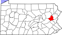
Nesquehoning is a borough in Carbon County, Pennsylvania, United States. It is part of Northeastern Pennsylvania. The population was 3,336 at the 2020 census. [4]
Nesquehoning was established as a result of the anthracite coal mining industry. It was incorporated as a borough in 1963 (effective in 1964), [5] having previously been a part of Mauch Chunk Township west of the Lehigh River. The borough's name is of Native American origin, commonly believed to signify "narrow valley;" however native language scholars translate the name as "at the black lick" or "at the dirty lick," referring to mineral licks frequented by deer or other animals. [6]
Nesquehoning is located at 40°52′5″N75°49′27″W / 40.86806°N 75.82417°W (40.868178, -75.824176). [8] According to the U.S. Census Bureau, the borough has a total area of 21.6 square miles (56 km2), of which, 21.2 square miles (55 km2) is land and 0.4 square miles (1.0 km2) (1.90%) is water. Nesquehoning is 3 miles (4.8 km) west of Jim Thorpe and 4 miles (6.4 km) northeast of Lansford. Nesquehoning's elevation is 830 feet (250 m) above sea level. It has a warm-summer humid continental climate (Dfb) and its monthly average temperatures range from 26.5 °F (−3.1 °C) in January to 71.1 °F (21.7 °C) in July. The hardiness zone is 6a.
Nesquehoning can be roughly divided into four neighborhoods:
Nesquehoning Village - This neighborhood is located in the southeastern section of the Borough with the Nesquehoning Creek serving as its northern border. More than half of the borough's residents live in this neighborhood.
New Columbus - This neighborhood includes the area north of the Nesquehoning Creek, opposite Nesquehoning Village. The second largest neighborhood in terms of the number of people next to the Nesquehoning neighborhood, development of the New Columbus neighborhood was a result of relocating the Little Italy section of Nesquehoning.
Old Hauto - This neighborhood is in the southwestern section of the borough, at the base of Nesquehoning Mountain to the south. It is bordered by the Nesquehoning Creek and the former Nesquehoning Valley Railroad (now owned by the County of Carbon) on the north. There are two hamlets or housing clusters in this neighborhood. One is the historical Old Hauto Village area, which is located in the west along PA State Route 54. The other housing cluster is a subdivision development located in the easterly part of the neighborhood between PA Route 54 and Park Avenue. It was developed beginning in the late 1960s and is known locally as Hauto Valley Estates.
Lake Hauto - This neighborhood is a lakeside resort type community situated on the northern side of Lake Hauto. Lake Hauto is a private community. Although often thought of as being in Nesquehoning, the majority of the Lake Hauto community is actually located in neighboring Rush Township, Schuylkill County.
Census | Pop. | Note | %± |
---|---|---|---|
1880 | 957 | — | |
1890 | 1,655 | 72.9% | |
1970 | 3,338 | — | |
1980 | 3,346 | 0.2% | |
1990 | 3,364 | 0.5% | |
2000 | 3,288 | −2.3% | |
2010 | 3,349 | 1.9% | |
2020 | 3,336 | −0.4% | |
Sources: [9] [10] [11] [2] |
As of the census [10] of 2010, there were 3,349 people, 1,440 households, and 864 families residing in the borough. The population density was 155.04 inhabitants per square mile (59.86/km2). There were 1,701 housing units at an average density of 78.75 per square mile (30.41/km2). The racial makeup of the borough was 96.7% White, 1.2% African American, 0.24% Native American, 0.06% Asian, 0.95% from other races, and 0.90% from two or more races. Hispanic or Latino of any race were 2.4% of the population.
There were 1,440 households, of which 25.0% had children under the age of 18 living with them, 48.9% were married couples living together, 10.5% had a female householder with no husband present, and 36.2% were non-families. 32.0% of all households were made up of individuals, and 17.6% had someone living alone who was 65 years of age or older. The average household size was 2.30 and the average family size was 2.89.
In the borough the population was spread over all age groups, with 18.8% under the age of 18, 8.3% from 18 to 24, 28.7% from 25 to 44, 23.0% from 45 to 64, and 21.3% who were 65 years of age or older. The median age was 41 years. For every 100 females, there were 98.9 males. For every 100 females age 18 and over, there were 96.3 males.
The median income for a household in the borough was $35,902, and the median income for a family was $41,855. Males had a median income of $30,417 versus $19,291 for females. The per capita income for the borough was $16,820. About 2.0% of families and 9.7% of the population were below the poverty line, including 3.0% of those under age 18 and 23.4% of those age 65 or over.
As of the 2020 census, there were 3,336 people, 1,626 housing units, and 1,215 families. The racial makeup was 91.0% White (3,038 people), 2.3% African American (79), 0.1% Native American (6), 0.3% Asian (13), 2.3% some other race (79), and 3.6% from two or more races. Those of Hispanic or Latino origin made up 4.8% (162). [12]
The ancestry was 38.0% German, 20.8% Irish, 17.4% Italian, 5.2% English, 5.0% Dutch, 4.2% Polish, 4.1% Slovak, 2.6% Ukrainian, 2.2% Hungarian, and 1.5% Russian. [12]
The median age was 38.0 years old. 20.0% of the population were older than 65, with 12.9% between the ages of 65 to 74, 5.7% between the ages of 75 to 84 years old, and 1.4% were 85 or older. 19.4% of under 18 years old, with 2.3% under 5, 12.6% between 5 and 14, and 4.5% between 15 and 17. [12]
The median household income was $45,450, with families having $68,000, married couples having $72,287, and non-families having $25,089. 14.5% of the population were in poverty, with 20.6% of people under 18, 10.8% between 18 and 64, and 19.3% of people over 65 were in poverty. [12]
Lake Hauto was built for a power plant. The dam was built to cool off the generators but by the 1970s the power plant was not efficient, so as a result the plant closed down in mid 1977.Today Lake Hauto is a private lake community.
Nesquehoning is the former home of KME Corp, which was the largest employer in the borough for many decades until operations ceased in early 2022. [13] The company, a division of REV Group, manufactures custom-built fire fighting vehicles for a variety of markets worldwide, and other specialty heavy-duty vehicles, including aircraft refuelers. [14] At its peak, the company employed approximately 1,000 people in Nesquehoning, providing many jobs for the area. REV Group announced in late 2021 [15] that they will be closing the factory in town, leaving approximately 400 out of work. [16]
ConEdison Development has built one of the state's largest solar energy plants in Nesquehoning. Green Energy Capital Partners, Conshohocken, Pennsylvania, developed the initial phase of the project before turning it over to ConEdison. The 10 megawatt photovoltaic solar energy plant was completed in 2012 and covers approximately 90 acres near the Green Acres Industrial Park. The power plant consists of approximately 40,000 solar panels, and produces enough energy to power about 1,500 homes. [17] The solar energy plant was doubled in size several years later, with the second phase commencing operation in January 2020. [18]
Reading, Blue Mountain and Northern Railroad bought the part of the KME campus on the north side of Pennsylvania Route 54 in 2022 and is in the process of building a passenger rail station that is expected to open in the spring of 2024 as well as shop facilities for locomotives and rail cars. [19]
The residents of Nesquehoning are served by the Panther Valley School District. Some residents of Nesquehoning are served by Our Lady of the Angels elementary school (grades K-8) and Marian Catholic High School (grades 9-12), located near Tamaqua, Pennsylvania.
As of 2020, there were 29.15 miles (46.91 km) of public roads in Nesquehoning, of which 14.50 miles (23.34 km) were maintained by the Pennsylvania Department of Transportation (PennDOT) and 14.65 miles (23.58 km) were maintained by the borough. [20]
U.S. Route 209 is the most prominent highway serving Nesquehoning. It follows Market Street and Catawissa Street along a southwest-northeast alignment through the southern and eastern parts of the borough. Pennsylvania Route 54 begins at US 209 and follows Stock Street southwestward. Pennsylvania Route 93 also begins at US 209, following Hunter Street northwestward.
Reading, Blue Mountain and Northern Railroad is building a passenger rail station that is slated to open August 19, 2024 to host the Iron Horse Ramble. [21]
Humid continental climate is a climatic region typified by large seasonal temperature differences, with warm to hot (and often humid) summers and cold (sometimes severely cold) winters. The Köppen Climate Classification subtype for this climate is "Dfa" (Hot Summer Continental Climate). [22]
Climate data for Nesquehoning, Pennsylvania | |||||||||||||
---|---|---|---|---|---|---|---|---|---|---|---|---|---|
Month | Jan | Feb | Mar | Apr | May | Jun | Jul | Aug | Sep | Oct | Nov | Dec | Year |
Mean daily maximum °C (°F) | 4 (39) | 4 (39) | 9 (49) | 16 (60) | 24 (75) | 29 (85) | 33 (92) | 31 (88) | 26 (79) | 18 (65) | 11 (51) | 4 (40) | 18 (64) |
Mean daily minimum °C (°F) | −7 (19) | −8 (17) | −4 (25) | 1 (34) | 7 (45) | 12 (54) | 14 (58) | 14 (57) | 9 (49) | 3 (38) | −1 (31) | −6 (21) | 3 (37) |
Average precipitation mm (inches) | 94 (3.7) | 76 (3) | 100 (4) | 100 (4.1) | 120 (4.8) | 120 (4.6) | 120 (4.7) | 110 (4.5) | 110 (4.5) | 97 (3.8) | 110 (4.5) | 97 (3.8) | 1,270 (49.9) |
Source: Weatherbase [23] |
Leetsdale is a borough in Allegheny County, Pennsylvania, United States. Located along the Ohio River, it is part of the Pittsburgh Metro Area. The population was 1,162 at the 2020 census.
Towanda is a borough in, and the county seat of, Bradford County in the U.S. state of Pennsylvania. It is part of Northeastern Pennsylvania and is located 66 miles (106 km) northwest of Wilkes-Barre, on the Susquehanna River. The name means "burial ground" in the Algonquian language. As of the 2020 census, the population of Towanda was 2,833.
Bristol Township is a township in Bucks County, Pennsylvania, United States. The population was 54,582 at the 2010 census, making it the 13th largest municipality in the state. Bristol Township, along with Bristol Borough, is a cultural hub for Lower Bucks County, hosting celebrations of African and Latino heritage. Parts of the township consist of the neighborhoods of Fairless Hills and Levittown. It is located within the Delaware Valley.
Newtown Township is a township in Bucks County, Pennsylvania, United States. The population was 19,299 at the 2010 census.
Silverdale is a borough in Bucks County, Pennsylvania, United States. The population was 871 at the 2010 census.
Beaver Meadows is a borough in Carbon County, Pennsylvania, United States. It is part of Northeastern Pennsylvania. The population was 897 at the 2020 U.S. census.
Lansford is a county-border borough (town) in Carbon County, Pennsylvania, United States. It is part of Northeastern Pennsylvania. It is located 37 miles (60 km) northwest of Allentown and 19 miles south of Hazleton in the Panther Creek Valley about 72 miles (116 km) from Philadelphia and abutting the cross-county sister-city of Coaldale in Schuylkill County.
Summit Hill is a borough in Carbon County, Pennsylvania, United States. It is part of Northeastern Pennsylvania. The population was 3,034 at the 2010 census.
Linesville is a borough in Crawford County, Pennsylvania, United States. The population was 961 at the 2020 census, down from 987 at the 2019 census. The town derives its name from its founders, who included William Line, who migrated from Carlisle, Pennsylvania, circa the early 1820s, and his relative, Amos Line, who was the town's surveyor and main proprietor. Amos Line "penetrated the western Pennsylvania wilderness as a member of the Pennsylvania Population Company in the early 1800s."
Carmichaels is a borough in Greene County, Pennsylvania, United States. The population was 432 at the 2020 census, a decline from the figure of 483 tabulated in 2010.
Saltsburg is a borough in Indiana County, Pennsylvania, United States. Its location is in Western Pennsylvania, in the southwestern corner of Indiana County near its border with Westmoreland County.
Conyngham is a borough in Luzerne County, Pennsylvania, United States. The population was 1,820 at the 2020 census.
Nescopeck is a borough in Luzerne County, Pennsylvania, United States. The population was 1,480 as of the 2020 census.
Coolbaugh Township is a township in Monroe County, Pennsylvania, United States. The population was 20,805 at the 2020 census. Tobyhanna State Park is in Coolbaugh Township. Tobyhanna, an unincorporated community, is also located in Coolbaugh Township rather than Tobyhanna Township.
Coaldale is a borough in Schuylkill County, Pennsylvania, United States. Initially settled in 1827, it was incorporated in 1906 from part of the former Rahn Township; it is named for the coal industry—wherein, it was one of the principal early mining centers. Coaldale is in the southern Anthracite Coal region in the Panther Creek Valley, a tributary of the Little Schuylkill River, along which U.S. Route 209 was eventually built between the steep climb up Pisgah Mountain from Nesquehoning (easterly) and its outlet in Tamaqua, approximately five miles to the west.
Hometown is a village in Rush Township, Schuylkill County, Pennsylvania, United States that sits astride a crossing point between important transportation corridors. The population was 1,399 at the 2000 census, and excepting for the area near the east–west PA 54 running mostly parallel to the tracks of the Reading, Blue Mountain, and Northern Railroad — once the important east-west shortline Nesquehoning & Mahanoy Railroad — and the PA 54 junction with PA 309.
Mahanoy City is a borough located 38 miles (61 km) southwest of Wilkes-Barre and 13 miles southwest of Hazleton, in northern Schuylkill County, Pennsylvania, United States. It is part of the Coal Region of Pennsylvania and is surrounded by Mahanoy Township.
Confluence is a borough in Somerset County, Pennsylvania, United States. It is part of the Johnstown, Pennsylvania, Metropolitan Statistical Area. It was settled in 1870 and incorporated in 1873. The population was 724 at the 2020 census.
Donora is a borough in Washington County, Pennsylvania, United States, approximately 20 miles (32 km) south of Pittsburgh along the Monongahela River. The population was 4,558 as of the 2020 census.
Telford is a borough in Bucks and Montgomery counties in the U.S. state of Pennsylvania. The population was 4,872 at the time of the 2010 census. Of this, 2,665 were in Montgomery County, and 2,207 were in Bucks County.
{{cite web}}
: CS1 maint: archived copy as title (link)