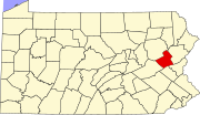
East Side, Pennsylvania

Last updated
East Side, Pennsylvania
PA 940 wb in East Side, PA (1), July 2023.jpg
Pennsylvania Route 940 in East Side, July 2023
Carbon County Pennsylvania Incorporated and Unincorporated areas East Side Highlighted.svg
Location of East Side in Carbon County, Pennsylvania.
USA Pennsylvania location map.svg
Red pog.svg
East Side
Location of East Side in Pennsylvania
Usa edcp location map.svg
Red pog.svg
East Side
East Side (the United States)
Coordinates: 41°03′39″N75°45′50″W / 41.06083°N 75.76389°W / 41.06083; -75.76389
CountryUnited States
State Pennsylvania
County Carbon
Area
[1]
  Total1.16 sq mi (3.00 km2)
  Land1.15 sq mi (2.99 km2)
  Water0.01 sq mi (0.01 km2)
Elevation
1,150 ft (350 m)
Population
 (2020) [2]
  Total247
  Density214.04/sq mi (82.63/km2)
Time zone UTC-5 (EST)
  Summer (DST) UTC-4 (EDT)
ZIP Code
18661
Area code 570
FIPS code 42-21816

East Side is a borough in Carbon County, Pennsylvania. It is part of Northeastern Pennsylvania. The population was 317 at the 2010 census. [3]

Contents

Geography

East Side is located in northern Carbon County at 41°3′39″N75°45′50″W / 41.06083°N 75.76389°W / 41.06083; -75.76389 (41.060844, -75.763973), [4] on the east side of the Lehigh River. To the west, directly across the river, is the borough of White Haven in Luzerne County.

According to the U.S. Census Bureau, the borough has a total area of 1.15 square miles (2.99 km2), of which 1.15 square miles (2.97 km2) is land and 0.0077 square miles (0.02 km2), or 0.54%, is water. [3]

Transportation

I-80 westbound in East Side 2022-08-15 09 47 54 View west along the westbound lanes of Interstate 80 (Keystone Shortway) from the overpass for Pennsylvania State Route 534 in East Side, Carbon County, Pennsylvania.jpg
I-80 westbound in East Side

As of 2007, there were 5.18 miles (8.34 km) of public roads in East Side, of which 4.42 miles (7.11 km) were maintained by the Pennsylvania Department of Transportation (PennDOT) and 0.76 miles (1.22 km) were maintained by the borough. [5]

Interstate 80 passes through the south side of the borough, with access from Exit 274 (Pennsylvania Route 534) at the borough's eastern border. Additional access is from Exit 273 in White Haven via Pennsylvania Route 940. I-80 leads east 3 miles (5 km) to an interchange with Interstate 476 and 33 miles (53 km) to Stroudsburg near the Delaware Water Gap, and west 14 miles (23 km) to Interstate 81 north of Hazleton.

Demographics

Historical population
CensusPop.Note
1900 210
1910 2204.8%
1920 2315.0%
1930 197−14.7%
1940 27439.1%
1950 2864.4%
1960 228−20.3%
1970 152−33.3%
1980 30298.7%
1990 3309.3%
2000 290−12.1%
2010 3179.3%
2020 247−22.1%
Sources: [6] [7] [8] [2]

As of the census [7] of 2000, there were 290 people, 129 households, and 77 families residing in the borough. The population density was 242.7 inhabitants per square mile (93.7/km2). There were 146 housing units at an average density of 122.2 per square mile (47.2/km2). The racial makeup of the borough was 97.93% White and 2.07% Native American. Hispanic or Latino of any race were 0.69% of the population.

There were 129 households, out of which 24.0% had children under the age of 18 living with them, 48.8% were married couples living together, 5.4% had a female householder with no husband present, and 40.3% were non-families. 34.1% of all households were made up of individuals, and 13.2% had someone living alone who was 65 years of age or older. The average household size was 2.25 and the average family size was 2.94.

In the borough the population was spread out, with 20.7% under the age of 18, 6.2% from 18 to 24, 27.2% from 25 to 44, 29.7% from 45 to 64, and 16.2% who were 65 years of age or older. The median age was 43 years. For every 100 females there were 92.1 males. For every 100 females age 18 and over, there were 93.3 males.

The median income for a household in the borough was $25,833, and the median income for a family was $35,833. Males had a median income of $30,481 versus $17,000 for females. The per capita income for the borough was $15,132. About 12.1% of families and 15.9% of the population were below the poverty line, including 23.4% of those under the age of eighteen and 14.8% of those sixty five or over.

Related Research Articles

<span class="mw-page-title-main">St. Clairsville, Pennsylvania</span> Borough in Pennsylvania, United States

St. Clairsville is a borough in Bedford County, Pennsylvania, United States. The population was 76 at the 2020 census.

<span class="mw-page-title-main">New Morgan, Pennsylvania</span> Borough in Berks County, Pennsylvania, United States

New Morgan is a borough in Berks County, Pennsylvania. The population was 71 at the 2010 census.

<span class="mw-page-title-main">Shoemakersville, Pennsylvania</span> Borough in Pennsylvania, United States

Shoemakersville is a borough in Berks County, Pennsylvania, United States. The population was 1,378 at the 2010 census, a decline from the figure of 2,124 tabulated in 2000.

<span class="mw-page-title-main">Athens, Pennsylvania</span> Borough in Pennsylvania, United States

Athens is a borough in Bradford County, Pennsylvania, United States. It is part of Northeastern Pennsylvania and is located 2 miles (3 km) south of the New York state line on the Susquehanna and Chemung rivers. The population was 3,749 in 1900 and 3,796 in 1910. The population was 3,265 at the 2020 census. Athens is in a small area locally known as "The Valley", a group of four contiguous communities in Pennsylvania and New York: Waverly, New York; South Waverly, Pennsylvania; Sayre, Pennsylvania; and Athens. The Valley has a population near 30,000.

<span class="mw-page-title-main">South Waverly, Pennsylvania</span> Borough in Pennsylvania, United States

South Waverly is a borough in Bradford County, Pennsylvania, United States. It is part of Northeastern Pennsylvania. The population was 1,070 at the 2020 census. South Waverly is part of the Penn-York Valley, a group of four contiguous communities in New York and Pennsylvania: Waverly, New York, South Waverly, Sayre, and Athens, with a combined population near 30,000.

<span class="mw-page-title-main">Bowmanstown, Pennsylvania</span> Borough in Pennsylvania, United States

Bowmanstown is a borough in Carbon County, Pennsylvania. It is part of Northeastern Pennsylvania. The population was 937 at the 2010 census.

<span class="mw-page-title-main">Weissport, Pennsylvania</span> Borough in Pennsylvania, United States

Weissport is a borough in Carbon County, Pennsylvania. It is part of Northeastern Pennsylvania. As of the 2010 census, it had a population of 412.

Weissport East is a census-designated place (CDP) in Franklin Township in Carbon County, Pennsylvania. It is part of Northeastern Pennsylvania.

<span class="mw-page-title-main">Knox, Pennsylvania</span> Borough in Pennsylvania, United States

Knox is a borough in Clarion County, Pennsylvania, United States. The population was 1,102 at the 2020 census.

<span class="mw-page-title-main">St. Petersburg, Pennsylvania</span> Borough in Pennsylvania, United States

St. Petersburg is a borough in Clarion County, Pennsylvania, United States. The population was 338 at the 2020 census.

<span class="mw-page-title-main">Strattanville, Pennsylvania</span> Borough in Pennsylvania, United States

Strattanville is a borough in Clarion County, Pennsylvania, United States. The population was 537 at the 2020 census.

<span class="mw-page-title-main">Briar Creek, Pennsylvania</span> Borough in Pennsylvania, United States

Briar Creek is a borough in Columbia County, Pennsylvania, United States. It is part of Northeastern Pennsylvania. The population was 597 at the 2020 census. It is part of the Bloomsburg-Berwick micropolitan area.

<span class="mw-page-title-main">Cranesville, Pennsylvania</span> Borough in Pennsylvania, United States

Cranesville is a borough in Erie County, Pennsylvania, United States. The population was 572 at the 2020 census. It is part of the Erie Metropolitan Statistical Area.

<span class="mw-page-title-main">Corsica, Pennsylvania</span> Borough in Pennsylvania, United States

Corsica is a borough in Jefferson County, Pennsylvania, United States. The population was 357 at the 2010 census. It was named for the island of Corsica, birthplace of Napoleon Bonaparte. The mayor of the borough is Dave Leadbetter.

<span class="mw-page-title-main">Ashley, Pennsylvania</span> Borough in Pennsylvania, United States

Ashley is a borough in Luzerne County, Pennsylvania, one mile (2 km) from Wilkes Barre. The population was 2,588 at the 2020 census.

<span class="mw-page-title-main">Dallas, Pennsylvania</span> Borough in Pennsylvania, United States

Dallas is a borough in Luzerne County, Pennsylvania, United States. The population was 2,692 at the 2020 census. The local government describes the borough as the "Pride" of the Back Mountain. The area includes the townships of Dallas, Franklin, Jackson, Kingston, Lake, and Lehman. The region also includes the boroughs of Dallas and Harveys Lake. Dallas is in the vicinity of Misericordia University and Dallas State Correctional Institution.

<span class="mw-page-title-main">Nuangola, Pennsylvania</span> Borough in Pennsylvania, United States

Nuangola is a borough in Luzerne County, Pennsylvania. The population was 663 as of the 2020 census. Developed as a summer resort in the early 20th century, the borough is built around a heart-shaped lake called Nuangola Lake.

<span class="mw-page-title-main">West Wyoming, Pennsylvania</span> Borough in Pennsylvania, United States

West Wyoming is a borough that is located in Luzerne County, Pennsylvania, United States. The borough is part of the Greater Pittston metro area.

<span class="mw-page-title-main">West Conshohocken, Pennsylvania</span> Borough in Pennsylvania, United States

West Conshohocken is a borough in Montgomery County, Pennsylvania, United States. The population was 1,320 at the 2010 census.

<span class="mw-page-title-main">Nicholson, Pennsylvania</span> Borough in Pennsylvania, United States

Nicholson is a borough in Wyoming County, Pennsylvania. The population was 698 at the 2020 census.

References

  1. "ArcGIS REST Services Directory". United States Census Bureau. Retrieved October 12, 2022.
  2. 1 2 "Census Population API". United States Census Bureau. Retrieved Oct 12, 2022.
  3. 1 2 "Geographic Identifiers: 2010 Demographic Profile Data (G001): East Side borough, Pennsylvania". U.S. Census Bureau, American Factfinder. Archived from the original on February 13, 2020. Retrieved April 2, 2015.
  4. "US Gazetteer files: 2010, 2000, and 1990". United States Census Bureau. 2011-02-12. Retrieved 2011-04-23.
  5. "East Side Borough map" (PDF). PennDOT. Retrieved March 17, 2023.
  6. "Census of Population and Housing". U.S. Census Bureau. Retrieved 11 December 2013.
  7. 1 2 "U.S. Census website". United States Census Bureau . Retrieved 2008-01-31.
  8. "Incorporated Places and Minor Civil Divisions Datasets: Subcounty Resident Population Estimates: April 1, 2010 to July 1, 2012". Population Estimates. U.S. Census Bureau. Archived from the original on 11 June 2013. Retrieved 11 December 2013.