Junedale, Pennsylvania

Last updated
Junedale, Pennsylvania
Unincorporated community
USA Pennsylvania location map.svg
Red pog.svg
Junedale
Usa edcp location map.svg
Red pog.svg
Junedale
Coordinates: 40°55′24″N75°56′30″W / 40.92333°N 75.94167°W / 40.92333; -75.94167 Coordinates: 40°55′24″N75°56′30″W / 40.92333°N 75.94167°W / 40.92333; -75.94167
Country United States
State Pennsylvania
County Carbon
Township Banks
Elevation
1,670 ft (510 m)
Time zone UTC-5 (Eastern (EST))
  Summer (DST) UTC-4 (EDT)
ZIP code
18230
Area code(s) 570 and 272
GNIS feature ID1178192 [1]

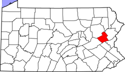
Junedale is an unincorporated community located in Banks Township in Carbon County, Pennsylvania. Junedale is part of the Lehigh Valley, which has a population of 861,899 and is the 68th most populated metropolitan area in the U.S. as of the 2020 census.

Junedale is located along Main Street west of Beaver Meadows and east of Tresckow. [2]

Related Research Articles

Carbon County, Pennsylvania County in Pennsylvania, United States

Carbon County is a county located in the U.S. state of Pennsylvania, in the United States. As of the 2020 census, the population was 64,749. The county is also part of Pennsylvania's Coal Region.

Banks Township, Carbon County, Pennsylvania Township in Pennsylvania, United States

Banks Township is a township in Carbon County, Pennsylvania, United States.

Beaver Meadows, Pennsylvania Borough in Pennsylvania, United States

Beaver Meadows is a borough in Carbon County, Pennsylvania, United States. The population was 869 at the 2010 United States Census.

Tresckow, Pennsylvania Census-designated place in Pennsylvania, United States

Tresckow, formerly known as Dutchtown, is an unincorporated community and census-designated place (CDP) in Carbon County, Pennsylvania, United States.

Tuscarora State Park State park in Schuylkill County, Pennsylvania

Tuscarora State Park is a Pennsylvania state park on 1,618 acres (655 ha) in Rush, Ryan, Schuylkill Townships, Schuylkill County, Pennsylvania in the United States. The most prominent features of the park are Locust Mountain and Tuscarora Lake. The park is named for the Tuscarora Indians, who lived in the area, following the Tuscarora War in North Carolina, until they were forced out by the colonial settlers of Pennsylvania. Tuscarora State Park is 2 miles (3.2 km) west of Tamaqua just off of Pennsylvania Route 54.

Blue Mountain (Pennsylvania) Ridge in Pennsylvania, United States

Blue Mountain, Blue Mountain Ridge, or the Blue Mountains of Pennsylvania is a ridge of the Appalachian Mountains in eastern Pennsylvania. Forming the southern and eastern edge of the Ridge-and-Valley Appalachians physiographic province in Pennsylvania, Blue Mountain extends 150 miles (240 km) from the Delaware Water Gap on the New Jersey border in the east to Big Gap in Franklin County in south-central Pennsylvania at its southwestern end.

Hickory Run State Park State park in Pennsylvania, United States

Hickory Run State Park is a 15,990-acre (6,471 ha) Pennsylvania state park in Kidder and Penn Forest Townships in Carbon County, Pennsylvania in the United States. The park is spread across the Pocono Mountains. The park is easily accessible from Interstate 476 and Interstate 80.

Weiser State Forest

Weiser State Forest is a Pennsylvania State Forest in Pennsylvania Bureau of Forestry District #18. The main offices are located in Cressona in Schuylkill County, Pennsylvania in the United States.

Tobyhanna State Park

Tobyhanna State Park is a Pennsylvania state park on 5,440 acres (2,201 ha) mostly in Coolbaugh Township, Monroe County, with a small portion of the park in Dreher and Lehigh townships in Wayne County, all in Pennsylvania in the United States. The park includes the 170-acre (69 ha) Tobyhanna Lake and a portion of Tobyhanna Creek. It is located 2.1 miles (3.4 km) north of the town of Tobyhanna, with the main park entrance on Pennsylvania Route 423, and a portion that borders on Pennsylvania Route 196. The park lies immediately adjacent to Gouldsboro State Park, Pennsylvania State Game Lands 312, and State Game Land 127.

Big Pocono State Park

Big Pocono State Park is a 1,305.6-acre (528.4 ha) Pennsylvania state park in Jackson and Pocono townships in Monroe County, Pennsylvania in northeastern Pennsylvania in the United States. The park is on Camelback Mountain and is maintained jointly by the Pennsylvania Department of Conservation and Natural Resources and Camelback Ski Corporation.

Locust Lake State Park

Locust Lake State Park is a Pennsylvania state park on 1,089 acres (441 ha) in Ryan Township, Schuylkill County, Pennsylvania in the United States. Locust Lake State Park is located approximately 7 miles (11 km) north of Pottsville, 3 miles (5 km) south of Mahanoy City, 8 miles (13 km) west of Tamaqua and 6 miles (10 km) west of Tuscarora State Park. The lake is 52 acres (21 ha). The park offers hiking, camping, boating, fishing, swimming, biking, and a wide array of other seasonal activities.

Nescopeck State Park

Nescopeck State Park is a Pennsylvania state park on 3,550 acres (1,437 ha) in Butler and Dennison Townships, Luzerne County, Pennsylvania. The park is one of the newest state parks in Pennsylvania. In the early 1970s, the state acquired 164 properties which made up the park. The park's Environmental Education Center is one of its newest additions; it opened in April 2005. Nescopeck Creek runs through the valley between Mount Yeager and Nescopeck Mountain. The park is near Interstate 80 just off Pennsylvania Route 309.

Jacobsburg Environmental Education Center

Jacobsburg Environmental Education Center is a 1,168-acre (473 ha) Pennsylvania state park near Wind Gap, in Bushkill Township, Northampton County in Pennsylvania, in the United States. The Jacobsburg National Historic District is almost entirely surrounded by the park. Jacobsburg Environmental Education Center is just off the Belfast exit of Pennsylvania Route 33.

Pennsylvania Route 903 is a 17.7-mile-long (28.5 km) state highway located in Carbon and Monroe counties in Pennsylvania. The southern terminus is at U.S. Route 209 in Jim Thorpe. The northern terminus is at PA 115 in Tunkhannock Township. The route runs through rural areas of the Pocono Mountains, with an interchange with the Pennsylvania Turnpike Northeast Extension in Penn Forest Township and a junction with PA 534 in Kidder Township. PA 903 is a two-lane undivided road nearly its entire length, besides the I-476 intersection. The route was designated in 1928 between US 209/US 309 in Mauch Chunk and a connecting road south of Blakeslee. The highway was fully paved in the 1930s. Between 2008 and 2015, an E-ZPass-only interchange was constructed with I-476.

The 122nd Pennsylvania House of Representatives District is located in Carbon County and has been represented by Doyle Heffley since 2011. The district includes the following areas:

National Register of Historic Places listings in Carbon County, Pennsylvania

This is a list of the National Register of Historic Places listings in Carbon County, Pennsylvania.

Pleasant Corners is an unincorporated community located in Mahoning Township in Carbon County, Pennsylvania. Pleasant Corners is located on Pennsylvania Route 902 between Normal Square and Lehighton.

Aquashicola is an unincorporated community located in Lower Towamensing Township in Carbon County, Pennsylvania. Aquashicola is located at the intersection of Little Gap Road and Forest Inn Road north of the Aquashicola Creek and east of Palmerton.

Beaver Creek (Lehigh River tributary)

Beaver Creek in Carbon County, Pennsylvania is an east-to-west-running tributary of the Lehigh River giving name to and draining the southern terrains of Beaver Meadows into Black Creek. It rises 1,500 feet (460 m) southeast of the intersection of Main Street and Lincoln Circle in Junedale, one unincorporated village (neighborhood) of Banks Township at the northwestern corner of Carbon County, Pennsylvania, and runs nearly due east-northeast through the center of Beaver Meadows, Pennsylvania 5.74 miles (9.24 km) to the approximate centerline of Weatherly, where it turns abruptly and runs due south 1.25 miles through the center of Weatherly, where, 7.0 miles (11.3 km) from its source, it merges with Hazle Creek, thereby forming Black Creek, Pennsylvania, which turns abruptly east from its origin.

The Pennsylvania State Game Lands Number 40 are Pennsylvania State Game Lands in Carbon County in Pennsylvania in the United States providing hunting, bird watching, and other activities.

References

  1. "Junedale". Geographic Names Information System . United States Geological Survey.
  2. Carbon County, Pennsylvania Highway Map (PDF) (Map). PennDOT. 2016. Retrieved June 19, 2017.