Towamensing Trails, Pennsylvania

Last updated • 1 min readFrom Wikipedia, The Free Encyclopedia

Towamensing Trails
USA Pennsylvania location map.svg
Red pog.svg
Towamensing Trails
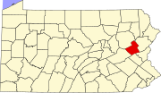
Location of Towamensing Trails in Pennsylvania
Coordinates: 40°59′42″N75°35′0″W / 40.99500°N 75.58333°W / 40.99500; -75.58333
Country United States
State Pennsylvania
County Carbon
Township Penn Forest
Area
  Total6.2 sq mi (16.1 km2)
  Land5.9 sq mi (15.4 km2)
  Water0.3 sq mi (0.7 km2)
Elevation
1,810 ft (550 m)
Population
 (2010)
  Total2,292
  Density386/sq mi (148.9/km2)
Time zone UTC-5 (Eastern (EST))
  Summer (DST) UTC-4 (EDT)
ZIP code
18210 [1]
Area code(s) 272 and 570
FIPS code 42-77163
GNIS feature ID1212327

Towamensing Trails is a census-designated place (CDP) [2] in Penn Forest Township, Pennsylvania, United States. It is part of Northeastern Pennsylvania.

The community is located directly south of Albrightsville in the southern part of the Poconos, bordered by Pennsylvania Route 903 on the northwest, separating it from Albrightsville, and by Pennsylvania Route 534 on the northeast. PA 903 leads southwest 12 miles (19 km) to Jim Thorpe, the Carbon County seat, and north 7 miles (11 km) to Interstate 80 near Blakeslee, while PA 534 leads south 9 miles (14 km) to U.S. Route 209 and west through Hickory Run State Park 14 miles (23 km) to White Haven.

Related Research Articles

<span class="mw-page-title-main">Carbon County, Pennsylvania</span> County in Pennsylvania, United States

Carbon County is a county in the Commonwealth of Pennsylvania. As of the 2020 census, the population was 64,749. The county is part of the Northeast Pennsylvania region of the state.

<span class="mw-page-title-main">Bowmanstown, Pennsylvania</span> Borough in Pennsylvania, United States

Bowmanstown is a borough in Carbon County, Pennsylvania. It is part of Northeastern Pennsylvania. The population was 937 at the 2010 census.

<span class="mw-page-title-main">Franklin Township, Carbon County, Pennsylvania</span> Place in Pennsylvania, United States

Franklin Township is a township in Carbon County, Pennsylvania. It is part of Northeastern Pennsylvania. The population was 4,262 at the 2010 census. A portion of Beltzville State Park is in Franklin Township.

<span class="mw-page-title-main">Kidder Township, Pennsylvania</span> Place in Pennsylvania, United States

Kidder Township is a township in Carbon County, Pennsylvania. It is part of Northeastern Pennsylvania. The population was 1,935 at the 2010 census, up from 1,185 at the 2000 census.

<span class="mw-page-title-main">Penn Forest Township, Pennsylvania</span> Township in Carbon County, United States

Penn Forest Township is a township in Carbon County, Pennsylvania. It is part of Northeastern Pennsylvania. The population was 9,581 at the 2010 census, up from 5,439 at the 2000 census.

<span class="mw-page-title-main">Towamensing Township, Pennsylvania</span> Place in Pennsylvania, United States

Towamensing Township is a lightly populated rural township in eastern Carbon County, Pennsylvania. It is part of Northeastern Pennsylvania.

<span class="mw-page-title-main">New Bethlehem, Pennsylvania</span> Borough in Pennsylvania, United States

New Bethlehem is a borough in Clarion County, Pennsylvania, United States. The population was 979 at the 2020 census. The borough is situated at the southwestern corner of the Pennsylvania Wilds Conservation Landscape. Its main street, PA Route 28-66, is a major thoroughfare between the Pittsburgh metropolitan region and northcentral Pennsylvania. The designated tourism agency for Clarion County is Discover Clarion County

<span class="mw-page-title-main">Mifflinville, Pennsylvania</span> Census-designated place in Pennsylvania, United States

Mifflinville is an unincorporated community and census-designated place (CDP) in Columbia County, Pennsylvania, United States. It is part of Northeastern Pennsylvania. The population was 1,233 at the 2020 census. It is part of the Bloomsburg-Berwick micropolitan area.

<span class="mw-page-title-main">Washington Township, Lehigh County, Pennsylvania</span> Township in Pennsylvania, United States

Washington Township is a township in Lehigh County, Pennsylvania, United States. The population of Washington Township was 6,624 at the 2010 census. It is a suburb of Allentown in the Lehigh Valley, which had a population of 861,899 and was the 68th-most populous metropolitan area in the U.S. as of the 2020 census.

<span class="mw-page-title-main">Polk Township, Monroe County, Pennsylvania</span> Place in Pennsylvania, United States

Polk Township is a township in Monroe County, Pennsylvania, United States. The population was 7,473 at the 2020 census.

<span class="mw-page-title-main">Lehigh Township, Northampton County, Pennsylvania</span> Place in Pennsylvania, United States

Lehigh Township is a township in Northampton County, Pennsylvania, United States. The population of Lehigh Township was 10,526 as of the 2010 census. It is part of the Lehigh Valley metropolitan area, which had a population of 861,899 and was the 68th-most populous metropolitan area in the U.S. as of the 2020 census.

<span class="mw-page-title-main">Moore Township, Pennsylvania</span> Place in Pennsylvania, United States

Moore Township is a township in Northampton County, Pennsylvania, United States. The population of Moore Township was 9,198 at the 2010 census. The township is located in the Lehigh Valley, which had a population of 861,899 and was the 68th-most populous metropolitan area in the U.S. as of the 2020 census.

Brownstown is an unincorporated community and census-designated place (CDP) in West Earl Township, Lancaster County, Pennsylvania, United States. As of the 2010 census, the population was 2,816.

<span class="mw-page-title-main">Smoketown, Pennsylvania</span> Census-designated place in Pennsylvania, United States

Smoketown is an unincorporated village and census-designated place (CDP) in East Lampeter Township, Lancaster County, Pennsylvania, United States. Also known as Smoke Town, it is served by the Smoketown Airport. As of the 2010 census, it had a population of 357.

<span class="mw-page-title-main">Pennsylvania Route 534</span> State highway in Pennsylvania, US

Pennsylvania Route 534 is an 23.5-mile-long (37.8 km) state highway located in Monroe and Carbon counties in Pennsylvania. The western terminus is at PA 940 in East Side. The eastern terminus is at U.S. Route 209 in the community of Kresgeville in Polk Township. PA 534 runs northwest-southeast through forested areas of the Pocono Mountains as a two-lane undivided road. The route has an interchange with Interstate 80 (I-80) near East Side before it passes through Hickory Run State Park. PA 534 crosses PA 903 near Albrightsville and continues south to US 209. The roadway was paved in the 1930s and received the PA 534 designation in the 1960s.

Wakefield is an unincorporated community and census-designated place (CDP) within Fulton Township, Lancaster County, Pennsylvania, United States. As of the 2010 census, the population was 609. It is the largest community within the "Peach Bottom" ZIP code, with the area post office on Pennsylvania Route 272, just north of town.

<span class="mw-page-title-main">Pennsylvania Route 903</span> State highway in Pennsylvania, US

Pennsylvania Route 903 is a 17.7-mile-long (28.5 km) state highway located in Carbon and Monroe counties in Pennsylvania. The southern terminus is at U.S. Route 209 in Jim Thorpe. The northern terminus is at PA 115 in Tunkhannock Township. The route runs through rural areas of the Pocono Mountains, with an interchange with the Pennsylvania Turnpike Northeast Extension in Penn Forest Township and a junction with PA 534 in Kidder Township. PA 903 is a two-lane undivided road nearly its entire length, besides the I-476 intersection. The route was designated in 1928 between US 209/US 309 in present-day Jim Thorpe, and a connecting road, now PA 115, south of Blakeslee. The highway was fully paved in the 1930s. Between 2008 and 2015, an E-ZPass-only interchange was constructed with I-476.

<span class="mw-page-title-main">Rauchtown, Pennsylvania</span> Census-designated place in Pennsylvania, United States

Rauchtown is a census-designated place in Crawford Township, Clinton County, and a small portion in Limestone Township, Lycoming County, in the U.S. state of Pennsylvania. As of the 2010 census the population was 726.

Albrightsville is an unincorporated community and census-designated place which is located in Kidder and Penn Forest townships, Carbon County, Pennsylvania, United States. It is part of Northeastern Pennsylvania.

Holiday Pocono is a residential community and census-designated place (CDP) in Kidder Township, Pennsylvania, United States. It is part of Northeastern Pennsylvania.

References

  1. "Towamensing Trails PA ZIP Code". zipdatamaps.com. 2023. Retrieved May 13, 2023.
  2. "Decennial Census of Population and Housing by Decades".