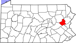
Little Gap, Pennsylvania

Last updated

Little Gap, Pennsylvania
Unincorporated community
USA Pennsylvania location map.svg
Red pog.svg
Little Gap
Usa edcp location map.svg
Red pog.svg
Little Gap
Coordinates: 40°49′58″N75°31′21″W / 40.83278°N 75.52250°W / 40.83278; -75.52250
Country United States
State Pennsylvania
County Carbon
Township Lower Towamensing
Elevation
469 ft (143 m)
Time zone UTC-5 (Eastern (EST))
  Summer (DST) UTC-4 (EDT)
ZIP codes
18038, 18058, 18071
Area code(s) 610 and 484
GNIS feature ID1179552 [1]

Little Gap is a village in eastern Lower Towamensing Township, Carbon County, Pennsylvania on the Aquashicola Creek, which is crossed by a covered bridge, open to vehicular traffic. Blue Mountain Resort is located just to the south of the village, which is split between the Danielsville, Kunkletown, and Palmerton ZIP codes of 18038, 18058, and 18071, respectively.

Related Research Articles

<span class="mw-page-title-main">Diomede Islands</span> Islands between Alaska and Russia

The Diomede Islands, also known in Russia as Gvozdev Islands, consist of two rocky, mesa-like islands:

<span class="mw-page-title-main">Darién Gap</span> Area of largely undeveloped land in Central America

The Darién Gap is a geographic region in the Isthmus of Darien or Isthmus of Panama connecting the American continents within Central America, consisting of a large watershed, forest, and mountains in Panama's Darién Province and the northern portion of Colombia's Chocó Department.

<span class="mw-page-title-main">Cumberland Mountains</span> Mountain range in the southeastern United States

The Cumberland Mountains are a mountain range in the southeastern section of the Appalachian Mountains. They are located in western Virginia, southwestern West Virginia, the eastern edges of Kentucky, and eastern middle Tennessee, including the Crab Orchard Mountains. Their highest peak, with an elevation of 4,223 feet (1,287 m) above mean sea level, is High Knob, which is located near Norton, Virginia.

<span class="mw-page-title-main">Cumberland Gap National Historical Park</span> Historic area in Kentucky, Tennessee, and Virginia, U.S.

The Cumberland Gap National Historical Park is a United States National Historical Park located at the border between Kentucky, Tennessee, and Virginia, centered on the Cumberland Gap, a natural break in the Appalachian Mountains.

Spring Gap Mountain runs southwest northeast through Morgan and Hampshire counties in West Virginia's Eastern Panhandle, rising to its greatest elevation of 2,237 ft (682 m) north of "Spring Gap", from which the mountain takes its name. The gap is the source for Dug Hill Run, a tributary stream of the Little Cacapon River.

<span class="mw-page-title-main">Aldie, Virginia</span> Unincorporated community in Virginia, United States

Aldie is an unincorporated community and census-designated place (CDP) located between Chantilly and Middleburg in Loudoun County, Virginia, United States. The historic village of Aldie is located on the John Mosby Highway in a gap between the Catoctin Mountains and Bull Run Mountains, through which the Little River flows. Aldie traditionally serves as the gateway to the Loudoun Valley and beyond.

Little Washington is a now mostly uninhabited African American village in Loudoun County, Virginia, United States.

Arcola is a census-designated place in Loudoun County, Virginia, United States. The population as of the 2010 United States Census was 233.

Rittenhouse Gap is the name of a village in Longswamp Township in Berks County, Pennsylvania, United States, situated at 40°28′04″N75°37′47″W.

<span class="mw-page-title-main">Spruce Creek, Pennsylvania</span> Unincorporated community in Pennsylvania, United States

Spruce Creek is an unincorporated community in Spruce Creek Township, Huntingdon County, Pennsylvania, United States. It was a stop on the former Pennsylvania Railroad Main Line, lying along Spruce Creek at its confluence with the Little Juniata River. The river passes through a nearby water gap in Tussey Mountain downstream of the village, along with the railroad line.

<span class="mw-page-title-main">Roan Mountain (Roan Highlands)</span>

Roan Mountain is a 6,285 ft (1,916 m) mountain straddling the North Carolina/Tennessee border in the Unaka Range of the Southern Appalachian Mountains in the Southeastern United States. The range's highpoint, Roan is clad in a dense stand of Southern Appalachian spruce-fir forest, and includes the world's largest natural rhododendron garden, and the longest stretch of grassy bald in the Appalachian range. The Roan Highlands also contain the highest quality remaining stretch of Fraser fir forest throughout the tree's entire range. The Cherokee National Forest and Pisgah National Forest converge atop the mountain, with Roan Mountain State Park located near its northern base. The Appalachian Trail traverses most of the Roan's crest. The Roan High Knob Shelter is the highest back-country shelter on the entire 2,174-mile (3,499 km) trail.

<span class="mw-page-title-main">Traverse Gap</span> River channel in Minnesota, US

The Traverse Gap is an ancient river channel occupied by Lake Traverse, Big Stone Lake and the valley connecting them at Browns Valley, Minnesota. It is located on the border of the U.S. states of Minnesota and South Dakota. Traverse Gap has an unusual distinction for a valley: it is crossed by a continental divide, and in some floods water has flowed across that divide from one drainage basin to the other. Before the Anglo-American Convention of 1818 it marked the border between British territory in the north and U.S. – or earlier, French – territory in the south.

<span class="mw-page-title-main">Woody's Knob</span>

Woody's Knob, at an elevation of 4,170 feet, is a summit or "knob" in the Blue Ridge Mountains and one of the highest points in the unincorporated village of Little Switzerland and in Mitchell County, North Carolina.

<span class="mw-page-title-main">Citico Creek Wilderness</span> Wilderness area in Tennessee, U.S.

Citico Creek Wilderness is a 16,226-acre (66 km2) wilderness area within the Cherokee National Forest in the U.S. state of Tennessee. The wilderness contains the entire upper drainage of Citico Creek, which consists of the north and south forks and at least eight tributaries. Three steep-sided ridges descend west from the crest of the Unicoi Mountains — Brush Mountain, Pine Ridge, and Sassafras Ridge.

Gap Broadcasting Group was a group of companies that owned around 116 broadcast stations in 23 radio markets in northwestern and central southern United States in the late 2000s. Managed by Oaktree Capital Management, the group acquired mainly stations from Clear Channel Communications in the mid-sized radio markets that Clear Channel was exiting. All Gap Broadcasting Group stations were acquired by Oaktree's Townsquare Media in August 2010.

United States v. Bormes, 568 U.S. 6 (2012), is a decision by the Supreme Court of the United States holding that the Little Tucker Act, which provides jurisdiction to federal courts for certain claims brought against the federal government, does not apply to lawsuits brought under the Fair Credit Reporting Act (FCRA).

<span class="mw-page-title-main">Mill Gap, Virginia</span> Unincorporated community in Virginia, United States

Mill Gap is an unincorporated community and small rural village in Highland County, Virginia, United States. Mill Gap is located 9.1 miles (14.6 km) southwest of Monterey, Virginia on Virginia State Route 84. The community is located near a water gap of the same name that separates the ridges of Lantz Mountain and Little Mountain through which the East Back Creek flows. As of 2015, the community consists only of a general store and a church, with attached residences.

<span class="mw-page-title-main">Soco Gap</span>

Soco Gap is a mountain pass between the Plott Balsam Range, to its south, and the Balsam Mountains, to its north. Also known as Ahalunun'yi (ᎠᎭᎷᏄn'Ᏹ), meaning "Ambush Place" or Uni'halu'na (ᎤᏂ'ᎭᎷ'Ꮎ), meaning "where they ambushed;" named after the occasion, probably in the mid 1700s, when the Cherokees ambushed a party of invading Shawnees, all of which were killed except for one, who was sent back to tell his people of the Cherokee victory.

<span class="mw-page-title-main">Buck Creek Gap</span>

Buck Creek Gap is a mountain pass along the Blue Ridge Mountains. NC 80 connects with the Blue Ridge Parkway at the gap, where it travelers can go either towards Burnsville, Marion, Mount Mitchell or Little Switzerland. A scenic overlook is located at the gap, along NC 80; which is sometimes also used as a staging area for motorcycle enthusiasts. The gap is also along the Eastern Continental Divide and the McDowell–Yancey county line.

<span class="mw-page-title-main">Gillespie Gap</span> Mountain Pass

Gillespie Gap, also known as Etchoe Pass, is a mountain pass along the Blue Ridge Mountains. Historically, two events occurred at the pass. The first was in 1761 when thirty men, under the command of Francis Marion, were sent to dislodge an encampment of Cherokee warriors at the pass; ambushed, Marion lost twenty-one men. The second was in 1780 when the Overmountain Men crossed the pass on their way to Kings Mountain.

References

  1. "Little Gap". Geographic Names Information System . United States Geological Survey, United States Department of the Interior.