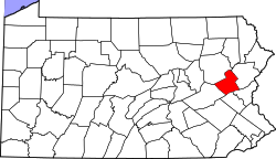
Indian Mountain Lake, Pennsylvania

Last updated

Indian Mountain Lake, Pennsylvania
USA Pennsylvania location map.svg
Red pog.svg
Indian Mountain Lake
Location in Pennsylvania
Usa edcp location map.svg
Red pog.svg
Indian Mountain Lake
Indian Mountain Lake (the United States)
Coordinates: 41°0′18″N75°30′11″W / 41.00500°N 75.50306°W / 41.00500; -75.50306
Country United States
State Pennsylvania
Counties Carbon, Monroe
Townships Penn Forest, Tunkhannock, Chestnuthill
Area
[1]
  Total6.46 sq mi (16.73 km2)
  Land6.37 sq mi (16.50 km2)
  Water0.09 sq mi (0.23 km2)
Elevation
1,785 ft (544 m)
Population
 (2020) [2]
  Total4,733
  Density742.78/sq mi (286.79/km2)
Time zone UTC-5 (Eastern (EST))
  Summer (DST) UTC-4 (EDT)
Area code(s) 570 & 272
FIPS code 42-36904
GNIS feature ID2633697

Indian Mountain Lake is a census-designated place (CDP) [3] in Carbon County and Monroe County, Pennsylvania. It is part of Northeastern Pennsylvania.

Contents

The Carbon County portion of the CDP is located in Penn Forest Township, while the Monroe County portion is in Tunkhannock and Chestnuthill townships. As of the 2020 census, the population of the community was 4,733. [4] There are 3,262 single-family residential building lots in the community as of 2020 records. [5]

History and geography

The community of Indian Mountain Lake lies at the southern edge of the Poconos, on top of Pohopoco Mountain and extending north to the valley of Mud Run, which is impounded to form the small Indian Mountain Lake. The western edge of the CDP follows Pennsylvania Route 534, and Pennsylvania Route 115 crosses the eastern side of the community. Interstate 80 is 7 miles (11 km) to the northwest via PA 115, and Brodheadsville on U.S. Route 209 is 8 miles (13 km) to the south.

Historical population
CensusPop.Note
2010 4,372
2020 4,7338.3%
U.S. Decennial Census [6] [7] [8]

Education

Within Monroe County, the Tunkhannock Township part is in the Pocono Mountain School District. The Chestnuthill Township part is in the Pleasant Valley School District. [9]

The Carbon County portion is in Jim Thorpe Area School District. [10]

Related Research Articles

<span class="mw-page-title-main">Wyoming County, Pennsylvania</span> County in Pennsylvania, United States

Wyoming County is a county in the Commonwealth of Pennsylvania. As of the 2020 census, the population was 26,069. Its county seat is Tunkhannock. It was created in 1842 from part of Luzerne County. The county is part of the Northeast Pennsylvania region of the state.

<span class="mw-page-title-main">Monroe County, Pennsylvania</span> County in Pennsylvania, United States

Monroe County is a county in the Commonwealth of Pennsylvania. As of the 2020 census, the population was 168,327. Its county seat is Stroudsburg. The county is part of the Northeast Pennsylvania region of the state. The county was formed from sections of Northampton and Pike counties on April 1, 1836. It was named in honor of James Monroe, the fifth president of the United States. The county borders Northampton County and the Lehigh Valley to its south, Pike and Wayne counties to its north, Carbon and Luzerne counties to its west, and the Delaware River and Warren County, New Jersey to its east. It is part of the New York metropolitan area, but also receives media from the Scranton/Wilkes-Barre and Philadelphia radio and television markets.

<span class="mw-page-title-main">Carbon County, Pennsylvania</span> County in Pennsylvania, United States

Carbon County is a county in the Commonwealth of Pennsylvania. As of the 2020 census, the population was 64,749. The county is part of the Northeast Pennsylvania region of the state.

<span class="mw-page-title-main">Copake Lake, New York</span> Census-designated place in New York, United States

Copake Lake is a community in southern Columbia County, New York, United States. The population was 767 at the 2020 census.

<span class="mw-page-title-main">Mariaville Lake, New York</span> Census-designated place in New York, United States

Mariaville Lake is a census-designated place (CDP) in Schenectady County, New York. The population was 666 at the 2020 census.

<span class="mw-page-title-main">Kidder Township, Pennsylvania</span> Place in Pennsylvania, United States

Kidder Township is a township in Carbon County, Pennsylvania. It is part of Northeastern Pennsylvania. The population was 1,935 at the 2010 census, up from 1,185 at the 2000 census.

<span class="mw-page-title-main">Penn Forest Township, Pennsylvania</span> Township in Carbon County, United States

Penn Forest Township is a township in Carbon County, Pennsylvania. It is part of Northeastern Pennsylvania. The population was 9,581 at the 2010 census, up from 5,439 at the 2000 census.

<span class="mw-page-title-main">Moscow, Pennsylvania</span> Borough in Pennsylvania, United States

Moscow is a borough in Lackawanna County, Pennsylvania, United States. The population was 2,039 at the 2020 census. It is located 11 miles (18 km) southeast of Scranton and 24 miles (39 km) southwest of Honesdale.

<span class="mw-page-title-main">Barrett Township, Pennsylvania</span> Place in Pennsylvania, United States

Barrett Township is a township in Monroe County, Pennsylvania, United States. The population was 4,053 at the 2020 census. Two Poconos resort communities, Buck Hill Falls and Skytop, are located within the township. It is located 38 miles from Scranton and 48 miles from Wilkes-Barre. There is one privately owned, public-use airport in Barrett Township, called the Flying Dollar Airport.

<span class="mw-page-title-main">Coolbaugh Township, Pennsylvania</span> Place in Pennsylvania, United States

Coolbaugh Township is a township in Monroe County, Pennsylvania, United States. The population was 20,805 at the 2020 census. Tobyhanna State Park is in Coolbaugh Township. Tobyhanna, an unincorporated community, is also located in Coolbaugh Township rather than Tobyhanna Township.

<span class="mw-page-title-main">Pocono Pines, Pennsylvania</span> Census-designated place in Pennsylvania, United States

Pocono Pines is a census-designated place (CDP) in Monroe County, Pennsylvania. The population in the 2020 United States Census was 2,007, an increase over the 1,409 population at the 2010 census.

<span class="mw-page-title-main">Tobyhanna Township, Pennsylvania</span> Place in Pennsylvania, United States

Tobyhanna Township is a township in Monroe County, Pennsylvania, United States. The population was 8,290 at the 2020 census. Tobyhanna Township has Tobyhanna Elementary Center and Locust Lake Village.

<span class="mw-page-title-main">Lehigh Township, Wayne County, Pennsylvania</span> Township in Pennsylvania, United States

Lehigh Township is a second-class township in Wayne County, Pennsylvania. The township's population at the 2020 United States Census was 1,876, down slightly from 1,881 at the time of the 2010 United States Census.

<span class="mw-page-title-main">Roslyn, Pennsylvania</span> Census-designated place in Pennsylvania, United States

Roslyn is an unincorporated community and census-designated place in Montgomery County, Pennsylvania, United States. It is mostly in Abington Township, and extends into Upper Dublin Township as of 2020. Originally called Hillside, the name Roslyn came from rose gardens that once grew there.

<span class="mw-page-title-main">Gouldsboro, Pennsylvania</span> Village in Pennsylvania, United States

Gouldsboro is a village and census-designated place (CDP) in Lehigh Township in Wayne County, and Coolbaugh Township, in Monroe County, Pennsylvania, United States. The CDP's population was 750 at time of the 2020 United States Census.

Emerald Lakes is a census-designated place located in Tobyhanna and Tunkhannock Townships in Monroe County in the state of Pennsylvania. The community is located near Interstates 80 and 380. As of the 2022 American Community Survey, Emerald Lakes was estimated to have 3,228 residents.

Penn Estates is a census-designated place located in Stroud and Pocono Townships in Monroe County in the state of Pennsylvania. The community is located northwest of the borough of East Stroudsburg. As of the 2020 census the population was 4,493 residents.

<span class="mw-page-title-main">Saw Creek, Pennsylvania</span> Census-designated place in Pennsylvania, United States

Saw Creek is a census-designated place and Private community located mainly in Lehman Township in Pike County, Pennsylvania, United States, as well as a small portion located in Middle Smithfield Township in Monroe County in Pennsylvania. As of the 2010 census the population was 4,016 residents.

Sierra View is a census-designated place that is located in Chestnuthill and Tunkhannock Townships in Monroe County in the state of Pennsylvania.

McKinley is an census-designated place, in Montgomery County, Pennsylvania, United States. Almost all of it is in Abington Township, while some blocks are in Cheltenham Township. McKinley is located along Forrest Avenue between Pennsylvania Route 73 and Jenkintown Road southeast of Jenkintown. As of the 2020 United States census the community had a population of 3,128.

References

  1. "ArcGIS REST Services Directory". United States Census Bureau. Retrieved October 12, 2022.
  2. "Census Population API". United States Census Bureau. Retrieved October 12, 2022.
  3. "2010 U.S. Census website". United States Census Bureau . Retrieved February 13, 2016.
  4. US Census Bureau, 2020 Census Report, Indian Mountain Lakes CDP, Pennsylvania Profile https://www.census.gov/search-results.html?searchType=web&cssp=SERP&q=Indian%20Mountain%20Lake%20CDP,%20Pennsylvania
  5. "Indian Mountain Lake - IMLCA - Home". imlca.nabrnetwork.com. Retrieved May 28, 2020.
  6. "Census of Population and Housing". Census.gov. Retrieved June 4, 2016.
  7. "Geographic Identifiers: 2010 Census Summary File 1 (G001): Indian Mountain Lake CDP, Pennsylvania". U.S. Census Bureau, American Factfinder. Archived from the original on April 8, 2015. Retrieved April 8, 2015.
  8. US Census Bureau, 2020 Census Report, Indian Mountain Lakes CDP, Pennsylvania Profile https://www.census.gov/search-results.html?searchType=web&cssp=SERP&q=Indian%20Mountain%20Lake%20CDP,%20Pennsylvania
  9. "2020 CENSUS - SCHOOL DISTRICT REFERENCE MAP: Monroe County, PA" (PDF). U.S. Census Bureau . Retrieved October 30, 2024. - Text list
  10. "2020 CENSUS - SCHOOL DISTRICT REFERENCE MAP: Carbon County, PA" (PDF). U.S. Census Bureau . Retrieved October 30, 2024. - Text list