Middle Smithfield Township, Pennsylvania

Last updated

Middle Smithfield Township
Resica Falls.jpg
Resica Falls in Middle Smithfield Township
Middle Smithfield Seal.png
Monroe County Pennsylvania Incorporated Middle Smithfield Township Highlighted.svg
Pennsylvania in United States (US48).svg
Location of Pennsylvania in the United States
Coordinates: 41°05′00″N74°59′35″W / 41.08333°N 74.99306°W / 41.08333; -74.99306
CountryUnited States
StatePennsylvania
County Monroe
Area
[1]
  Total54.23 sq mi (140.46 km2)
  Land53.16 sq mi (137.68 km2)
  Water1.07 sq mi (2.78 km2)
Elevation
636 ft (194 m)
Population
 (2020) [2]
  Total16,014 Increase2.svg
  Estimate 
(2021) [2]
16,107
  Density294.34/sq mi (113.65/km2)
Time zone UTC-5 (EST)
  Summer (DST) UTC-4 (EDT)
Area code 570
FIPS code 42-089-49080
Website www.middlesmithfieldtownship.com

Middle Smithfield Township is a township in Monroe County, Pennsylvania, United States. The population was 16,014 at the 2020 census. [2]

Contents

History

The Cold Spring Farm Springhouse, John Michael Farm, Schoonover Mountain House, Capt. Jacob Shoemaker House, John Turn Farm, Zion Lutheran Church are located in Delaware Water Gap National Recreation Area at Middle Smithfield Township and listed on the National Register of Historic Places. [3]

Geography

According to the U.S. Census Bureau, the township has a total area of 54.2 square miles (140.2 km2), of which 53.1 square miles (137.6 km2) is land and 1.0 square mile (2.6 km2) (1.88%) is water.

Demographics

Historical population
CensusPop.Note
2000 11,495
2010 15,99739.2%
2020 16,0140.1%
2021 (est.)16,107 [2] 0.6%
U.S. Decennial Census [4]

As of the census [5] of 2000, there were 11,495 people, 3,973 households, and 3,031 families residing in the township. The population density was 216.3 inhabitants per square mile (83.5/km2). There were 6,021 housing units at an average density of 113.3 per square mile (43.7/km2). The racial makeup of the township was 85.24% White, 7.66% African American, 0.22% Native American, 1.31% Asian, 0.01% Pacific Islander, 3.18% from other races, and 2.38% from two or more races. Hispanic or Latino of any race were 8.61% of the population.

There were 3,973 households, out of which 42.8% had children under the age of 18 living with them, 63.4% were married couples living together, 7.9% had a female householder with no husband present, and 23.7% were non-families. 17.6% of all households were made up of individuals, and 5.5% had someone living alone who was 65 years of age or older. The average household size was 2.89 and the average family size was 3.29.

In the township the population was spread out, with 30.9% under the age of 18, 6.1% from 18 to 24, 32.3% from 25 to 44, 21.8% from 45 to 64, and 9.0% who were 65 years of age or older. The median age was 36 years. For every 100 females, there were 102.6 males. For every 100 females age 18 and over, there were 98.9 males.

The median income for a household in the township was $50,435, and the median income for a family was $54,821. Males had a median income of $40,852 versus $27,868 for females. The per capita income for the township was $20,235. About 2.8% of families and 4.5% of the population were below the poverty line, including 4.8% of those under age 18 and 6.1% of those age 65 or over.

Climate

According to the Trewartha climate classification system, Middle Smithfield Township has a Temperate Continental climate (Dc) with warm summers (b), cold winters (o) and year-around precipitation (Dcbo). Dcbo climates are characterized by at least one month having an average mean temperature ≤ 32.0 °F (0 °C), four to seven months with an average mean temperature ≥ 50.0 °F (10 °C), all months with an average mean temperature < 72.0 °F (22 °C) and no significant precipitation difference between seasons. Although most summer days are comfortably humid in Middle Smithfield Township, episodes of heat and high humidity can occur with heat index values > 97 °F (36 °C). Since 1981, the highest air temperature was 97.9 °F (37 °C) on July 22, 2011, and the highest daily average mean dew point was 71.6 °F (22 °C) on August 28, 2018. July is the peak month for thunderstorm activity, which correlates with the average warmest month of the year. The average wettest month is September, which correlates with tropical storm remnants during the peak of the Atlantic hurricane season. Since 1981, the wettest calendar day was 5.87 inches (149 mm) on October 8, 2005. During the winter months, the plant hardiness zone is 6a, with an average annual extreme minimum air temperature of −8.9 °F (−23 °C). [6] Since 1981, the coldest air temperature was −21.2 °F (−30 °C) on January 21, 1994. Episodes of extreme cold and wind can occur with wind chill values < −21 °F (−29 °C). The average snowiest month is January, which correlates with the average coldest month of the year. Ice storms and large snowstorms depositing ≥ 12 inches (30 cm) of snow occur once every couple of years, particularly during nor’easters from December through March.

Climate data for Middle Smithfield Twp, Elevation 932 ft (284 m), 1981-2010 normals, extremes 1981-2018
MonthJanFebMarAprMayJunJulAugSepOctNovDecYear
Record high °F (°C)66.4
(19.1)
75.0
(23.9)
84.6
(29.2)
92.0
(33.3)
93.3
(34.1)
93.2
(34.0)
97.9
(36.6)
96.4
(35.8)
94.7
(34.8)
86.4
(30.2)
77.5
(25.3)
69.6
(20.9)
97.9
(36.6)
Average high °F (°C)34.1
(1.2)
37.8
(3.2)
46.5
(8.1)
59.4
(15.2)
70.0
(21.1)
77.9
(25.5)
81.5
(27.5)
80.4
(26.9)
73.2
(22.9)
61.8
(16.6)
50.4
(10.2)
38.4
(3.6)
59.4
(15.2)
Daily mean °F (°C)24.7
(−4.1)
27.8
(−2.3)
35.8
(2.1)
47.3
(8.5)
57.5
(14.2)
66.1
(18.9)
70.3
(21.3)
69.2
(20.7)
61.9
(16.6)
50.3
(10.2)
40.5
(4.7)
29.8
(−1.2)
48.5
(9.2)
Average low °F (°C)15.3
(−9.3)
17.7
(−7.9)
25.0
(−3.9)
35.1
(1.7)
44.9
(7.2)
54.4
(12.4)
59.0
(15.0)
57.9
(14.4)
50.5
(10.3)
38.7
(3.7)
30.7
(−0.7)
21.2
(−6.0)
37.6
(3.1)
Record low °F (°C)−21.2
(−29.6)
−11.4
(−24.1)
−2.8
(−19.3)
12.6
(−10.8)
27.4
(−2.6)
34.7
(1.5)
40.9
(4.9)
36.6
(2.6)
29.3
(−1.5)
18.4
(−7.6)
2.7
(−16.3)
−9.8
(−23.2)
−21.2
(−29.6)
Average precipitation inches (mm)3.35
(85)
2.93
(74)
3.65
(93)
4.10
(104)
4.36
(111)
4.58
(116)
4.28
(109)
4.31
(109)
4.80
(122)
4.59
(117)
3.83
(97)
3.89
(99)
48.67
(1,236)
Average snowfall inches (cm)13.4
(34)
9.6
(24)
10.0
(25)
2.4
(6.1)
0.0
(0.0)
0.0
(0.0)
0.0
(0.0)
0.0
(0.0)
0.0
(0.0)
0.1
(0.25)
2.5
(6.4)
8.0
(20)
45.9
(117)
Average relative humidity (%)70.965.161.157.460.969.769.672.373.470.669.872.167.7
Average dew point °F (°C)16.6
(−8.6)
17.6
(−8.0)
23.7
(−4.6)
33.0
(0.6)
44.1
(6.7)
55.9
(13.3)
59.9
(15.5)
59.9
(15.5)
53.3
(11.8)
41.1
(5.1)
31.4
(−0.3)
21.9
(−5.6)
38.3
(3.5)
Source: PRISM [7]

Transportation

US Route 209 northbound in Middle Smithfield Township 2022-08-08 18 40 36 View north along U.S. Route 209 (Milford Road) at Oak Grove Road and Mount Nebo Road in Middle Smithfield Township, Monroe County, Pennsylvania.jpg
US Route 209 northbound in Middle Smithfield Township

As of 2020, there were 105.44 miles (169.69 km) of public roads in Middle Smithfield Township, of which 30.56 miles (49.18 km) were maintained by the Pennsylvania Department of Transportation (PennDOT) and 74.88 miles (120.51 km) were maintained by the township. [8]

U.S. Route 209 and Pennsylvania Route 402 are the numbered highways serving Middle Smithfield Township. US 209 follows Milford Road along a southwest-northeast alignment across the southeastern portion of the township. PA 402 follows Resica Falls Road along a north-south alignment through the middle of the township.

Ecology

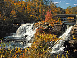
According to the A. W. Kuchler U.S. potential natural vegetation types, Middle Smithfield Township would have a dominant vegetation type of Appalachian Oak (104) with a dominant vegetation form of Eastern Hardwood Forest (25). [9] The peak spring bloom typically occurs in late-April and peak fall color usually occurs in mid-October. The plant hardiness zone is 6a with an average annual extreme minimum air temperature of −8.9 °F (−23 °C). [6]

Related Research Articles

<span class="mw-page-title-main">Southern Shores, North Carolina</span> Town in North Carolina, United States

Southern Shores is a town in Dare County, North Carolina, United States. It is located on the Outer Banks and the population was 3,107 at the 2020 census.

<span class="mw-page-title-main">Haycock Township, Bucks County, Pennsylvania</span> Township in Pennsylvania, United States

Haycock Township is a township in Bucks County, Pennsylvania, United States. The population was 2,225 at the 2010 census.

<span class="mw-page-title-main">Lower Southampton Township, Bucks County, Pennsylvania</span> Township in Pennsylvania, United States

Lower Southampton Township is a township in Bucks County, Pennsylvania, United States. The population was 20,599 at the 2020 census.

<span class="mw-page-title-main">Nockamixon Township, Pennsylvania</span> Township in Pennsylvania, United States

Nockamixon Township is a township in Bucks County, Pennsylvania, United States. The population was 3,441 at the 2010 census.

<span class="mw-page-title-main">Richland Township, Bucks County, Pennsylvania</span> Township in Pennsylvania, United States

Richland Township is a township in Bucks County, Pennsylvania, United States. The population was 11,100 at the 2010 census.

<span class="mw-page-title-main">Barrett Township, Pennsylvania</span> Place in Pennsylvania, United States

Barrett Township is a township in Monroe County, Pennsylvania, United States. The population was 4,053 at the 2020 census. Two Poconos resort communities, Buck Hill Falls and Skytop, are located within the township. It is located 38 miles from Scranton and 48 miles from Wilkes-Barre. There is one privately owned, public-use airport in Barrett Township, called the Flying Dollar Airport.

<span class="mw-page-title-main">Chestnuthill Township, Monroe County, Pennsylvania</span> Place in Pennsylvania, United States

Chestnuthill Township is a township in Monroe County, Pennsylvania, United States. The population was 16,708 at the 2020 census.

<span class="mw-page-title-main">Coolbaugh Township, Monroe County, Pennsylvania</span> Place in Pennsylvania, United States

Coolbaugh Township is a township in Monroe County, Pennsylvania, United States. The population was 20,805 at the 2020 census. Tobyhanna State Park is in Coolbaugh Township. Tobyhanna, an unincorporated community, is also located in Coolbaugh Township rather than Tobyhanna Township.

<span class="mw-page-title-main">Eldred Township, Monroe County, Pennsylvania</span> Township in Pennsylvania, United States

Eldred Township is a township in Monroe County, Pennsylvania, United States. The population was 2,594 at the 2020 census.

<span class="mw-page-title-main">Hamilton Township, Monroe County, Pennsylvania</span> Place in Pennsylvania, United States

Hamilton Township is a township in Monroe County, Pennsylvania, United States. The population was 8,635 at the 2020 census.

<span class="mw-page-title-main">Jackson Township, Monroe County, Pennsylvania</span> Place in Pennsylvania, United States

Jackson Township is a township in Monroe County, Pennsylvania, United States. The population was 6,561 at the 2020 census. A portion of Big Pocono State Park a Pennsylvania state park is on Camelback Mountain in Jackson Township.

<span class="mw-page-title-main">Paradise Township, Monroe County, Pennsylvania</span> Place in Pennsylvania, United States

Paradise Township is a township in Monroe County, Pennsylvania in the Pocono Mountains. The population was 2,898 at the 2020 census.

<span class="mw-page-title-main">Pocono Township, Pennsylvania</span> Place in Pennsylvania, United States

Pocono Township is a township in Monroe County, Pennsylvania. The township's government is located in the village of Tannersville, Pennsylvania, near the site of Camelback Mountain Resort, which is located in the Pocono Mountains and the adjacent Jackson Township. The top of the ski area is within Big Pocono State Park, which is maintained by resort staff. The population was 10,868 at the 2020 census.

<span class="mw-page-title-main">Polk Township, Monroe County, Pennsylvania</span> Place in Pennsylvania, United States

Polk Township is a township in Monroe County, Pennsylvania, United States. The population was 7,473 at the 2020 census.

<span class="mw-page-title-main">Price Township, Pennsylvania</span> Place in Pennsylvania, United States

Price Township is a township in Monroe County, Pennsylvania, United States. The population was 3,675 at the 2020 census.

<span class="mw-page-title-main">Ross Township, Monroe County, Pennsylvania</span> Township in Pennsylvania, United States

Ross Township is a township in Monroe County, Pennsylvania, United States. The population was 5,464 at the 2020 census. Ross Township is one of 16 townships in Monroe County.

<span class="mw-page-title-main">Smithfield Township, Monroe County, Pennsylvania</span> Place in Pennsylvania, United States

Smithfield Township is a township in Monroe County, Pennsylvania, United States. The population was 8,001 at the 2020 census.

<span class="mw-page-title-main">Stroud Township, Pennsylvania</span> Place in Pennsylvania, United States

Stroud Township is a township in Monroe County, Pennsylvania, United States. As of 2020, the township had an estimated population of 19,812.

<span class="mw-page-title-main">Tunkhannock Township, Monroe County, Pennsylvania</span> Township in Pennsylvania, United States

Tunkhannock Township is a township in Monroe County, Pennsylvania, United States. The population was 7,037 at the 2020 census. Tunkhannock Township comprises the communities of Blakeslee and Long Pond. The most noteworthy feature of this township is the Tunkhannock creek, which forms "Long Pond", and is designated by the PA DEP as an Exceptional Value Waters (EV). The Bethlehem Authority, Nature Conservancy, Wildlands Conservancy County of Monroe Open Space Program, and PA Department of Forest and Waters have protected thousands of acres. Tunkhannock Township, PA is home to many species of globally rare, threatened, and endangered plants and animals and has been described as one of the last "great places".

<span class="mw-page-title-main">Stowe, Vermont</span> Town in Vermont, United States

Stowe is a town in Lamoille County, Vermont, United States. The population was 5,223 at the 2020 census. The town lies on Vermont Routes 108 and 100. It is nicknamed "The Ski Capital of the East" and is home to Stowe Mountain Resort, a ski facility with terrain on Mount Mansfield and Spruce Peak.

References

  1. "2016 U.S. Gazetteer Files". United States Census Bureau. Retrieved August 14, 2017.
  2. 1 2 3 4 Bureau, US Census. "City and Town Population Totals: 2020—2021". Census.gov. US Census Bureau. Retrieved August 6, 2022.
  3. "National Register Information System". National Register of Historic Places . National Park Service. March 13, 2009.
  4. "Census of Population and Housing". Census.gov. Retrieved June 4, 2016.
  5. "U.S. Census website". United States Census Bureau . Retrieved January 31, 2008.
  6. 1 2 "USDA Interactive Plant Hardiness Map". United States Department of Agriculture. Archived from the original on July 4, 2019. Retrieved September 4, 2019.
  7. "PRISM Climate Group, Oregon State University" . Retrieved September 4, 2019.
  8. "Middle Smithfield Township map" (PDF). PennDOT. Retrieved March 15, 2023.
  9. "U.S. Potential Natural Vegetation, Original Kuchler Types, v2.0 (Spatially Adjusted to Correct Geometric Distortions)" . Retrieved September 3, 2019.