
Monroe County is a county in the Commonwealth of Pennsylvania. As of the 2020 census, the population was 168,327. Its county seat is Stroudsburg. The county is part of the Northeast Pennsylvania region of the state. The county was formed from sections of Northampton and Pike counties on April 1, 1836. It was named in honor of James Monroe, the fifth president of the United States. The county borders Northampton County and the Lehigh Valley to its south, Pike and Wayne counties to its north, Carbon and Luzerne counties to its west, and the Delaware River and Warren County, New Jersey to its east. It is part of the New York metropolitan area, but also receives media from the Scranton/Wilkes-Barre and Philadelphia radio and television markets.
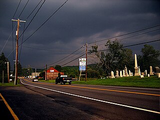
Brodheadsville is a census-designated place (CDP) in Monroe County, Pennsylvania, United States. The population was 1,700 at the 2020 census. The community is served by Pleasant Valley School District.

Chestnuthill Township is a township in Monroe County, Pennsylvania, United States. The population was 16,708 at the 2020 census.

East Stroudsburg is a borough in Monroe County, Pennsylvania, and part of the Pocono Mountains region of the state. Originally known as Dansbury, East Stroudsburg was renamed for geographic reasons when the Delaware, Lackawanna, and Western Railroad opened a station in East Stroudsburg. Despite its name being derivative of its bordering borough, Stroudsburg, it has almost twice the population.

Hamilton Township is a township in Monroe County, Pennsylvania, United States. The population was 8,635 at the 2020 census.

Smithfield Township is a township in Monroe County, Pennsylvania, United States. The population was 8,001 at the 2020 census.

Stroudsburg is a borough in and the county seat of Monroe County, Pennsylvania, United States. It lies within the Poconos region approximately five miles (8 km) from the Delaware Water Gap at the confluence of Brodhead Creek, McMichaels, and Pocono Creeks in Northeastern Pennsylvania. Stroudsburg is part of the East Stroudsburg, PA Metropolitan Statistical Area, which in turn is part of the New York combined statistical area. The population was 5,927 at the 2020 census.

Pennsylvania Route 115 (PA 115) is a 35.7-mile-long (57.5 km) north–south state highway in eastern Pennsylvania. It stretches from U.S. Route 209 (US 209) in Brodheadsville, Monroe County, northwest to Interstate 81 (I-81) and PA 309 near Wilkes-Barre in Luzerne County. PA 115 passes through rural areas along its route, intersecting PA 903 in Tunkhannock Township, I-80 and PA 940 in Tobyhanna Township, and I-476 in Bear Creek Township. The road serves as a connector between the Pocono Mountains and the Wyoming Valley.

Pennsylvania Route 715 (PA 715) is a 17.7-mile-long (28.5 km) north–south state route located entirely in Monroe County, Pennsylvania. Its southern terminus is at U.S. Route 209 (US 209) in the Chestnuthill Township hamlet of Brodheadsville. The northern terminus is at PA 191 in the Paradise Township hamlet of Henryville. PA 715 also intersects Interstate 80 (I-80) in Tannersville at Exit 299. The route is a two-lane undivided road running through forested areas of the Pocono Mountains. The road was paved between 1930 and the 1940s. PA 715 was designated to its present alignment in 1963.

Pennsylvania Route 402 is a 29.24-mile (47.06 km) north–south state route in the Pennsylvania counties of Monroe and Pike. The southern terminus of the route is at U.S. Route 209 Business in the Smithfield Township village of Marshalls Creek. The northern terminus is at US 6 in Palmyra Township.
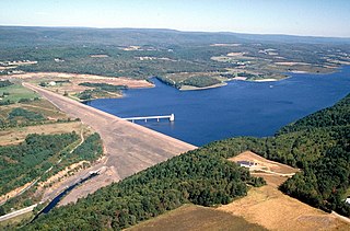
Beltzville State Park is a 2,972.39-acre (1,202.88 ha) Pennsylvania state park in Franklin and Towamensing townships, Carbon County, Pennsylvania in the United States. The park opened in 1972, and was developed around the U.S. Army Corps of Engineers flood control project Beltzville Dam on Pohopoco Creek. The village of Big Creek Valley was vacated in 1966 to make way for Beltzville Lake.

Pennsylvania Route 447 (PA 447) is a 26.66-mile-long (42.91 km) north–south state route located in northeast Pennsylvania in the Pocono Mountains. The southern terminus of the route is at U.S. Route 209 (US 209) near an interchange with Interstate 80 (I-80) in Smithfield Township. The northern terminus is at PA 191 and PA 507 in Dreher Township. The route heads northwest from US 209 in Monroe County and forms a brief concurrency with US 209 Business in the northern part of East Stroudsburg. PA 447 continues and forms a concurrency with PA 191 in Analomink before winding north through rural areas. The route bends northwest and crosses PA 390 in Canadensis. PA 447 passes through a section of Pike County before entering Wayne County and reaching its northern terminus.

Pennsylvania Route 196 is a state highway in the Pocono Mountains of Pennsylvania, United States, with a length of 25.7 miles (41.4 km). It runs from PA 611 and PA 940 in Mount Pocono in Monroe County north to PA 296 in Varden in Wayne County. The route is a two-lane undivided road that runs through rural areas. PA 196 intersects PA 423 near Tobyhanna State Park before entering Wayne County, where it crosses PA 507 in Angels and passes through Sterling. The route forms a concurrency with PA 191 and has a junction with PA 590 in Hamlin. Upon splitting from PA 191, PA 196 continues north to its end at PA 296.

Pennsylvania Route 534 is an 23.5-mile-long (37.8 km) state highway located in Monroe and Carbon counties in Pennsylvania. The western terminus is at PA 940 in East Side. The eastern terminus is at U.S. Route 209 in the community of Kresgeville in Polk Township. PA 534 runs northwest-southeast through forested areas of the Pocono Mountains as a two-lane undivided road. The route has an interchange with Interstate 80 (I-80) near East Side before it passes through Hickory Run State Park. PA 534 crosses PA 903 near Albrightsville and continues south to US 209. The roadway was paved in the 1930s and received the PA 534 designation in the 1960s.

Pennsylvania Route 903 is a 17.7-mile-long (28.5 km) state highway located in Carbon and Monroe counties in Pennsylvania. The southern terminus is at U.S. Route 209 in Jim Thorpe. The northern terminus is at PA 115 in Tunkhannock Township. The route runs through rural areas of the Pocono Mountains, with an interchange with the Pennsylvania Turnpike Northeast Extension in Penn Forest Township and a junction with PA 534 in Kidder Township. PA 903 is a two-lane undivided road nearly its entire length, besides the I-476 intersection. The route was designated in 1928 between US 209/US 309 in present-day Jim Thorpe, and a connecting road, now PA 115, south of Blakeslee. The highway was fully paved in the 1930s. Between 2008 and 2015, an E-ZPass-only interchange was constructed with I-476.

U.S. Route 209 (US 209) is a 211.74-mile (340.76 km) long U.S. Highway in the states of Pennsylvania and New York. Although the route is a spur of US 9, US 209 never intersects US 9, coming within five miles of the route and making the short connection via New York State Route 199 (NY 199). The southern terminus of the route is at Pennsylvania Route 147 (PA 147) in Millersburg, Pennsylvania. The northern terminus is at US 9W north of Kingston in Ulster, New York, where the road continues east as NY 199.
Indian Mountain Lake is a census-designated place (CDP) in Carbon County and Monroe County, Pennsylvania. It is part of Northeastern Pennsylvania.
Hamilton Square is an unincorporated community in Hamilton Township, Monroe County, Pennsylvania, United States. Hamilton Square is located near U.S. Route 209 5.2 miles (8.4 km) east of Brodheadsville.
Snydersville is an unincorporated community in Hamilton Township in Monroe County, Pennsylvania, United States. Snydersville is located at the intersection of U.S. Route 209 Business, Rimrock Road, Pensyl Creek Road, and Middle Easton Belmont Pike.
Sciota Brook is a tributary of North Branch Mehoopany Creek in Bradford County, Sullivan County, and Wyoming County, in Pennsylvania, in the United States. It is approximately 2.0 miles (3.2 km) long and flows through Wilmot Township in Bradford County, Colley Township in Sullivan County, and North Branch Township in Wyoming County. The watershed of the stream has an area of 3.23 square miles (8.4 km2). The stream itself is a moderate-gradient stream in an area consisting primarily of agricultural land and woodlots.


