Reeders, Pennsylvania | |
|---|---|
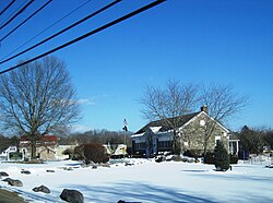 Jackson Township municipal building and Reeders post office within the village | |
 Reeders | |
| Coordinates: 41°1′8″N75°20′10″W / 41.01889°N 75.33611°W | |
| Country | United States |
| State | Pennsylvania |
| County | Monroe |
| Township | Jackson |
| Elevation | 991 ft (302 m) |
| Population (2016) | |
• Total | 1,326 |
| Time zone | UTC-5 (Eastern (EST)) |
| • Summer (DST) | UTC-4 (EDT) |
| ZIP Code | 18352 |
| Area code | 570 |
| GNIS feature ID | 1184826 [1] |
Reeders is an unincorporated community in Jackson Township in Monroe County, Pennsylvania, United States. Reeders is located at the intersection of Pennsylvania Route 715 and Reeders Run Road. [2]
