Pleasant Corners, Carbon County, Pennsylvania

Last updated
Pleasant Corners, Pennsylvania
Unincorporated community
USA Pennsylvania location map.svg
Red pog.svg
Pleasant Corners
Coordinates: 40°48′38″N75°46′46″W / 40.81056°N 75.77944°W / 40.81056; -75.77944 Coordinates: 40°48′38″N75°46′46″W / 40.81056°N 75.77944°W / 40.81056; -75.77944
Country United States
State Pennsylvania
County Carbon
Township Mahoning
Elevation
597 ft (182 m)
Time zone UTC-5 (Eastern (EST))
  Summer (DST) UTC-4 (EDT)
Area code(s) 570 and 272
GNIS feature ID1184004 [1]

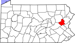
Pleasant Corners is an unincorporated community located in Mahoning Township in Carbon County, Pennsylvania. Pleasant Corners is located on Pennsylvania Route 902 between Normal Square and Lehighton. [2]

Related Research Articles

Carbon County, Pennsylvania County in Pennsylvania, United States

Carbon County is a county located in the U.S. state of Pennsylvania, in the United States. As of the 2020 census, the population was 64,749. The county is also part of Pennsylvania's Coal Region.

Heidelberg Township, Lehigh County, Pennsylvania Township in Pennsylvania, United States

Heidelberg Township is a township in Lehigh County, Pennsylvania, in the United States. It is a suburb of Allentown, Pennsylvania in the Lehigh Valley, which has a population of 861,899 and is the 68th most populated metropolitan area in the U.S. as of the 2020 census.

Mount Pleasant Township, Wayne County, Pennsylvania Second-class township in Pennsylvania, United States

Mount Pleasant is a second-class township in Wayne County, Pennsylvania, United States. The township's population was 1,357 at the time of the 2010 United States Census.

Pennsylvania Route 100 State highway in Pennsylvania, US

Pennsylvania Route 100 is a 59.4-mile (95.6 km) long state highway in the U.S. state of Pennsylvania that runs from U.S. Route 202 near West Chester north to PA 309 in Pleasant Corners. The route runs between the western suburbs of Philadelphia and the Lehigh Valley region of the state, serving Chester, Montgomery, Berks, and Lehigh counties. PA 100 intersects several important highways including US 30 in Exton, the Pennsylvania Turnpike near Lionville, US 422 near Pottstown, US 222 in Trexlertown, and I-78/US 22 in Fogelsville. PA 100 has several sections which are multi-lane divided highway with some interchanges, including between US 202 and the Pennsylvania Turnpike in Chester County, between south of Pottstown and New Berlinville, and between Trexlertown and Fogelsville.

Pleasant Corners can refer to the following unincorporated communities in Pennsylvania:

Pennsylvania Route 309 is a state highway that runs for 134 miles (216 km) through eastern Pennsylvania in the United States. The route runs from the interchange between PA 611 and Cheltenham Avenue on the border of Philadelphia and Cheltenham Township north to an intersection with PA 29 in Bowman Creek, a village in Monroe Township in Wyoming County. The highway connects Philadelphia and its northern suburbs to Allentown and the Lehigh Valley, and Hazleton and Wilkes-Barre in the Wyoming Valley.

Blue Mountain (Pennsylvania) Ridge in Pennsylvania, United States

Blue Mountain, Blue Mountain Ridge, or the Blue Mountains of Pennsylvania is a ridge of the Appalachian Mountains in eastern Pennsylvania. Forming the southern and eastern edge of the Ridge-and-Valley Appalachians physiographic province in Pennsylvania, Blue Mountain extends 150 miles (240 km) from the Delaware Water Gap on the New Jersey border in the east to Big Gap in Franklin County in south-central Pennsylvania at its southwestern end.

Delaware Route 896 State highway in New Castle County, Delaware, United States

Delaware Route 896 (DE 896) is a state highway located in New Castle County, Delaware. The route runs from U.S. Route 13 (US 13) in Boyds Corner north to the Maryland border northwest of Newark, where the road becomes unsigned Maryland Route 896 (MD 896) briefly before heading into Pennsylvania as Pennsylvania Route 896 (PA 896). The route heads west from US 13 before turning north along with DE 71 in Mount Pleasant, crossing the Chesapeake & Delaware Canal on the Summit Bridge. After the bridge, DE 71 splits off to the east and the road continues to Glasgow, where it comes to an intersection with US 40. DE 896 continues north and interchange with Interstate 95 (I-95) before reaching Newark, where it bypasses the University of Delaware to the west by following DE 4, Elkton Road, and South Main Street. DE 896 comes to downtown Newark and continues northwest to the Maryland border. DE 896 has a business route, DE 896 Business, that passes through Glasgow, and had an alternate alignment south of Glasgow called DE 896 Alternate.

Pennsylvania Route 902 is an 11.66-mile-long (18.76 km) east–west state highway in Carbon County in the U.S. state of Pennsylvania. The route runs from U.S. Route 209 in Lansford southeast to PA 443 in Lehighton. The highway is a two-lane undivided road its entire length. From Lansford, PA 902 heads southeast passes through Summit Hill before crossing two mountains and entering the Mahoning Valley. The route turns east at New Mahoning and continues to Lehighton, where it turns south to end at PA 443 in the western part of the borough. The route was designated between US 209 near Summit Hill and New Mahoning in 1928. PA 902 was extended east to US 209/US 309 in the center of Lehighton in the 1930s and rerouted to end at PA 443 in the 1980s.

Pennsylvania Route 534 is an 23.5-mile-long (37.8 km) state highway located in Monroe and Carbon counties in Pennsylvania. The western terminus is at PA 940 in East Side. The eastern terminus is at U.S. Route 209 in the community of Kresgeville in Polk Township. PA 534 runs northwest-southeast through forested areas of the Pocono Mountains as a two-lane undivided road. The route has an interchange with Interstate 80 (I-80) near East Side before it passes through Hickory Run State Park. PA 534 crosses PA 903 near Albrightsville and continues south to US 209. The roadway was paved in the 1930s and received the PA 534 designation in the 1960s.

Pennsylvania Route 670 (PA 670) is a 21.26-mile-long (34.21 km) state highway located in Wayne County, Pennsylvania. The southern terminus is at PA 191 in Honesdale. The northern terminus is at PA 370 in Preston Township. The route is a two-lane undivided road that runs through rural areas in the northern part of Wayne County. PA 670 heads northwest from PA 191 and passes through Bethany. Farther northwest, the route crosses PA 247 and intersects the northern terminus of PA 170 before turning west to run concurrent with PA 371 in Pleasant Mount. PA 670 turns north from PA 371 and continues to its end at PA 370 in Orson.

Pennsylvania House of Representatives, District 39 American legislative district

The 39th Pennsylvania House of Representatives District is located in southwestern Pennsylvania and has been represented since 2018 by Mike Puskaric.

Pennsylvania Route 371 is a 23.5 mi (37.8 km) long state highway located in Susquehanna and Wayne Counties. The western terminus is at an intersection with PA 171 and PA 374 near the community of Union Dale in Herrick Center. The eastern terminus is at the New York state line in Damascus Township where it crosses the Delaware River on the Cochecton–Damascus Bridge. It continues into Sullivan County, New York, as County Route 114 (CR 114), which heads east toward New York State Route 97 (NY 97).

Pennsylvania Route 965 is an 11.6-mile-long (18.7 km) state highway located in Mercer County and Venango County, Pennsylvania. The route terminates at each end at U.S. Route 62. In the west, it begins in Jackson Township, before traveling through rural areas to its end in Frenchcreek Township.

Germansville, Pennsylvania Unincorporated community in Pennsylvania, United States

Germansville is an exurban unincorporated community located in Heidelberg Township in Lehigh County, Pennsylvania, in the United States.

Mount Pleasant is an unincorporated community in Hilltown Township in Bucks County, Pennsylvania, United States. Mount Pleasant is located at the intersection of Pennsylvania Route 152 and Hilltown Pike.

Pleasant Valley, Bucks County, Pennsylvania Unincorporated community in Pennsylvania, United States

Pleasant Valley is an unincorporated community in Springfield Township, Bucks County, Pennsylvania in the United States.

Pleasant Corners is an unincorporated community located in Heidelberg Township in Lehigh County, Pennsylvania, in the United States. Pleasant Corners is located at the intersection of Pennsylvania Route 100 and Pennsylvania Route 309 between New Tripoli and Schnecksville.

Pleasant Hall, Pennsylvania Unincorporated community in Pennsylvania, United States

Pleasant Hall is an unincorporated community in Letterkenny Township in Franklin County, Pennsylvania, United States. Pleasant Hall is located at the intersection of Pennsylvania Route 533 and Pennsylvania Route 997 north of Chambersburg and northeast of the Letterkenny Army Depot.

The Pennsylvania State Game Lands Number 280 are Pennsylvania State Game Lands in Berks County in Pennsylvania in the United States providing hunting, bird watching, and other activities.

References

  1. "Pleasant Corners". Geographic Names Information System . United States Geological Survey.
  2. Carbon County, Pennsylvania Highway Map (PDF) (Map). PennDOT. 2014. Retrieved January 7, 2015.[ permanent dead link ]