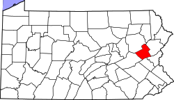
Aquashicola, Pennsylvania

Last updated

Aquashicola, Pennsylvania
Unincorporated community
Aquashicola, PA (3), Feb. 2024.jpg
Westbound along Little Gap Road
USA Pennsylvania location map.svg
Red pog.svg
Aquashicola
Usa edcp location map.svg
Red pog.svg
Aquashicola
Coordinates: 40°48′40″N75°35′25″W / 40.81111°N 75.59028°W / 40.81111; -75.59028
Country United States
State Pennsylvania
County Carbon
Township Lower Towamensing
Elevation
413 ft (126 m)
Time zone UTC-5 (Eastern (EST))
  Summer (DST) UTC-4 (EDT)
ZIP code
18012
Area codes 610 and 484
GNIS feature ID1168357 [1]

Aquashicola (locally pronounced ack-wa-SHIK-la) is an unincorporated community located in Lower Towamensing Township in Carbon County, Pennsylvania. Aquashicola is located at the intersection of Little Gap Road and Forest Inn Road north of the Aquashicola Creek and immediately east of Palmerton. [2]

History

"Aquashicola is an Indian word that means 'Where we fish with the bush nets.' Postal service employees changed the name from Millport to Aquashicola to distinguish it from another Millport in Potter County." "The village was the site of a grist-mill, established in 1806 by George Ziegenfuss Sr. It...remained in use until 1930." "In 1830, a tannery was built along Aquashicola Creek." "The tannery was destroyed by fire in 1874. In 1844, an Evangelical Church was organized. In 1866, the United Methodist Church was formed." [3]

Related Research Articles

<span class="mw-page-title-main">Carbon County, Pennsylvania</span> County in Pennsylvania, United States

Carbon County is a county in the Commonwealth of Pennsylvania. It is located in Northeastern Pennsylvania. As of the 2020 census, the population was 64,749. The county is also part of Pennsylvania's Coal Region.

<span class="mw-page-title-main">Kidder Township, Pennsylvania</span> Place in Pennsylvania, United States

Kidder Township is a township in Carbon County, Pennsylvania. It is part of Northeastern Pennsylvania. The population was 1,935 at the 2010 census, up from 1,185 at the 2000 census.

<span class="mw-page-title-main">Lower Towamensing Township, Pennsylvania</span> Place in Pennsylvania, United States

Lower Towamensing Township is a township in Carbon County, Pennsylvania. It is part of Northeastern Pennsylvania. The Lenape Indian tribe name is eponymous and was once applied by the natives to the whole region of Carbon County and bits of the Poconos to the north and to Schuylkill County (southwest). The population was 3,228 at the 2010 census.

<span class="mw-page-title-main">Towamensing Township, Pennsylvania</span> Place in Pennsylvania, United States

Towamensing Township is a lightly populated rural township in eastern Carbon County, Pennsylvania. It is part of Northeastern Pennsylvania.

<span class="mw-page-title-main">Plunketts Creek Township, Pennsylvania</span> Township in Pennsylvania, United States

Plunketts Creek Township is a township in Lycoming County, Pennsylvania, United States. It includes the villages of Barbours and Proctor. The population was 595 at the 2020 census, down from 684 at the 2010 census. It is part of the Williamsport Metropolitan Statistical Area.

<span class="mw-page-title-main">Pennsylvania Route 248</span> State highway in Pennsylvania, US

Pennsylvania Route 248 is a 31.3 mi (50.4 km) long state highway in the eastern part of the U.S. state of Pennsylvania. The western terminus of the route is at U.S. Route 209 in Weissport East, a CDP in Franklin Township. The eastern terminus is at PA 611 in Easton. The route begins at US 209 in Carbon County and heads southeast parallel to the Lehigh River as a four-lane divided highway to Bowmanstown, where it becomes a freeway and heads through Palmerton. Upon crossing Lehigh Gap in Blue Mountain, PA 248 enters Northampton County and becomes a two-lane undivided highway that heads southeast through rural areas, serving Bath and Nazareth. From here, the route runs southeast through suburban areas to Wilson, where it turns east and follows city streets through Easton.

<span class="mw-page-title-main">Larrys Creek</span> Tributary of the West Branch Susquehanna River

Larrys Creek is a 22.9-mile-long (36.9 km) tributary of the West Branch Susquehanna River in Lycoming County in the U.S. state of Pennsylvania. A part of the Chesapeake Bay drainage basin, its watershed drains 89.1 square miles (231 km2) in six townships and a borough. The creek flows south from the dissected Allegheny Plateau to the Ridge-and-valley Appalachians through sandstone, limestone, and shale from the Devonian, Mississippian, and Pennsylvanian periods.

Aquashicola Creek (Ahkwa-SHIK-ola), also known as Aquanchicola Creek, or Aquanshicola Creek, is a 20.8-mile-long (33.5 km) tributary of the Lehigh River in the Poconos of eastern Pennsylvania in the United States.

<span class="mw-page-title-main">Bowman Creek</span> River

Bowman Creek is a tributary of the Susquehanna River in Luzerne County and Wyoming County, in Pennsylvania, in the United States. It is approximately 26 miles (42 km) long and flows through Ross Township and Lake Township in Luzerne County and Noxen Township, Monroe Township, and Eaton Township in Wyoming County. The watershed of the creek has an area of 120 square miles (310 km2). The creek is not designated as an impaired waterbody and its pH is close to neutral, although it has experienced some problems with acid rain. It has low concentrations of dissolved solids like calcium. The creek is relatively small in its upper reaches, but by Noxen, its width is 40 to 60 feet. It is also relatively shallow in many reaches. Rock formations in the watershed include the Catskill Formation, the Huntley Mountain Formation, Burgoon Sandstone, the Mauch Chunk Formation, the Pottsville Group, and the Pocono Formation. Soil associations in the creek's watershed include the Wellsboro-Morris-Oquaga association, the Oquaga-Lackawanna-Arnot association, the Mardin-Bath-Volusia association, and the Wyoming-Pope association.

<span class="mw-page-title-main">Tobyhanna State Park</span>

Tobyhanna State Park is a Pennsylvania state park on 5,440 acres (2,201 ha) mostly in Coolbaugh Township, Monroe County, with a small portion of the park in Dreher and Lehigh townships in Wayne County, all in Pennsylvania in the United States. The park includes the 170-acre (69 ha) Tobyhanna Lake and a portion of Tobyhanna Creek. It is located 2.1 miles (3.4 km) north of the town of Tobyhanna, with the main park entrance on Pennsylvania Route 423, and a portion that borders on Pennsylvania Route 196. The park lies immediately adjacent to Gouldsboro State Park, Pennsylvania State Game Lands 312, and State Game Land 127.

<span class="mw-page-title-main">Lehigh Gorge State Park</span>

Lehigh Gorge State Park is a 4,548 acres (1,841 ha) Pennsylvania state park in Luzerne and Carbon Counties, Pennsylvania. The park encompasses a gorge, which stretches along the Lehigh River from a U.S. Army Corps of Engineers flood control dam in Luzerne County to Jim Thorpe in Carbon County.

<span class="mw-page-title-main">Little Fishing Creek</span> Creek in Columbia County, Pennsylvania

Little Fishing Creek is a tributary of Fishing Creek in Sullivan County, Lycoming County, and Columbia County, in Pennsylvania, in the United States. It is approximately 23.5 miles (37.8 km) long and flows through eight townships. The watershed of the creek has an area of 68.1 square miles (176 km2). The creek has six named tributaries, of which the largest are Spruce Run and West Branch Run.

<span class="mw-page-title-main">Plunketts Creek (Loyalsock Creek tributary)</span> River in the US state of Pennsylvania

Plunketts Creek is an approximately 6.2-mile-long (10 km) tributary of Loyalsock Creek in Lycoming and Sullivan counties in the U.S. state of Pennsylvania. Two unincorporated villages and a hamlet are on the creek, and its watershed drains 23.6 square miles (61 km2) in parts of five townships. The creek is a part of the Chesapeake Bay drainage basin via Loyalsock Creek and the West Branch Susquehanna and Susquehanna Rivers.

<span class="mw-page-title-main">Cogan House Covered Bridge</span> Covered bridge in Pennsylvania, US

The Cogan House Covered Bridge is a Burr arch truss covered bridge over Larrys Creek in Cogan House Township, Lycoming County, in the U.S. state of Pennsylvania. It was built in 1877 and is 94 feet 2 inches (28.7 m) long. The bridge was placed on the National Register of Historic Places in 1980, and had a major restoration in 1998. The Cogan House bridge is named for the township and village of Cogan House, and is also known by at least four other names: Buckhorn, Larrys Creek, Day's, and Plankenhorn.

Griffins Mills is a hamlet in the town of Aurora in Erie County, New York, United States. It lies on the West Branch of Cazenovia Creek in the area once known as West Aurora. Griffins Mills was founded in the early 19th century at the site of a mill. It is located in zip code 14170.

Locust Valley was a village located in the southeastern corner of Lehigh County, Pennsylvania, United States. The village is located at the southern end of Upper Saucon Township. It is part of the Lehigh Valley, which has a population of 861,899 and is the 68th-most populous metropolitan area in the U.S. as of the 2020 census.

Scotch Run (also known as Scotch Run Creek is a tributary of Black Creek in Luzerne County, Pennsylvania, in the United States. It is approximately 1.6 miles long and flows through Black Creek Township. The stream is fed by springs and is located at the base of Nescopeck Mountain. It has not been assessed by the Pennsylvania Fish and Boat Commission.

<span class="mw-page-title-main">Tanners Falls, Pennsylvania</span> Village in Pennsylvania, United States

Tanners Falls is a village in Dyberry Township, Wayne County, Pennsylvania, United States, located in the Lake Region of the Poconos.

<span class="mw-page-title-main">Upper Strasburg, Pennsylvania</span> Unincorporated community in Pennsylvania, United States

Upper Strasburg is an unincorporated community that is located in Letterkenny Township in Franklin County, Pennsylvania, United States.

Salford is an unincorporated community in Upper Salford Township in Montgomery County, Pennsylvania, United States. Salford is located at the intersection of Salford Street, Salford Station Road, and Old Church Road east of the Perkiomen Creek.

References

  1. "Aquashicola". Geographic Names Information System . United States Geological Survey, United States Department of the Interior.
  2. Carbon County, Pennsylvania Highway Map (PDF) (Map). PennDOT. 2015. Retrieved November 18, 2015.
  3. The Morning Call, Allentown, PA, September 21, 2000, Page 85