Towamensing Township, Pennsylvania

Last updated

Towamensing Township
Wild Creek Falls (2).jpg
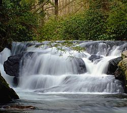
Wild Creek Falls in Beltzville State Park
Towamensing Logo.png
Map of Towamensing Township, Carbon County, Pennsylvania Highlighted.png
Location of Towamensing Township in Carbon County, Pennsylvania
Map of Pennsylvania highlighting Carbon County.svg
Location of Carbon County in Pennsylvania
Coordinates: 40°52′29″N75°37′30″W / 40.87472°N 75.62500°W / 40.87472; -75.62500
Country United States
State Pennsylvania
County Carbon
Area
[1]
  Total28.91 sq mi (74.89 km2)
  Land27.14 sq mi (70.28 km2)
  Water1.78 sq mi (4.61 km2)
Elevation
715 ft (218 m)
Population
 (2010)
  Total4,477
  Estimate 
(2016) [2]
4,409
  Density162.47/sq mi (62.73/km2)
Time zone UTC-5 (EST)
  Summer (DST) UTC-4 (EDT)
Area code(s) 610
FIPS code 42-025-77160
Website towamensingtownship.com

Towamensing Township is a lightly populated rural township in eastern Carbon County, Pennsylvania. It is part of Northeastern Pennsylvania.

Contents

The Lenape Indian tribe's name is eponymous and was once applied by the natives to the whole region [3] of Carbon County and bits of the Poconos to the north (Luzerne County) and to Schuylkill County (southwest). The population was 4,477 at the 2010 census, [4] up from 3,475 at the 2000 census. A portion of Beltzville State Park is in the township.

Geography

Towamensing Township is in southeastern Carbon County and is bordered by Monroe County to the east. According to the U.S. Census Bureau, the township has a total area of 28.9 square miles (74.9 km2), 27.1 square miles (70.3 km2) of which is land and 1.8 square miles (4.6 km2), or 6.15%, of which is water. [4] It is drained by Aquashicola Creek and Pohopoco Creek into the Lehigh River. The township's northern boundary runs along the base of Call Mountain. Its villages include Forest Inn, Jonesville, Stemlersville, and Trachsville.

Neighboring municipalities

Climate

The township has a humid continental climate (Dfa/Dfb) and the hardiness zone is 6a. Average monthly temperatures in Forest Inn range from in 27.0 °F in January to 71.2 °F in July. [5]

Demographics

Historical population
CensusPop.Note
2000 3,475
2010 4,47728.8%
2016 (est.)4,409 [2] −1.5%
U.S. Decennial Census [6]

As of the 2000 census, [7] there were 3,475 people, 1,275 households, and 1,003 families residing in the township. The population density was 128.6 people per square mile (49.7 people/km2). There were 1,458 housing units at an average density of 54.0 per square mile (20.8/km2). The racial makeup of the township was 98.65% White, 0.43% African American, 0.09% Native American, 0.23% Asian, 0.17% from other races, and 0.43% from two or more races. Hispanic or Latino of any race were 1.24% of the population.

There were 1,275 households, out of which 34.4% had children under the age of 18 living with them, 69.3% were married couples living together, 5.2% had a female householder with no husband present, and 21.3% were non-families. 15.8% of all households were made up of individuals, and 6.2% had someone living alone who was 65 years of age or older. The average household size was 2.71 and the average family size was 3.03.

In the township, the population was spread out, with 24.1% under the age of 18, 5.6% from 18 to 24, 30.9% from 25 to 44, 26.1% from 45 to 64, and 13.3% who were 65 years of age or older. The median age was 40 years. For every 100 females, there were 100.4 males. For every 100 females age 18 and over, there were 100.1 males.

The median income for a household in the township was $49,524, and the median income for a family was $51,135. Males had a median income of $36,638 versus $21,103 for females. The per capita income for the township was $19,629. About 4.5% of families and 4.7% of the population were below the poverty line, including 5.6% of those under age 18 and 6.7% of those age 65 or over.

Transportation

US Route 209 southbound in Towamensing Township 2022-08-08 09 49 55 View south along U.S. Route 209 (Interchange Road) just south of Preachers Camp Drive in Towamensing Township, Carbon County, Pennsylvania.jpg
US Route 209 southbound in Towamensing Township

As of 2020, there were 84.98 miles (136.76 km) of public roads in Penn Forest Township, of which 17.17 miles (27.63 km) were maintained by the Pennsylvania Department of Transportation (PennDOT) and 67.81 miles (109.13 km) were maintained by the township. [8]

U.S. Route 209 is the only numbered highway passing through Towamensing Township. It crosses from northeast-to-southwest on the southeast side of Beltzville Lake.

Related Research Articles

<span class="mw-page-title-main">Carbon County, Pennsylvania</span> County in Pennsylvania, United States

Carbon County is a county in the Commonwealth of Pennsylvania. It is located in Northeastern Pennsylvania. As of the 2020 census, the population was 64,749. The county is also part of Pennsylvania's Coal Region.

<span class="mw-page-title-main">Monroe Township, Bradford County, Pennsylvania</span> Township in Pennsylvania, United States

Monroe Township is a township in Bradford County, Pennsylvania, United States. It is part of Northeastern Pennsylvania. The population was 1,250 at the 2010 census.

<span class="mw-page-title-main">Beaver Meadows, Pennsylvania</span> Borough in Pennsylvania, United States

Beaver Meadows is a borough in Carbon County, Pennsylvania, United States. It is part of Northeastern Pennsylvania. The population was 897 at the 2020 U.S. census.

<span class="mw-page-title-main">Bowmanstown, Pennsylvania</span> Borough in Pennsylvania, United States

Bowmanstown is a borough in Carbon County, Pennsylvania. It is part of Northeastern Pennsylvania. The population was 937 at the 2010 census.

<span class="mw-page-title-main">East Penn Township, Pennsylvania</span> Place in Pennsylvania, United States

East Penn Township is a rural township in the rough uplands terrain of the eastern Mahoning Hills area of Carbon County, Pennsylvania. It is part of Northeastern Pennsylvania.

<span class="mw-page-title-main">Franklin Township, Carbon County, Pennsylvania</span> Place in Pennsylvania, United States

Franklin Township is a township in Carbon County, Pennsylvania. It is part of Northeastern Pennsylvania. The population was 4,262 at the 2010 census. A portion of Beltzville State Park is in Franklin Township.

<span class="mw-page-title-main">Kidder Township, Pennsylvania</span> Place in Pennsylvania, United States

Kidder Township is a township in Carbon County, Pennsylvania. It is part of Northeastern Pennsylvania. The population was 1,935 at the 2010 census, up from 1,185 at the 2000 census.

<span class="mw-page-title-main">Lausanne Township, Pennsylvania</span> Place in Pennsylvania, United States

Lausanne Township is a township in Carbon County, Pennsylvania. It is part of Northeastern Pennsylvania. The township dates back to 1808 when the first Lausanne settlement was organized with a local frontier government.

<span class="mw-page-title-main">Lower Towamensing Township, Pennsylvania</span> Place in Pennsylvania, United States

Lower Towamensing Township is a township in Carbon County, Pennsylvania. It is part of Northeastern Pennsylvania. The Lenape Indian tribe name is eponymous and was once applied by the natives to the whole region of Carbon County and bits of the Poconos to the north and to Schuylkill County (southwest). The population was 3,228 at the 2010 census.

<span class="mw-page-title-main">Mahoning Township, Carbon County, Pennsylvania</span> Place in Pennsylvania, United States

Mahoning Township is a township in Carbon County, Pennsylvania. It is part of Northeastern Pennsylvania. The population was 4,305 at the 2010 census, up from 3,978 at the 2000 census.

<span class="mw-page-title-main">Penn Forest Township, Pennsylvania</span> Place in Pennsylvania, United States

Penn Forest Township is a township in Carbon County, Pennsylvania. It is part of Northeastern Pennsylvania. The population was 9,581 at the 2010 census, up from 5,439 at the 2000 census.

<span class="mw-page-title-main">Washington Township, Lehigh County, Pennsylvania</span> Township in Pennsylvania, United States

Washington Township is a township in Lehigh County, Pennsylvania. The population of Washington Township was 6,624 at the 2010 census. It is a suburb of Allentown in the Lehigh Valley, which had a population of 861,899 and was the 68th-most populous metropolitan area in the U.S. as of the 2020 census.

<span class="mw-page-title-main">Eldred Township, Monroe County, Pennsylvania</span> Township in Pennsylvania, United States

Eldred Township is a township in Monroe County, Pennsylvania, United States. The population was 2,594 at the 2020 census.

<span class="mw-page-title-main">Polk Township, Monroe County, Pennsylvania</span> Place in Pennsylvania, United States

Polk Township is a township in Monroe County, Pennsylvania, United States. The population was 7,473 at the 2020 census.

<span class="mw-page-title-main">Smithfield Township, Monroe County, Pennsylvania</span> Place in Pennsylvania, United States

Smithfield Township is a township in Monroe County, Pennsylvania, United States. The population was 8,001 at the 2020 census.

<span class="mw-page-title-main">Lehigh Township, Northampton County, Pennsylvania</span> Place in Pennsylvania, United States

Lehigh Township is a township in Northampton County, Pennsylvania. The population of Lehigh Township was 10,526 as of the 2010 census. It is part of the Lehigh Valley metropolitan area, which had a population of 861,899 and was the 68th-most populous metropolitan area in the U.S. as of the 2020 census.

<span class="mw-page-title-main">Moore Township, Pennsylvania</span> Place in Pennsylvania, United States

Moore Township is a township in Northampton County, Pennsylvania. The population of Moore Township was 9,198 at the 2010 census. The township is located in the Lehigh Valley, which had a population of 861,899 and was the 68th-most populous metropolitan area in the U.S. as of the 2020 census.

<span class="mw-page-title-main">Plainfield Township, Pennsylvania</span> Place in Pennsylvania, United States

Plainfield Township is a township in Northampton County, Pennsylvania. The population of Plainfield Township was 6,138 at the 2010 census. The township is part of the Lehigh Valley metropolitan area, which had a population of 861,899 and was the 68th-most populous metropolitan area in the U.S. as of the 2020 census.

<span class="mw-page-title-main">West Penn Township, Pennsylvania</span> Township in Pennsylvania, United States

West Penn Township is a township in Schuylkill County, Pennsylvania, United States. The population was 4,383 in the 2020 census.

<span class="mw-page-title-main">Lake Harmony, Pennsylvania</span> Unincorporated community in Pennsylvania, United States

Lake Harmony is an unincorporated community in Kidder Township, Carbon County, Pennsylvania, United States. The population was 718 at the 2010 census. It is served by ZIP Code 18624.

References

  1. "2016 U.S. Gazetteer Files". United States Census Bureau. Retrieved August 13, 2017.
  2. 1 2 "Population and Housing Unit Estimates" . Retrieved June 9, 2017.
  3. Fred Brenckman (1913). "Chapter V. Captivity of the Gilbert Family". History of Carbon County Pennsylvania. Harrisburg, PA: Publisher: James J. Nungesser ('gutenberg project' e-reprint). p. 62. ... before the ring of the axe was again heard in the forests, and the curling smoke wreaths ascended from the chimneys of the log cabins of Towamensing, as this whole region was then known.
  4. 1 2 "Geographic Identifiers: 2010 Census Summary File 1 (G001): Towamensing township, Carbon County, Pennsylvania". U.S. Census Bureau, American Factfinder. Archived from the original on April 7, 2015. Retrieved April 7, 2015.
  5. http://prism.oregonstate.edu/explorer/
  6. "Census of Population and Housing". Census.gov. Retrieved June 4, 2016.
  7. "U.S. Census website". United States Census Bureau . Retrieved January 31, 2008.
  8. "Towamensing Township map" (PDF). PennDOT. Retrieved March 17, 2023.