New Orleans tornado of 2017

Last updated
New Orleans tornado of 2017
EF3 tornado
2017 New Orleans tornado over Michoud area.png
The tornado in the Michoud area of New Orleans East
Formed 11:12 a.m. CST (17:12 UTC) February 7, 2017 [1]
Duration 20 minutes
Dissipated 11:32 a.m. CST (17:32 UTC) February 7, 2017 [1]
Max rating1 EF3 tornado
Highest winds
  • 150 mph (240 km/h) [2]
Damage >$2.7 million
Total fatalities None; 33 injuries, 6 serious [1]
Areas affected Orleans Parish, Louisiana

1Most severe tornado damage; see Fujita scale

Part of the tornadoes of 2017

The New Orleans tornado of 2017 was a large and powerful EF3 tornado that was the strongest to strike New Orleans, Louisiana in recorded history. [3] The tornado, which touched down on Tuesday, February 7, 2017, caused considerable damage along its path and left approximately 10,000 homes without electricity. [4] This was one of several strong tornadoes that touched down across Louisiana and Mississippi that day. [5]

Tornado Violently rotating column of air that is in contact with both the earths surface and a cumulonimbus cloud in the air

A tornado is a rapidly rotating column of air that is in contact with both the surface of the Earth and a cumulonimbus cloud or, in rare cases, the base of a cumulus cloud. The windstorm is often referred to as a twister, whirlwind or cyclone, although the word cyclone is used in meteorology to name a weather system with a low-pressure area in the center around which, from an observer looking down toward the surface of the earth, winds blow counterclockwise in the Northern Hemisphere and clockwise in the Southern. Tornadoes come in many shapes and sizes, and they are often visible in the form of a condensation funnel originating from the base of a cumulonimbus cloud, with a cloud of rotating debris and dust beneath it. Most tornadoes have wind speeds less than 110 miles per hour (180 km/h), are about 250 feet (80 m) across, and travel a few miles before dissipating. The most extreme tornadoes can attain wind speeds of more than 300 miles per hour (480 km/h), are more than two miles (3 km) in diameter, and stay on the ground for dozens of miles.

Electricity Physical phenomena associated with the presence and flow of electric charge

Electricity is the set of physical phenomena associated with the presence and motion of matter that has a property of electric charge. In early days, electricity was considered as being not related to magnetism. Later on, many experimental results and the development of Maxwell's equations indicated that both electricity and magnetism are from a single phenomenon: electromagnetism. Various common phenomena are related to electricity, including lightning, static electricity, electric heating, electric discharges and many others.

Contents

In response to the disaster, Governor John Bel Edwards declared a state of emergency. [6] 33 injuries occurred in the area after the tornado hit near Chef Menteur Highway with hundreds of structures sustaining moderate to significant damage along the ten-mile path.

John Bel Edwards 56th Governor of Louisiana

John Bel Edwards is an American politician and lawyer serving as the 56th Governor of Louisiana since 2016. He was previously the Minority Leader of the Louisiana House of Representatives for two terms. He left the state legislature to run for governor in 2015. A member of the Democratic Party, he defeated Republican U.S. Senator David Vitter in the second round of the 2015 election. He is a United States Army veteran, having served with the 82nd Airborne Division.

State of emergency Legal declaration or de facto acts by a government allowing assumption of extraordinary powers

A state of emergency is a situation in which a government is empowered to perform actions that it would normally not be permitted to do. A government can declare such a state during a disaster, civil unrest, or armed conflict. Such declarations alert citizens to change their normal behavior and orders government agencies to implement emergency plans. Justitium is its equivalent in Roman law—a concept in which the senate could put forward a final decree that was not subject to dispute.

U.S. Route 90 in Louisiana highway in Louisiana

U.S. Highway 90 in Louisiana , one of the major east–west U.S. Highways in the Southern United States, runs through southern Louisiana for 297.6 miles (478.9 km), serving Lake Charles, Lafayette, New Iberia, Morgan City, and New Orleans. Much of it west of Lafayette and east of New Orleans has been supplanted by Interstate 10 (I-10) for all but local traffic, but the section between Lafayette and New Orleans runs a good deal south of I-10.

Meteorological synopsis

On February 4, the Storm Prediction Center (SPC) outlined a severe weather threat area across portions of the Ohio Valley southward into the northern Gulf Coast states. [7] A corresponding Slight risk of severe weather was issued the following day from central Indiana and Ohio to northern Mississippi and Alabama, encompassed within a larger Marginal risk. [8] Little change occurred for the 07:00 UTC Day 2 outlook, [9] but the Marginal risk was eventually shifted to encompass portions of eastern Louisiana on the 17:30 UTC forecast. [10] Early on February 7, the SPC expanded the Slight risk area and subsequently introduced a small Enhanced risk for portions of eastern Louisiana, southern Mississippi, southwestern Alabama, and the extreme western Florida Panhandle, although its intent was for the potential for large hail instead of significant tornadoes. [11] [12]

Storm Prediction Center sub-agency of the United States National Weather Service

The Storm Prediction Center (SPC) is a government agency that is part of the National Centers for Environmental Prediction (NCEP), operating under the control of the National Weather Service (NWS), which in turn is part of the National Oceanic and Atmospheric Administration (NOAA) of the United States Department of Commerce (DoC).

Ohio River river in the midwestern United States

The Ohio River is a 981-mile (1,579 km) long river in the midwestern United States that flows southwesterly from western Pennsylvania south of Lake Erie to its mouth on the Mississippi River at the southern tip of Illinois. It is the second largest river by discharge volume in the United States and the largest tributary by volume of the north-south flowing Mississippi River that divides the eastern from western United States. The river flows through or along the border of six states, and its drainage basin includes parts of 15 states. Through its largest tributary, the Tennessee River, the basin includes several states of the southeastern U.S. It is the source of drinking water for three million people.

Gulf Coast of the United States Coastline in the United States

The Gulf Coast of the United States is the coastline along the Southern United States where they meet the Gulf of Mexico. The coastal states that have a shoreline on the Gulf of Mexico are Texas, Louisiana, Mississippi, Alabama, and Florida, and these are known as the Gulf States.

On February 7, an intensifying southern-stream shortwave trough progressed eastward from the southern Great Plains to the lower Mississippi Valley. [11] Ahead of the trough, strong low- to mid-level winds transported abundant moisture northward from the Gulf of Mexico, with dewpoints reaching to lower to mid 60s °F. [12] The combination of southwesterly flow and abnormally cold mid-level temperatures—approximately −14 °C (7 °F) to −17 °C (1 °F)—helped to destabilize the atmosphere, with maximum Convective Available Potential Energy values in the range of 1500–2000 j/kg. Veering winds—winds that turn clockwise with height—acted to lengthen hodographs and provide significant directional wind shear, with 0–6 km shear of 35–45 mph (55–75 km/h) and 0–3 km storm relative helicities of 200–300 m2/s2. [11] [13] Meanwhile, incredibly steep mid-level lapse rates near or above 8 C/km overspread the risk area. [12] The increasingly conducive environment prompted the SPC to issue a tornado watch across southern Louisiana and Mississippi, valid from 7:55 a.m. CST (13:55 UTC) to 2:00 p.m. CST (21:00 UTC); forecasters assessed a 50% chance of two or more tornadoes in the watch box, but only a 20% chance of one or more strong (EF2+) tornadoes. [14]

Jet stream Fast-flowing atmospheric air-current

Jet streams are fast flowing, narrow, meandering air currents in the atmospheres of some planets, including Earth. On Earth, the main jet streams are located near the altitude of the tropopause and are westerly winds. Their paths typically have a meandering shape. Jet streams may start, stop, split into two or more parts, combine into one stream, or flow in various directions including opposite to the direction of the remainder of the jet.

Shortwave (meteorology) meteorology

A shortwave or shortwave trough is an embedded kink in the trough / ridge pattern. Its length scale is much smaller than that of longwaves, which are responsible for the largest scale weather systems. Shortwaves may be contained within or found ahead of longwaves and range from the mesoscale to the synoptic scale. Shortwaves are most frequently caused by either a cold pool or an upper level front.

Great Plains broad expanse of flat land west of the Mississippi River and east of the Rocky Mountains in the United States and Canada

The Great Plains is the broad expanse of flat land, much of it covered in prairie, steppe, and grassland, that lies west of the Mississippi River tallgrass prairie in the United States and east of the Rocky Mountains in the U.S. and Canada. It embraces:

Damage path

EF3 damage to a church in East New Orleans. EF3ChurchDamageNewOrleans2017.JPG
EF3 damage to a church in East New Orleans.

The tornado initially touched down along Old Gentilly Road to the east of the New Orleans Industrial Canal. EF0 damage was noted at the beginning of the path as homes sustained minor roof damage. EF1 damage occurred near Wilson Avenue as a two-story motel had much of its poorly attached roof uplifted and sustained buckling of exterior walls on the second floor. The tornado moved northeastward, attaining high-end EF2 intensity by the time it reached the Chef Menteur Highway. Metal power poles were bent, wooden power poles were snapped, a business was severely damaged, and an apartment complex sustained significant roof damage and collapse of a brick fascia exterior wall in this area. Damage surveys indicate that as the tornado continued on this northeastward track, it became multiple-vortex in structure, with a second circulation north of the first taking over as the predominant one. This second vortex, as the tornado did when it originally touched down, moved in a northeastward direction and produced EF2 damage near the Flake Street/Grant Avenue intersection. A small, poorly constructed home along Flake Street was rolled off of its cinder block foundation and completely destroyed, while nearby homes sustained shingle and porch damage. East of Crowder Boulevard, a continuous swath of mainly EF2 damage was noted as the now large and destructive tornado moved through residential areas, severely damaging numerous homes, many of which had their roofs ripped off. A few of these homes sustained some failure of exterior walls. Vehicles in this area were flipped and damaged, some of which were tossed into homes. On Arthur Drive and Charlene Drive, a small pocket of EF3 damage was noted as two homes lost most of their exterior walls, and had one or two of their interior walls collapse due to winds estimated by the NWS to have been around 140 miles per hour (230 km/h). [15]

Industrial Canal canal in Louisiana, United States of America

The Industrial Canal is a 5.5 mile (9 km) waterway in New Orleans, Louisiana, United States. The waterway's proper name, as used by the U.S. Army Corps of Engineers and on NOAA nautical charts, is Inner Harbor Navigation Canal (IHNC). The more common "Industrial Canal" name is used locally, both by commercial mariners and by landside residents.

Damage to vehicles at the National Finance Center. National Finance Center tornado damage 2017-02-08.jpg
Damage to vehicles at the National Finance Center.

Along Grant Street, Schaumburg Elementary School sustained minor roof damage and broken windows as it was impacted by the outer edge of the circulation. Children inside the school took shelter in an interior hallway as the tornado struck and were not injured. Just east of this point, a large area of mid-range EF3 damage was observed. This damage was confined to an area along and just north of Grant Street between Read Boulevard and Chalmark Drive, where dozens of homes lost much to all of their roof structures and sustained collapse of multiple exterior walls. Large, two-story brick homes had only one or two interior corner walls left standing on their top floors, and a two-story apartment building sustained total roof loss and collapse of numerous second floor walls, with some collapse of first floor exterior walls noted as well. It was determined that the tornado reached peak its intensity in this area, with winds estimated at 150 miles per hour (240 km/h). The tornado then caused high-end EF2 damage further to the east as it moved through additional residential areas. Many homes in this area had roofs torn off and sustained some collapse of exterior walls. A second small area of mid-range EF3 damage was noted near Hauck Drive, where a large church was left with only one exterior wall standing, and sustained total collapse of most interior walls. Winds at this location were again estimated around 150 miles per hour (240 km/h). [2]

The tornado essentially followed the Chef Menteur Highway as it continued eastward, significantly damaging homes and other structures at EF2 strength along this segment of the path. A small strip mall and a church sustained major roof damage and had every window blown out, a gas station was heavily damaged and had its service station canopy shredded. Homes had their roofs completely removed, and many concrete light poles were snapped. A final segment of low-end EF3 damage occurred further east as several large metal power pylons along the highway were bent in half. High-end EF2 damage occurred in neighborhoods just north of the highway, as numerous homes sustained significant roof and exterior wall loss. Past Bullard Avenue, the tornado weakened to EF1 strength and the damage path shifted southward. Numerous small trees were snapped near the Interstate 510 and Almonaster Avenue interchange. The tornado then restrengthened to EF2 intensity as it caused heavy damage to NASA's Michoud Assembly Facility. Windows were blown out, and large metal industrial buildings sustained major structural damage. The large, two-story office building that houses the National Finance Center suffered significant roof damage and collapse of both the brick facade and cinder block exterior walls in a few places. Vehicles in the National Finance Center parking lot were severely damaged. The tornado then continued eastward across unpopulated marshy areas before dissipating over Lake Borgne. [2]

In all, the tornado significantly damaged or destroyed at least 638 homes and 40 businesses along its 10.1-mile-long (16.3 km) path, and hundreds of trees and power poles were snapped. Thirty-three people were injured, six severely; however, no fatalities took place. [2] Two public schools— Schaumburg Elementary and Einstein Charter School—both sustained some damage to buildings and property, with collective damage reaching $1.7 million. [16] NASA's Michoud Assembly Facility suffered more than $1 million in damage. [17]

Other tornadoes

The New Orleans tornado was part of a small outbreak of tornadoes that impacted the Southern United States on February 7, a few of which were strong. This included an EF3 near Watson, Louisiana that toppled a metal truss tower, badly damaged a metal building, and destroyed manufactured homes. An EF1 struck the town of Donaldsonville, causing considerable damage to structures and killing one person. A large EF2 wedge tornado that passed near Killian and Akers downed many trees and destroyed small house built on a cinder block foundation. Another EF2 destroyed a flea market near Harperville, Mississippi as well. A total of 15 tornadoes were confirmed across parts of Louisiana, Mississippi, Alabama, Florida, Georgia, Tennessee, and Kentucky.

Related Research Articles

Tornadoes of 2008

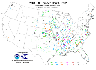
This page documents notable tornadoes and tornado outbreaks worldwide in 2008. Strong and destructive tornadoes form most frequently in the United States, Bangladesh, and Eastern India, but they can occur almost anywhere under the right conditions. Tornadoes also develop occasionally in southern Canada during the Northern Hemisphere's summer and somewhat regularly at other times of the year across Europe, Asia, and Australia. Tornadic events are often accompanied with other forms of severe weather, including strong thunderstorms, strong winds, and hail.

Tornadoes of 2009

In 2009, tornadic activity was generally near average. Each year, tornadoes and tornado outbreaks occur worldwide primarily under conductive conditions, though a majority of tornadoes form in the United States. Tornadoes also occur to a less frequent extent in Europe, Asia, and Australia. In the U.S., there were 1,304 reports of tornadoes received by the Storm Prediction Center (SPC), and 1,159 tornadoes were confirmed to have taken place. Worldwide, 45 fatalities were caused by tornadoes, with 22 in the U.S., 15 in India, four in Canada, two in Greece and one each in Serbia and Russia.

2010 New Years Eve tornado outbreak

The 2010 New Year's Eve tornado outbreak was a three-day-long tornado outbreak that impacted the central and lower Mississippi Valley from December 30, 2010 to January 1, 2011. Associated with a low pressure system and a strong cold front, 37 tornadoes tracked across five states over the length of the severe event, killing nine and injuring several others. Activity was centered in the states of Missouri and later Mississippi on December 31. Seven tornadoes were rated EF3 on the Enhanced Fujita Scale; these were the strongest during the outbreak. Non-tornadic winds were recorded to have reached as high as 80 mph (130 km/h) at eight locations on December 31, while hail as large as 2.75 in (7.0 cm) was documented north-northeast of Mansfield, Missouri. Overall, damage from the outbreak totaled US$123.3 million, most of which was related to tornadoes.

Tornadoes of 2012

This page documents the tornadoes and tornado outbreaks of 2012. Extremely destructive tornadoes form most frequently in the U.S., Bangladesh, Brazil and Eastern India, but they can occur almost anywhere under the right conditions. Tornadoes also appear regularly in neighboring southern Canada during the Northern Hemisphere's summer season, and somewhat regularly in Europe, Asia, Argentina, and Australia.

Tornado outbreak of March 2–3, 2012 tornado outbreak

On March 2 and 3, 2012, a deadly tornado outbreak occurred over a large section of the Southern United States into the Ohio Valley region. The storms resulted in 41 tornado-related fatalities, 22 of which occurred in Kentucky. Tornado-related deaths also occurred in Alabama, Indiana, and Ohio. The outbreak was the second deadliest in early March for the U.S. since official records began in 1950; only the 1966 Candlestick Park tornado had a higher death toll for a tornadic system in early March.

2011 Tuscaloosa–Birmingham tornado

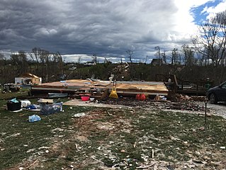
The 2011 Tuscaloosa–Birmingham tornado was a large and violent EF4 multiple-vortex tornado that devastated portions of Tuscaloosa and Birmingham, Alabama, as well as smaller communities and rural areas between the two cities, during the late afternoon and early evening of Wednesday, April 27, 2011. It is one of the costliest tornadoes on record. It was one of the 360 tornadoes in the 2011 Super Outbreak, the largest tornado outbreak in United States history. The tornado reached a maximum path width of 1.5 miles (2.4 km) during its track through Tuscaloosa, and once again when it crossed Interstate 65 north of Birmingham, and attained estimated winds of 190 mph (310 km/h) shortly after passing through the city. It then went on to impact parts of Birmingham as a high-end EF4 before dissipating. This was the third tornado to strike the city of Tuscaloosa in the past decade, and the second in two weeks.

Tornadoes of 2013 Wikimedia list article

This page documents the tornadoes and tornado outbreaks of 2013. Strong and destructive tornadoes form most frequently in the United States, Bangladesh, Brazil and Eastern India, but they can occur almost anywhere under the right conditions. Tornadoes also appear regularly in neighboring southern Canada during the Northern Hemisphere's summer season, and somewhat regularly in Europe, Asia, and Australia.

Late December 2012 North American storm complex

Near the end of 2012, a massive storm complex developed that produced both a tornado outbreak and a blizzard across the southern and eastern United States. On Christmas Day 2012, a tornado outbreak occurred across Southern United States. This severe weather/tornado event affected the United States Gulf Coast and southern East Coast over a two-day span. It occurred in conjunction with a much larger winter storm event that brought blizzard conditions to much of the interior United States. In total, 31 tornadoes were confirmed by the National Weather Service in five states from Texas to North Carolina. All but one of the tornadoes that occurred during the outbreak touched down on December 25, with the other occurring the following day in North Carolina. Two of the tornadoes were destructive enough to be rated EF3 on the Enhanced Fujita Scale. At least 16 people died as a result of the related blizzard, and thousands were without power.

2013 Hattiesburg, Mississippi tornado

The 2013 Hattiesburg, Mississippi tornado was a large and violent EF4 multiple-vortex wedge tornado that, on Sunday, February 10, 2013, devastated the city of Hattiesburg, Mississippi as well as portions of surrounding areas of West Hattiesburg, Hattiesburg, and Petal. The tornado was one of eight that touched down in southern Mississippi and southwestern Alabama that day. It reached a maximum path width of 0.75 mi (1.21 km) in its path through the Hattiesburg area and reached estimated maximum sustained winds of 170 mph (270 km/h) in Oak Grove neighborhood of West Hattiesburg. It destroyed many structures and impacted University of Southern Mississippi and two high schools. Mississippi was declared a federal disaster area by President Barack Obama, and a state of emergency was issued by Mississippi Governor Phil Bryant.

Tornado outbreak of November 17, 2013

The tornado outbreak of November 17, 2013, was the deadliest and costliest in the U.S. state of Illinois to occur in the month of November and fourth largest for the state overall. Associated with a strong trough in the upper levels of the atmosphere, the event resulted in 73 tornadoes tracking across regions of the Midwest United States and Ohio River Valley, impacting seven states. Severe weather during the tornado outbreak caused over 100 injuries and eleven fatalities, of which eight were tornado related. Two tornadoes—both in Illinois and rated EF4 on the Enhanced Fujita Scale—were the strongest documented during the outbreak and combined for five deaths. In addition to tornadoes, the system associated with the outbreak produced sizeable hail peaking at 4.00 in (10.2 cm) in diameter in Bloomington, Illinois, as well as damaging winds estimated as strong as 100 mph (160 km/h) in three locations.

Tornadoes of 2015

This page documents notable tornadoes and tornado outbreaks worldwide in 2015. Strong and destructive tornadoes form most frequently in the United States, Bangladesh, Brazil and Eastern India, but they can occur almost anywhere under the right conditions. Tornadoes also develop occasionally in southern Canada during the Northern Hemisphere's summer and somewhat regularly at other times of the year across Europe, Asia, and Australia. Tornadic events are often accompanied with other forms of severe weather including strong thunderstorms, winds and hail.

Tornadoes of 2016

This page documents notable tornadoes and tornado outbreaks worldwide in 2016. Strong and destructive tornadoes form most frequently in the United States, Bangladesh, Brazil and Eastern India, but they can occur almost anywhere under the right conditions. Tornadoes also develop occasionally in southern Canada during the Northern Hemisphere's summer and somewhat regularly at other times of the year across Europe, Asia, and Australia. Tornadic events are often accompanied with other forms of severe weather, including strong thunderstorms, strong winds, and hail.

Tornadoes of 2017

This page documents notable tornadoes and tornado outbreaks worldwide in 2017. Strong and destructive tornadoes form most frequently in the United States, Brazil, Bangladesh, and Eastern India, but they can occur almost anywhere under the right conditions. Tornadoes also develop occasionally in southern Canada during the Northern Hemisphere's summer and somewhat regularly at other times of the year across Europe, Asia,Argentina and Australia. Tornadic events are often accompanied with other forms of severe weather, including strong thunderstorms, strong winds, and hail.

Tornado outbreak of January 21–23, 2017 prolific winter tornado outbreak in the Southeastern United States

The tornado outbreak of January 21–23, 2017 was a prolific and deadly winter tornado outbreak that occurred across the Southeast United States. Lasting just under two days, the outbreak produced a total of 81 tornadoes, cementing its status as the second-largest January tornado outbreak and the third-largest winter tornado outbreak since 1950. Furthermore, it was the largest outbreak on record in Georgia with 42 tornadoes confirmed in the state. The most significant tornadoes were three EF3s that heavily damaged or destroyed portions of Hattiesburg, Mississippi, and Albany and Adel, Georgia. A total of 20 people were killed by tornadoes—mainly during the pre-dawn hours of the outbreak—making it the second-deadliest outbreak in January since 1950, behind the 1969 Hazlehurst, Mississippi tornado outbreak that killed 32 people. In the aftermath of the outbreak, relief organizations assisted in clean-up and aid distribution. Total economic losses from the event reached at least $1.3 billion.

2015 Rochelle–Fairdale, Illinois tornado

The 2015 Rochelle–Fairdale, Illinois tornado was an extremely violent and long-lived tornado that tore through the communities near Rochelle and in Fairdale, Illinois throughout the evening hours of April 9, 2015. Part of a larger severe weather event that impacted the Central United States, the tornado first touched down in Lee County at 6:39 p.m. CDT (22:39 UTC). It progressed through the counties of Ogle, DeKalb, and Boone before finally dissipating at 7:20 p.m. CDT. Along the tornado's 30.14 mi (48.51 km) path, numerous structures were heavily damaged or destroyed, especially in the small town of Fairdale where two fatalities and eleven injuries were recorded. A few well-constructed homes were swept completely away, indicative of peak winds near 200 mph (320 km/h), the upper bounds of an EF4 tornado. In the aftermath of the event, hundreds of citizens assisted in cleanup and recovery efforts. Economic losses from the tornado reached $19 million.

Tornado outbreak of February 28 – March 1, 2017

The tornado outbreak of February 28 – March 1, 2017 was a widespread and significant outbreak of tornadoes and severe weather that affected the Midwestern United States at the end of February 2017 and beginning of March. Fueled by the combination of ample instability, strong wind shear, and rich low-level moisture, the event led to 72 confirmed tornadoes and thousands of other non-tornadic severe weather reports. The most notable aspect of the outbreak was a long-tracked EF4 tornado—the first violent tornado of 2017 and the first violent tornado during the month of February since the 2013 Hattiesburg, Mississippi tornado—that tracked from Perryville, Missouri to near Christopher, Illinois, killing one person. Three EF3 tornadoes were recorded during the event, including one that caused two fatalities in Ottawa, Illinois, one that caused a fatality near Crossville, and one that heavily damaged or destroyed homes in and around Washburn. In addition to the deaths, 38 people were injured by tornadoes and an additional 30 were injured by non-tornadic impacts, mainly by fallen trees.

Tornado outbreak of April 13–15, 2018

The tornado outbreak of April 13–15, 2018 was a multi-day and significant tornado outbreak that affected portions of the Midwest across to the East Coast of the United States. This particular outbreak led to at least 73 confirmed tornadoes over a three-day period, most of which occurred across Arkansas and Louisiana during the evening hours of April 13. The most significant tornadoes were an EF1 that caused a fatality in Red Chute, Louisiana, early on April 14, an upper-end EF2 tornado that impacted eastern sections of Greensboro, North Carolina on April 15, causing 17 injuries, and a significant EF3 tornado that impacted areas from Lynchburg to Elon, Virginia, causing severe damage and at least 10 injuries. The larger extratropical cyclone responsible for the outbreak also resulted in a record-breaking and severe winter storm across the Midwest into the Northeastern United States; killing three additional people and leaving hundreds of thousands without power.

Tornadoes of 2019 A list of 2019 tornadoes.

This page documents notable tornadoes and tornado outbreaks worldwide in 2019. Strong and destructive tornadoes form most frequently in the United States, Argentina, Brazil, Bangladesh, and Eastern India, but can occur almost anywhere under the right conditions. Tornadoes also develop occasionally in southern Canada during the Northern Hemisphere's summer and somewhat regularly at other times of the year across Europe, Asia, Argentina, and Australia. Tornadic events are often accompanied by other forms of severe weather, including strong thunderstorms, strong winds, and hail.

Tornado outbreak of March 3, 2019 Severe weather effect in the Southeastern United States

The tornado outbreak of March 3, 2019 was a significant severe weather event that affected the Southeastern United States. Over the course of 6 hours, a total of 41 tornadoes touched down across portions of Alabama, Georgia, Florida, and South Carolina. The strongest of these was an EF4 tornado that devastated rural communities from Beauregard, Alabama to Talbotton, Georgia, killing 23 people and injuring at least 100 others. Its death toll represented more than twice the number of tornado deaths in the United States in 2018, and it was the deadliest single tornado in the country since the 2013 Moore EF5 tornado. An EF3 tornado destroyed residences to the east of Tallahassee in Leon County, Florida, and was only the second tornado of that strength in the county since 1945. Several other strong tornadoes occurred across the region throughout the evening of March 3 and caused significant damage. A large number of EF0 and EF1 tornadoes also touched down.

Tornado outbreak of April 13–15, 2019 Severe weather effect in the Southeastern United States

The tornado outbreak of April 13–15, 2019, was a significant severe weather event that affected the multiple regions of the Eastern United States. Over the course of 40 hours, 70 tornadoes touched down. The outbreak produced numerous strong tornadoes throughout portions of the Deep South, while additional significant tornadoes occurred as far north as Ohio, Pennsylvania, and Delaware. The most significant tornado of the event was a long-tracked, high-end EF3 tornado that struck Alto, Texas and killed two people. Numerous weak tornadoes were also confirmed, along with numerous reports of hail and damaging straight line winds. Damage surveys are still ongoing.

References

  1. 1 2 3 Multiple Tornadoes Confirmed on 02/07/2017 (Report). Iowa Environmental Mesonet. National Weather Service Weather Forecast Office in New Orleans, Louisiana. February 9, 2017. Retrieved February 10, 2017.
  2. 1 2 3 4 "NWS Damage Assessment Toolkit". National Oceanic and Atmospheric Administration. Retrieved February 10, 2017.
  3. Norwood, Nicondra (2016-08-27). "New Orleans East tornado strongest on record for the city - FOX 8 WVUE New Orleans News, Weather, Sports, Social". Fox8live.com. Retrieved 2017-02-09.
  4. "Tornadoes rip through New Orleans area, decimating homes and neighborhoods". usatoday.com. Retrieved 8 February 2017.
  5. "NWS Damage Assessment Toolkit". 54.243.139.84. Retrieved 2017-02-14.
  6. "Tornadoes touch down, wreak havoc in Louisiana". cbsnews.com. Retrieved 8 February 2017.
  7. Steve Goss (February 4, 2017). "Day 4-8 Severe Weather Outlook Issued on Feb 4, 2017". Storm Prediction Center. Retrieved February 9, 2017.
  8. Steve Goss (February 5, 2017). "Feb 5, 2017 0830 UTC Day 3 Severe Thunderstorm Outlook". Storm Prediction Center. Retrieved February 9, 2017.
  9. Steve Goss (February 6, 2017). "Feb 6, 2017 0700 UTC Day 2 Convective Outlook". Storm Prediction Center. Retrieved February 9, 2017.
  10. Aaron Gleason (February 6, 2017). "Feb 6, 2017 1730 UTC Day 2 Convective Outlook". Storm Prediction Center. Retrieved February 9, 2017.
  11. 1 2 3 Chris Broyles; Matt Mosier (February 7, 2017). "Feb 7, 2017 0600 UTC Day 1 Convective Outlook". Storm Prediction Center. Retrieved February 9, 2017.
  12. 1 2 3 Jared Guyer (February 7, 2017). "Feb 7, 2017 1300 UTC Day 1 Convective Outlook". Storm Prediction Center. Retrieved February 9, 2017.
  13. Ryan Jewell; Jared Guyer (February 7, 2017). "Mesoscale Discussion 144". Storm Prediction Center. Retrieved February 9, 2017.
  14. Jared Guyer (February 7, 2017). "Tornado Watch 26". Storm Prediction Center. Retrieved February 10, 2017.
  15. Public Information Statement (Report). NWS New Orleans/Baton Rouge, LA. February 10, 2017. Archived from the original on February 10, 2017.
  16. Danielle Dreilinger (February 14, 2017). "Tornado damage to New Orleans schools estimated at $1.7 million". NOLA. Retrieved February 15, 2017.
  17. Paul Murphy (February 9, 2017). "NASA facility in NO East vows to reopen after tornado". WWV-TV. Retrieved February 10, 2017.

PD-icon.svg This article incorporates  public domain material from websites or documents ofthe National Weather Service .