Stratford is a town in east London, England, within the ceremonial county of Greater London. Until 1965 it was within the historic county of Essex. Part of the Lower Lea Valley, Stratford is situated 6 miles (9.7 km) east-northeast of Charing Cross, and includes the localities of Maryland and East Village.
West Ham is an area in East London, located 6.1 mi (9.8 km) east of Charing Cross in the west of the modern London Borough of Newham.

The London Borough of Barking and Dagenham is a London borough in East London. It lies around 9 miles (14.4 km) east of Central London. It is an Outer London borough and the south is within the London Riverside section of the Thames Gateway; an area designated as a national priority for urban regeneration. At the 2011 census it had a population of 187,000, the majority of which are within the Becontree estate. The borough's three main towns are Barking, Chadwell Heath and Dagenham. The local authority is the Barking and Dagenham London Borough Council. Barking and Dagenham was one of six London boroughs to host the 2012 Summer Olympics.
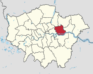
The London Borough of Newham is a London borough created in 1965 by the London Government Act 1963. It covers an area previously administered by the Essex county boroughs of West Ham and East Ham, authorities that were both abolished by the same act. The name Newham reflects its creation and combines the compass points of the old borough names. Situated in the East London part of Inner London, Newham has a population of 387,576, which is the third highest of the London boroughs and also makes it the 17th most populous district in England. The local authority is Newham London Borough Council.
Plaistow is a suburban area of East London, England, within the London Borough of Newham. It adjoins Upton Park to the north, East Ham to the east, Beckton to the south, Canning Town to the south-west and West Ham to the west.

East Ham is a district of the London Borough of Newham, England, 8 miles (12.8 km) east of Charing Cross. East Ham is identified in the London Plan as a Major Centre. The population is 76,186.
Canning Town is a district in the London Borough of Newham, East London. The district is located to the north of the Royal Victoria Dock, and has been described as the "Child of the Victoria Docks" as the timing and nature of its urbanisation was largely due to the creation of the dock. The area was part of the ancient parish of West Ham, in the hundred of Becontree, and part of the historic county of Essex. It forms part of the London E16 postcode district.
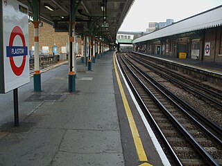
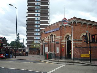
Plaistow is a London Underground station on Plaistow Road in the London Borough of Newham in Greater London. It is between West Ham and Upton Park stations on the District and Hammersmith & City lines, and in Travelcard Zone 3.

Beckton is a suburb in east London, England, located 8 miles (12.9 km) east of Charing Cross and part of the London Borough of Newham. Adjacent to the River Thames, the area consisted of unpopulated marshland known as the East Ham Levels in the parishes of Barking, East Ham, West Ham and Woolwich. The development of major industrial infrastructure in the 19th century to support the growing metropolis of London caused an increase in population with housing built in the area for workers of the Beckton Gas Works and Beckton Sewage Treatment Works. The area has a convoluted local government history and has formed part of Greater London since 1965. Between 1981 and 1995 it was within the London Docklands Development Corporation area, which caused the population to increase as new homes were built and the Docklands Light Railway was constructed.

East London is the northeastern part of London, United Kingdom. Located east of the ancient City of London and north of the River Thames as it begins to widen, East London developed as London's docklands and the primary industrial centre. The expansion of railways in the 19th century encouraged the eastward expansion of the East End of London and a proliferation of new suburbs. The industrial lands of East London are today an area of regeneration, which are well advanced in places such as Canary Wharf and ongoing elsewhere.
East Ham was a local government district in the far south west of Essex from 1878 to 1965. It extended from Wanstead Flats in the north to the River Thames in the south and from Green Street in the west to Barking Creek in the east. It was part of the London postal district and Metropolitan Police District.
West Ham was a local government district in the extreme south west of Essex from 1886 to 1965, forming part of the built-up area of London, although outside the County of London. It was immediately north of the River Thames and east of the River Lea.

Barking was a local government district, and later civil parish and borough, in southwest Essex, England from 1882 to 1965. It was known as Barking Town from 1882 to 1931. The district included the town of Barking, eastern Beckton and the southwestern part of the Becontree estate. The district was within the Metropolitan Police District and experienced a steady increase in population during its existence. It now forms the western part of the London Borough of Barking and Dagenham and the eastern extremity of the London Borough of Newham in Greater London.
Ilford was a civil parish and local government district in south west Essex, England from 1888 to 1965, covering the town Ilford. The district saw a considerable rise in population throughout its life, caused by the expansion of the built-up area of London, and became one of the most populous districts of its type in England. The district now corresponds to the greater part of the London Borough of Redbridge in Greater London.

Newham London Borough Council is the local authority for the London Borough of Newham. It is a London borough council, one of 32 in the United Kingdom capital of London. The council is unusual in that its executive function is controlled by a directly elected mayor of Newham, currently Rokhsana Fiaz. The council was created by the London Government Act 1963 and replaced four local authorities: East Ham Borough Council, West Ham Borough Council, Barking Borough Council and Woolwich Metropolitan Borough Council.

Camden Town Hall, known as St Pancras Town Hall until 1965, is the headquarters of Camden London Borough Council. The main entrance is in Judd street with its northern elevation extending along Euston Road, opposite the main front of St Pancras railway station. It has been Grade II listed since 1996.

Stratford Langthorne Abbey, or the Abbey of St Mary's, Stratford Langthorne was a Cistercian monastery founded in 1135 at Stratford Langthorne — then Essex but now Stratford in the London Borough of Newham. The Abbey, also known as West Ham Abbey as it lay in that parish, was one of the largest Cistercian abbeys in England, possessing 1,500 acres (6.07 km2) of local land, controlling over 20 manors throughout Essex. The Abbey was self-sufficient for its needs and wealthy besides; some of this wealth came from the ecclesiastic mills grinding wheat for local bakers to supply bread to the City of London. This later led to competition with the Guild of Bakers, who sought powers to levy a toll on loaves entering the City at Whitechapel.

The University of East London Stratford Campus is based in and around University House, a Grade II* listed building, located in Stratford, London in the London Borough of Newham. The nearest station is Maryland.
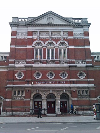
105 Barking Road is a former public hall in Canning Town, in the London Borough of Newham, in the United Kingdom. The building is situated in the ward of Canning Town South, on the north of Barking Road, to the northeast of Canning Town station. 105 Barking Road is a classic example of a Victorian town hall with links to East London's suffragette and labour movements during the late nineteenth and early twentieth centuries. The building is a Grade II listed building.
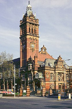
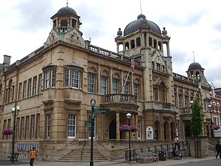
Stratford Town Hall is a municipal building in Stratford, London. It is a Grade II listed building.