
The city of Chihuahua or Chihuahua City is the state capital of the Mexican state of Chihuahua. As of 2020, the city of Chihuahua had a population of 925,762 inhabitants. while the metropolitan area had a population of 988,065 inhabitants.

Hidalgo del Parral is a city and seat of the municipality of Hidalgo del Parral in the Mexican state of Chihuahua. It is located in the southern part of the state, 220 kilometres (140 mi) from the state capital, the city of Chihuahua, Chihuahua. As of 2015, the city of Hidalgo del Parral had a population of 109,510 inhabitants, while the metro area had a population of 129,688 inhabitants. The city was founded as San José del Parral. The name was changed after independence from Spain, in honour of Fr Miguel Hidalgo, widely considered the 'Father of the Country'.
Creel is a town in the Sierra Tarahumara of the Mexican state of Chihuahua. It is the second-largest town in the municipality of Bocoyna. It is located some 175 kilometres (109 mi) to the southwest of the state capital, Chihuahua City. At the census of 2010, it had a population of 5,026, down from 5,338 as of 2005. It is notable for being inhabited mostly by Native Americans of the Rarámuri ethnic group, and the use of their native language is widespread in the population in daily life and public events such as church masses.

Santa Rosalía de Camargo, originally called Santa Rosalía, and now known as "Ciudad Camargo", is a city in the eastern part of the Mexican state of Chihuahua, located at the confluence of the Rio Parral and the Rio Conchos in the Allende Valley. It serves as the municipal seat of Camargo municipality and also serves as an important agricultural and livestock center for the area. Ciudad Camargo was originally founded in 1740 and refounded in 1792.
Delicias is a city in the Mexican state of Chihuahua and serves as the seat of the municipality of the same name. It is located southeast of the state capital, Chihuahua. Delicias was declared an official municipality of the state of Chihuahua on January 7, 1935. Delicias is a small industrial city and a major agricultural center located in the Conchos River Valley. As of 2015, the city of Delicias had a population of 148,045 inhabitants, while the metropolitan area had a population of 223,993 inhabitants. It was founded on 30 April 1933, making it one of Mexico's youngest cities. The municipality of Delicias is one of the smallest in the state in terms of size area.

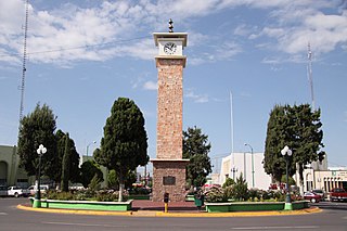
Cuauhtémoc is a city located in the west-central part of the Mexican state of Chihuahua. It serves as the seat of the municipality of Cuauhtémoc. The city lies 103 km (64 mi) west of the state capital of Chihuahua. As of 2015, the city of Cuauhtémoc had a population of 168,482. 3 languages are recognized as official in the city: Spanish, English, and Plautdietsch.

A cavalcade is a procession or parade on horseback, or a mass trail ride by a company of riders. The focus of a cavalcade is participation rather than display. Often, the participants do not wear costumes or ride in formation. Often, a cavalcade re-enacts an important historical event and follows a long-distance trail. A cavalcade may also be a pilgrimage.
Ixtapan del Oro is a town and municipality in the State of Mexico, in Mexico. The name “Ixtapan” comes from Nahuatl and means 'in the place of little salt'. "del Oro" is Spanish, meaning 'of the gold'. This name was added in 1894 when some veins of gold were found here.

Práxedis Gilberto Guerrero is the municipal seat of the municipality of Práxedis G. Guerrero in the northern Mexican state of Chihuahua.
The Church of the Firstborn is a grouping of competing factions of a Mormon fundamentalist religious lineage inherited, adherents believe, by a polygamous family community that had settled in Chihuahua, Mexico, by Alma Dayer LeBaron Sr. by 1924.
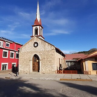
Casas Grandes Municipality is located in the northern Mexican state of Chihuahua. The municipal seat is the town of Casas Grandes, Chihuahua.

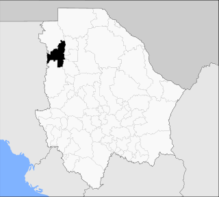
Ahumada is one of the 67 municipalities of Chihuahua, in northern Mexico. The municipal seat lies at Villa Ahumada. The municipality covers an area of 17,131.5 km².

Nonoava is one of the 67 municipalities of Chihuahua, in north-western Mexico. The municipal seat lies at Nonoava. The municipality covers an area of 2,693.3 km2.
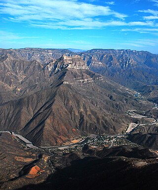
Urique is a town and seat of the municipality of Urique, in the northern Mexican state of Chihuahua. As of 2010, the town of Urique had a population of 1,102, up from 984 as of 2005. Located in the southwest corner of the state in the region of the cliffs, the town is at the bottom of the valley Barranca de Urique, formed by the river of the same name, due to its relatively low elevation above sea level the climate of Urique is close to tropical. It's the principal village of the Municipality of Urique.

The Seventh Federal Electoral District of Chihuahua(VII Distrito Electoral Federal de Chihuahua) is one of the 300 Electoral Districts into which Mexico is divided for the purpose of elections to the federal Chamber of Deputies and one of nine such districts in the state of Chihuahua.

The Ninth Federal Electoral District of Chihuahua(IX Distrito Electoral Federal de Chihuahua) is one of the 300 Electoral Districts into which Mexico is divided for the purpose of elections to the federal Chamber of Deputies and one of nine such districts in the state of Chihuahua.
Federal Highway 10 is a free part of the federal highways corridors of Mexico.

Chihuahua, officially the Estado Libre y Soberano de Chihuahua, is one of the 31 states which, along with Mexico City, comprise the 32 federal entities of Mexico. It is located in the northwestern part of Mexico and is bordered by the states of Sonora to the west, Sinaloa to the southwest, Durango to the south, and Coahuila to the east. To the north and northeast, it shares an extensive border with the U.S. adjacent to the U.S. states of New Mexico and Texas. Its capital city is Chihuahua City; the largest city is Ciudad Juárez.

The Chihuahua is a Mexican breed of toy dog. It is named for the Mexican state of Chihuahua and is among the smallest of all dog breeds. It is usually kept as a companion animal or for showing.
The following is a timeline of the history of the city of Chihuahua, Mexico.


