Norris, South Dakota | |
|---|---|
 Norris, South Dakota  Norris, South Dakota | |
| Coordinates: 43°28′20″N101°11′34″W / 43.47222°N 101.19278°W | |
| Country | United States |
| State | South Dakota |
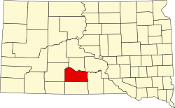
| County | Mellette |
| Area | |
• Total | 0.83 sq mi (2.15 km2) |
| • Land | 0.83 sq mi (2.15 km2) |
| • Water | 0 sq mi (0.00 km2) |
| Elevation | 2,494 ft (760 m) |
| Population | |
• Total | 150 |
| • Density | 180.7/sq mi (69.75/km2) |
| Time zone | UTC-6 (Central (CST)) |
| • Summer (DST) | UTC-5 (CDT) |
| ZIP code | 57560 |
| Area code | 605 |
| FIPS code | 46-45460 [4] |
| GNIS feature ID | 2584562 [2] |
Norris is an unincorporated community in Mellette County, South Dakota, United States. It is not specifically tracked by the Census Bureau, but is included in the census-designated place of the same name. The population of the CDP was 150 at the 2020 census. [5] Norris has a post office that serves the 57560 ZIP code area. The zip code includes the town of Corn Creek.
Norris was laid out in 1910 and named after a nephew of the town's merchant. [6]