Related Research Articles

Somerset County is a county in the state of Maine, United States. As of the 2020 census, the population was 50,477. Its county seat is Skowhegan.

Harpswell is a town in Cumberland County, Maine, United States, within Casco Bay in the Gulf of Maine. The population was 5,031 at the 2020 census. Harpswell is composed of land contiguous with the rest of Cumberland County, called Harpswell Neck, as well as three large islands connected by bridges: Sebascodegan Island, Orr's Island, and Bailey Island and over 200 smaller islands. Harpswell is part of the Portland–South Portland–Biddeford, Maine Metropolitan Statistical Area.
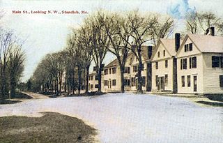
Standish is a town in Cumberland County, Maine, United States. The population was 10,244 at the 2020 census. It includes the villages of Standish Corner, Sebago Lake Village and Steep Falls, and the localities known as Richville, Elmwood, Standish Neck and Two Trails. Standish is part of the Portland-South Portland-Biddeford, Maine metropolitan statistical area.

Windham is a town in Cumberland County, Maine, United States. The population was 18,434 at the 2020 census. It includes the villages of South Windham and North Windham. It is part of the Portland–South Portland–Biddeford, Maine Metropolitan Statistical Area.

Corinna is a town in Penobscot County, Maine, United States. The population was 2,221 at the 2020 census. It is part of the Bangor metropolitan statistical area. The village of Corinna is in the southern part of the town.

Monson is a town in Piscataquis County, Maine, United States. The population was 609 at the 2020 census. The town is located on Route 15 which is a significant route north into the well known Moosehead Lake Region, to which Monson can be considered a gateway. This route eventually leads to the Canadian Province of Quebec.

Solon is a town in Somerset County, Maine, United States. The population was 978 at the 2020 census.

Morrill is a town in Waldo County, Maine, United States. The population was 971 at the 2020 census.

Dayton is a town in York County, Maine, United States; the town is located near the Saco-Biddeford city area. Dayton borders Biddeford by land, and borders Saco on the Saco River. It is also part of the Portland–South Portland–Biddeford, Maine metropolitan statistical area. The population was 2,129 at the 2020 census. Dayton is one of the smallest towns in York County.

U.S. Route 201 is part of the nationwide system of United States Numbered Highways. It runs for 157.46 miles (253.41 km) entirely within the state of Maine and is a spur route of U.S. Route 1. Its southern terminus is in Brunswick at US 1 and Maine State Route 24 Business. Its northern terminus is at the Canada–US border near Jackman, where it connects to Quebec Route 173.
Maine School Administrative District are school districts in Maine. There are a total of 52 MSADs.
The Nashua River Rail Trail is a 12.5-mile (20.1 km) paved mixed-use rail trail in northern Massachusetts and southern New Hampshire under control of the Massachusetts Department of Conservation and Recreation (DCR). It roughly follows the course of the Nashua River, passing through the towns of Ayer, Groton, Pepperell, and Dunstable, Massachusetts and ends about a mile across the New Hampshire state border in Nashua, New Hampshire. The trail is used by walkers, cyclists, inline skaters, equestrians, and cross-country skiers.

The Air Line State Park Trail is a rail trail and linear state park located in Connecticut. The trail is divided into sections designated South, North a piece of the East Coast Greenway, and the Thompson addition. An additional 3.6-mile spur to Colchester is sometimes designated as part of the Air Line trail. At the Massachusetts state line, the trail connects to the Southern New England Trunkline Trail, a 22-mile-long trail to Franklin, MA built on the same right-of-way. Since 2018, the town of Portland, CT has also maintained a 2.3-mile portion of the Air Line trail, connecting to the southern end of the state park at the town line with East Hampton.
The Eastern Railroad was a railroad connecting Boston, Massachusetts to Portland, Maine. Throughout its history, it competed with the Boston and Maine Railroad for service between the two cities, until the Boston & Maine put an end to the competition by leasing the Eastern in December 1884. Much of the railroad's main line in Massachusetts is used by the MBTA's Newburyport/Rockport commuter rail line, and some unused parts of its right-of-way have been converted to rail trails.

The Somerset Railroad was built to serve Kennebec River communities and later extended through timberlands to a large wooden Victorian era destination hotel on Moosehead Lake. The railway became part of the Maine Central Railroad in 1911; and a portion remained in intermittent operation by Pan Am Railways until 2013.

Pepperell is a town in Middlesex County, Massachusetts, United States. The population was 11,604 at the 2020 census. It includes the village of East Pepperell. Pepperell is home to the Pepperell Center Historic District, a covered bridge, and the 1901 Lawrence Library. The library has a collection of Sidney M. Shattuck’s (1876–1917) stuffed birds.
Regional School Unit 74, formerly Maine School Administrative District 74, is an operating school district within Somerset County, Maine, covering the towns of Anson, Embden, New Portland, North Anson and Solon.

Gorham is a town in Cumberland County, Maine, United States. The population was 18,336 at the 2020 United States Census. In addition to its urban village center known as Gorham Village or simply "the Village," the town encompasses a number of smaller, unincorporated villages and hamlets with distinct historical identities, including South Gorham, West Gorham, Little Falls, White Rock, and North Gorham. Gorham is home to one of the three campuses of the University of Southern Maine. In 2013, Gorham was voted second-best town in Maine after Hampden by a financial website.

Yarmouth is a town in Cumberland County, Maine, United States, twelve miles north of the state's largest city, Portland. When originally settled in 1636, as North Yarmouth, it was part of the Massachusetts Bay Colony, and remained part of its subsequent incarnations for 213 years. In 1849, twenty-nine years after Maine's admittance to the Union as the twenty-third state, it was incorporated as the Town of Yarmouth.
Anson is a town in Somerset County, Maine, United States. The population was 2,291 at the time of the 2020 census. It includes the villages of Anson and North Anson.
References
- ↑ "History of Anson, Maine" From A Gazetteer of the State of Maine, By Geo. J. Varney Published by B. B. Russell, 57 Cornhill, Boston 1886
- ↑ "- YouTube". YouTube .
