North Frontenac, Ontario

Last updated
North Frontenac
Township of North Frontenac
Plevna ON.JPG
Plevna
Canada Southern Ontario location map 2.png
Red pog.svg
North Frontenac
Location in southern Ontario
Coordinates: 44°57′N76°54′W / 44.950°N 76.900°W / 44.950; -76.900 Coordinates: 44°57′N76°54′W / 44.950°N 76.900°W / 44.950; -76.900
Country Canada
Province Ontario
County Frontenac
Incorporated1998
Government
  TypeTownship
  MayorRon Higgins [1]
  Deputy MayorFred Perry [1]
  Prov. riding Lanark—Frontenac—Lennox and Addington
  Federal riding Lanark—Frontenac—Lennox and Addington
Area
[2]
  Land1,164.77 km2 (449.72 sq mi)
Population
 (2016) [2]
  Total1,898
  Density1.6/km2 (4/sq mi)
Time zone UTC-5 (EST)
  Summer (DST) UTC-4 (EDT)
Postal Code
K0H
Area code(s) 613, 343
Website www.northfrontenac.com OOjs UI icon edit-ltr-progressive.svg

North Frontenac is a township in Frontenac County in eastern Ontario, Canada.

Contents

History

North Frontenac was created in 1998 by the amalgamation of three municipalities: the Township of Barrie; the Township of Clarendon and Miller; and the Township of Palmerston, North and South Canonto.

Geography

North Frontenac is in the heart of eastern Ontario's cottage country. Cottages and campsites dot the shores of the Township's many clean lakes. Located entirely on the Canadian Shield, the landscape can often be rough and unpredictable, but at the same time provides scenic vistas. Residents, both permanent and seasonal, enjoy a wide variety of outdoor activities.

Communities

The township includes the communities of Ardoch, Beatty, Beech Corners, Canonto, Coxvale, Donaldson, Fernleigh, Harlowe, Mississippi Station, Myers Cave, Ompah, Plevna, Robertsville, Snow Road Station and Wilbur.

Old store sign in Ompah Ompah ON.JPG
Old store sign in Ompah

Demographics

The Township of North Frontenac is a 1,164.73 square km lower-tier municipality, part of Frontenac County, and home to over 1,842 permanent residents. In addition, there are an estimated 5,000 seasonal residents. The low density of the population (1.7 people per km2) makes for the preservation of a scenic landscape. North Frontenac is set in the heart of eastern Ontario's cottage country. For these reasons it is one of the best destinations for outdoor activities and relaxing living in southeastern Ontario.

Canada census – North Frontenac, Ontario community profile
2016 2011 2006
Population:1,898 (+2.2% from 2011)1,857 (-2.5% from 2006)1,904 (+5.7% from 2001)
Land area:1,164.77 km2 (449.72 sq mi)1,164.73 km2 (449.70 sq mi)1,135.75 km2 (438.52 sq mi)
Population density:1.6/km2 (4.1/sq mi)1.6/km2 (4.1/sq mi)1.7/km2 (4.4/sq mi)
Median age:54.1 (M: 53.9, F: 54.4)54.9 (M: 53.5, F: 55.9)
Total private dwellings:2,9662,8233,107
Median household income:$51,942$37,035
References: 2016 [3] 2011 [4] 2006 [5] earlier [6]

According to the 2016 Statistics Canada Census: [2]

Historical population
YearPop.±%
1996 1,773    
2001 1,801+1.6%
2006 1,904+5.7%
2011 1,857−2.5%
2016 1,898+2.2%
[7] [8] [2]

Populations prior to amalgamation (1998):

Local government

North Frontenac is governed by a mayor, a deputy mayor who serves as both mayor and councillor and five councillors. Each municipal ward is represented by two councillors. The deputy mayor serves as both councillor of Ward 1 and deputy mayor. The Mayor of North Frontenac represents the town on the Frontenac County Council, which consists of four mayors, each with a chosen councillor from their township. [9] As of the 2018 election, the elected council members are: [10]

List of former mayors

Mayors of the Township of North Frontenac:

See below for the reeves of the pre-amalgamated townships of North Frontenac.

Reeves of the former Township of Barrie

  • 1873–1873: T. TAPPING
  • 1874–1874: D. KENYON
  • 1875–1875: D. KENYON
  • 1876–1878: T. TAPPING
  • 1879–1881: R. SCOTT
  • 1882–1882: T. TAPPING
  • 1883–1883: R. TAPPING
  • 1884–1886: A. WICKWARE
  • 1887–1887: Wm. DEMPSEY
  • 1888–1893: T. TAPPING
  • 1894–1894: G. DELINE
  • 1895–1895: G. DELINE
  • 1896–1896: Wm. SALMOND
  • 1897–1897: G. DELINE
  • 1898–1898: J. MITCHELL
  • 1899–1899: J. MITCHELL
  • 1900–1900: G. DELINE / Wm. SALMOND
  • 1901–1904: Wm. SALMOND
  • 1905–1905: G. DELINE
  • 1906–1906: G. DELINE
  • 1907–1909: C. MACGREGOR
  • 1910–1913: Wm. SALMOND
  • 1914–1917: J. GRAY
  • 1918–1926: C. MACGREGOR
  • 1927–1933: S. WHEELER
  • 1934–1942: H. LEVERE
  • 1943–1951: A. MACGREGOR
  • 1952–1952: A. HILLIER
  • 1953–1957: J. HEAD
  • 1958–1966: J. HILL
  • 1967–1988: T. NEAL
  • 1989–1990: W. VAN KEMPEN
  • 1991–1997: T. NEAL

Amalgamated in 1998 and now exists as Ward 1 of The Township of North Frontenac.

Reeves of the former Township of Clarendon and Miller

  • 1865–1882: B. WATKINS. Bram Watkins was one of the first settlers in Clarendon. [11]
  • 1883–1885: J. HOWELL
  • 1886–1891: J. HOWELL
  • 1892–1892: B. WATKINS
  • 1893–1896: A. MONROE
  • 1897–1900: J.F. CARD
  • 1901–1901: B. WATKINS
  • 1902–1904: J. MCDONALD
  • 1905–1905: S.S. BARTON
  • 1906–1906: J. MCDONALD
  • 1907–1907: J. MCDONALD
  • 1908–1912: J.D. GODKIN
  • 1913–1913: J.F. CARD
  • 1914–1914: J.F. CARD
  • 1915–1919: P.J. WENSLEY
  • 1920–1922: T. ARMSTRONG
  • 1923–1928: J. FLAKE
  • 1929–1931: J. BROUSE
  • 1932–1934: J. FLAKE
  • 1935–1951: L. KRING
  • 1952–1954: C. ARMSTRONG
  • 1955–1955: L. KRING
  • 1956–1956: G. KRING
  • 1957–1957: C. ARMSTRONG
  • 1958–1974: G. KRING
  • 1975–1984: WM. FLIELER
  • 1985–1997: S. JOHNSTON

Amalgamated in 1998, a now exists as Ward 2 of The Township of North Frontenac.

Reeves of the former Township of Palmerston, North and South Canonto

  • 1896–1901: J. MCKENZIE
  • 1902–1902: P. WHITE
  • 1903–1903: J. MOORE
  • 1904–1904: R. WOOD
  • 1905–1905: WM. MILLAR
  • 1906–1908: D. WOOD
  • 1909–1909: WM. DONALDSON
  • 1910–1910: D. WOOD
  • 1911–1915: WM. DONALDSON
  • 1916–1924: D. GEMMILL
  • 1925–1932: S.J. SHANKS
  • 1933–1949: A.C. RHODES
  • 1950–1952: W.B. CAMERON
  • 1953–1972: A. TROMBLEY
  • 1973–1976: R. RYDER
  • 1977–1988: B. SPROULE
  • 1989–1991: B. CARNELL
  • 1992–1997: B. SPROULE

Amalgamated in 1998, and now exists as Ward 3 of The Township of North Frontenac.

See also

Related Research Articles

Scugog Township in Ontario, Canada

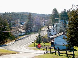
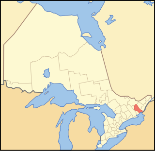
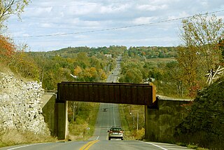
Scugog is a township in the Regional Municipality of Durham, south-central Ontario, Canada. It is northeast of Toronto and just north of Oshawa. Due to its location in the Greater Toronto Area, many residents commute to Toronto for work on a daily basis. The anchor and largest population base of the township is Port Perry. The township has a population of roughly 22,500. A smaller Scugog Township was also a historic municipality and geographic township prior to the amalgamation that formed the current municipality.

Georgina, Ontario Town in Ontario, Canada

Georgina is a town in south-central Ontario, and the northernmost municipality in the Regional Municipality of York. The town is bounded to the north by Lake Simcoe. Although incorporated as a town, it operates as a township in which dispersed communities share a common administrative council. The largest communities are Keswick, Sutton and Jackson's Point. Smaller communities include Pefferlaw, Port Bolster, Roches Point, Udora and Willow Beach. The town was formed by the merger of the Village of Sutton, the Township of Georgina and the Township of North Gwillimbury in 1971 and incorporated in 1986. North Gwillimbury had previously been part of Georgina but became its own township in 1826. It took its name from the family of Elizabeth Simcoe, née Gwillim.

Brock, Ontario Township in Ontario, Canada

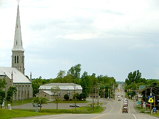
Brock is a township in the Regional Municipality of Durham, Ontario, Canada. Brock Township is also a former municipality and geographic township prior to the amalgamation that formed the current municipality.

Kawartha Lakes City in Ontario, Canada

The City of Kawartha Lakes is a unitary municipality in Central Ontario, Canada. It is a municipality legally structured as a single-tier city; however, Kawartha Lakes is the size of a typical Ontario county and is mostly rural. It is the second largest single-tier municipality in Ontario by land area.

Hastings County County in Ontario, Canada

Hastings County is located in the province of Ontario, Canada. Geographically, it is located on the border of Eastern Ontario and Central Ontario. Hastings County is the second largest county in Ontario. The county seat is Belleville, which is independent of Hastings County. Hastings County has trademarked the moniker "Cheese Capital of Canada".

Innisfil Town in Ontario, Canada

Innisfil is a town in Ontario, Canada, located on the western shore of Lake Simcoe in Simcoe County, immediately south of Barrie and 80 kilometres (50 mi) north of Toronto. It has historically been a rural area, but due to being geographically sandwiched in between the high-growth areas of Barrie area and York Region has meant greater residential development in Innisfil.

Essa, Ontario Township in Ontario, Canada

Essa is a township in Ontario, Canada, west and south of the city of Barrie in Simcoe County. It is bounded by County Road 90 to its north, County Road 27 to its east, and Ontario Highway 89 to its south. The township is about 100 kilometres (62 mi) from Toronto. The township is well known for its agriculture industry, particularly potato farming. Nearby CFB Borden brings a strong military presence to the area as well, including a high number of Francophone families.

Renfrew County County in Ontario, Canada

Renfrew County is a county in the Canadian province of Ontario. It stands on the west bank of the Ottawa River. There are 17 municipalities in the county.

Kincardine, Ontario Municipality in Ontario, Canada

Kincardine is a municipality located on the shores of Lake Huron in Bruce County in the province of Ontario, Canada. The current municipality was created in 1999 by the amalgamation of the Town of Kincardine, the Township of Kincardine, and the Township of Bruce.

Central Frontenac Township in Ontario, Canada

Central Frontenac is a township in eastern Ontario, Canada in the County of Frontenac.

Havelock-Belmont-Methuen Township in Ontario, Canada

Havelock-Belmont-Methuen is a township in central-eastern Ontario, Canada; in Peterborough County. On January 1, 1998; Belmont and Methuen Township amalgamated with the Village of Havelock to form what is now Havelock-Belmont-Methuen.

Douro-Dummer Township in Ontario, Canada

Douro-Dummer is a township in central-eastern Ontario, Canada, in Peterborough County along the Trent-Severn Waterway. It was formed on January 1, 1998, through the amalgamation of Douro and Dummer Townships.

Frontenac County County in Ontario, Canada

Frontenac County is a county and census division of the Canadian province of Ontario. It is located in the eastern portion of Southern Ontario. The city of Kingston is in the Frontenac census division, but is separated from the County of Frontenac.

South Frontenac Township in Ontario, Canada

South Frontenac is a township in Frontenac County in eastern Ontario, Canada. It was amalgamated in 1998 from the former townships of Bedford, Loughborough, Portland, and Storrington.

Minden Hills Township in Ontario, Canada

Minden Hills is a township in and the county seat of Haliburton County, Ontario, Canada. It is an amalgam of the townships of Snowdon, Lutterworth, Anson, Hindon and Minden. It is usually referred to as Minden, after its largest community.

Frontenac—Lennox and Addington was a federal electoral district represented in the House of Commons of Canada from 1968 to 1979. It was located in the province of Ontario. This riding was created in 1966 from parts of Hastings—Frontenac, Kingston, Lanark, Prince Edward—Lennox, Renfrew North and Renfrew South ridings.

Guelph/Eramosa Township in Ontario, Canada

Guelph/Eramosa is a township located in Wellington County, in midwestern Ontario, Canada. It partly encircles the city of Guelph, surrounding it in a continuous arc from approximately northeast to south-southwest of the city. It is part of the Guelph census metropolitan area.

Shuniah Municipality in Ontario, Canada

Shuniah is a municipal township bordering the city of Thunder Bay, Ontario, Canada on the east. Shuniah was incorporated by an act of the Ontario legislature in 1873, and at that time included much of present-day Thunder Bay and its predecessor and surrounding municipalities. It gradually shrunk in size until by 1936 it included only three wards, the geographic townships of McIntyre, McGregor, and McTavish. That year it had the Ontario Legislative Assembly remove a number of islands in Lake Superior that had formed the Island Ward since 1873. In 1970 McIntyre Township was amalgamated into the city of Thunder Bay. Shuniah, named after the Ojibwa word "zhooniyaa" for "money" or "silver", was settled largely due to silver mining potential identified in the mid-19th century.

South Stormont Township in Ontario, Canada

South Stormont is a township in eastern Ontario, Canada, in the United Counties of Stormont, Dundas and Glengarry. It is located 53 kilometres (33 mi) southeast of Ottawa. South Stormont borders on, but does not include, the city of Cornwall.

Addington was an provincial electoral riding in Ontario, Canada. It was created in 1867 at the time of confederation and was abolished in 1954 before the 1955 election.

References

  1. 1 2 "Mayor and Councillors of North Frontenac Township". Township of North Frontenac. Retrieved 2018-12-07.
  2. 1 2 3 4 "Census Profile, 2016 Census: North Frontenac, Township". Statistics Canada . Retrieved June 13, 2019.
  3. "2016 Community Profiles". 2016 Canadian Census . Statistics Canada. February 21, 2017. Retrieved 2019-06-13.
  4. "2011 Community Profiles". 2011 Canadian Census . Statistics Canada. July 5, 2013. Retrieved 2012-02-13.
  5. "2006 Community Profiles". 2006 Canadian Census . Statistics Canada. March 30, 2011. Retrieved 2012-02-13.
  6. "2001 Community Profiles". 2001 Canadian Census . Statistics Canada. February 17, 2012.
  7. Statistics Canada: 1996, 2001, 2006 census
  8. "North Frontenac census profile". 2011 Census of Population . Statistics Canada. Retrieved 2012-02-13.
  9. "County Council". www.frontenaccounty.ca. 2018. Retrieved December 7, 2018.
  10. "Mayor and Councillors of North Frontenac Township". Northfrontenac.com. December 4, 2018. Retrieved December 7, 2018.
  11. Armstrong, C.A. (1976). Away Back in Clarendon and Miller. Renfrew, Ontario: General Store Publishing House. p. 104. ISBN   1-894263-97-9.