
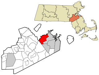
Quincy is a coastal U.S. city in Norfolk County, Massachusetts, United States. It is the largest city in the county and a part of Metropolitan Boston as one of Boston's immediate southern suburbs. Its population in 2020 was 101,636, making it the seventh-largest city in the state. Known as the "City of Presidents", Quincy is the birthplace of two U.S. presidents—John Adams and his son John Quincy Adams—as well as John Hancock, the first signer of the Declaration of Independence and the first and third governor of Massachusetts.
Milton is a town in Norfolk County, Massachusetts, United States and an affluent suburb of Boston. The population was 28,630 at the 2020 census. Milton is the birthplace of former U.S. President George H. W. Bush, and architect Buckminster Fuller. Milton was ranked by Money as the 2nd, 7th, 8th, and 17th best place to live in the United States in 2011, 2009, 2019, 2021, and 2022 respectively.

Dorchester is a Boston neighborhood comprising more than 6 square miles (16 km2) in the City of Boston, Massachusetts, United States. Originally, Dorchester was a separate town, founded by Puritans who emigrated in 1630 from Dorchester, Dorset, England, to the Massachusetts Bay Colony. This dissolved municipality, Boston's largest neighborhood by far, is often divided by city planners in order to create two planning areas roughly equivalent in size and population to other Boston neighborhoods.
The Neponset River is a river in eastern Massachusetts in the United States. Its headwaters are at the Neponset Reservoir in Foxborough, near Gillette Stadium. From there, the Neponset meanders generally northeast for about 29 miles (47 km) to its mouth at Dorchester Bay between Quincy and the Dorchester section of Boston, near the painted gas tank.

Mattapan is a neighborhood in Boston, Massachusetts. Historically and for legal processes a section of Dorchester, Mattapan became a part of Boston when Dorchester was annexed in 1870. Mattapan is the original Native American name for the Dorchester area, possibly meaning "a place to sit." At the 2010 census, it had a population of 36,480, with the majority of its population immigrants.

Dorchester Avenue is a street in Boston, Massachusetts, running from downtown south via South Boston and Dorchester to the border with Milton, where it ends. Built as a turnpike, the Dorchester Turnpike, it is mostly straight.

Quincy Adams station is a rapid transit station in Quincy, Massachusetts. It serves the Braintree Branch of the MBTA's Red Line. Located in southern Quincy on Burgin Parkway near the Braintree Split, the station features a large park and ride garage, with space for 2,538 automobiles, built over the station tracks and platforms. It is fully accessible.

The Thomas Crane Public Library (TCPL) is a city library in Quincy, Massachusetts. It is noted for its architecture. It was funded by the Crane family as a memorial to Thomas Crane, a wealthy stone contractor who got his start in the Quincy quarries. The Thomas Crane Library has the second largest municipal collection in Massachusetts after the Boston Public Library.

Quincy Center station is an intermodal transit station in Quincy, Massachusetts. It is a transfer station between the MBTA Red Line subway, MBTA Commuter Rail's Old Colony Lines and Greenbush Line, and a number of MBTA bus routes. It is located between Hancock Street and Burgin Parkway in the Quincy Center district. Opened in 1971, the station was covered by a large parking garage which was closed in 2012 due to structural problems and removed several years later. The station is accessible on all modes.

North Quincy station is an MBTA subway Red Line station in Quincy, Massachusetts. It is located in North Quincy, off Hancock Street. A major park-and-ride stop, it has over 1200 parking spaces for commuters. The station is fully accessible.

Wollaston station is a rapid transit station in Quincy, Massachusetts. Located in the Wollaston neighborhood, it serves the MBTA's Red Line. It was opened in September 1971 as the second of three stations in the original South Shore Extension, replacing a mainline rail station which had been located there from 1845 to 1959. Wollaston station was closed from January 8, 2018, to August 16, 2019, for renovations to the station, including flood mitigation and accessibility improvements.

Quincy Point is a neighborhood of Quincy, Massachusetts. "The Point" is generally defined as the land east of Quincy Center, the downtown district. Quincy Point is bordered on the west by Elm Street, on the east by Weymouth Fore River and the Braintree city line, on the north by Town River and on the south by Quincy Avenue. The area altitude averages about 30 feet (9.1 m) above sea level. The population of this neighborhood in 2000 was 11,414.

Quincy Public Schools (QPS) is a school district that manages schools in Quincy, Massachusetts, USA. The superintendent is Kevin W. Mulvey, It serves a population of approximately 94,470 of whom approx. 11% are school age.

Montclair is a neighborhood of Quincy, Massachusetts.
Quincy Shore Drive is a historic parkway in Quincy, Massachusetts. The road is one of a series of parkways built by predecessors of the Massachusetts Department of Conservation and Recreation, to provide access to parks and beaches in the Greater Boston area. Its development was proposed in 1893 by Charles Eliot, who promoted the development of many of the area's parks and parkways. Planning began in 1897, with land acquisition following around 1900. Construction of the 4-mile (6.4 km) road was begun in 1903 and completed in 1907.

Furnace Brook Parkway is a historic parkway in Quincy, Massachusetts. Part of the Metropolitan Park System of Greater Boston, it serves as a connector between the Blue Hills Reservation and Quincy Shore Reservation at Quincy Bay. First conceived in the late nineteenth century, the state parkway is owned and maintained by the Massachusetts Department of Conservation and Recreation (DCR) and travels through land formerly owned by the families of John Adams and John Quincy Adams, passing several historic sites. It ends in the Merrymount neighborhood, where Quincy was first settled by Europeans in 1625 by Captain Richard Wollaston. The road was started in 1904, completed in 1916 and added to the National Register of Historic Places (NRHP) in 2004.

Squantum is a neighborhood of Quincy, Massachusetts, connected to the mainland by a causeway that crosses over a wetland area of the bay. Often thought of as a peninsula, Squantum proper is technically a barrier island as it is surrounded on all four sides by water and is only connected to the mainland and Moon Island via causeways. Located in the northernmost portion of the city, Squantum is bordered on the north by Dorchester Bay and Boston Harbor, on the east by Moon Island and Quincy Bay, on the south by Quincy Bay and North Quincy, and on the west by the Marina Bay development. The population of the neighborhood in 2000 according to the United States Census Bureau was 2,626. Squantum has scenic, waterfront views of Boston Harbor and the Boston skyline and has many of Quincy’s most expensive homes. Squantum residents are the wealthiest of any neighborhood in Quincy, according to the 2010 United States Census Bureau, and the home ownership rate is approximately 92%. The neighborhood is further characterized by its tree-lined streets, its "island getaway" feel, close-knit community, and its annual Squantum Fourth of July Parade. As described in a 2020 book, "One road leads in and out of a square mile of land that is a playground for children and a haven for adults." Squantum also has one of the largest Irish populations, on a per capita basis, of any neighborhood in the United States
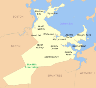
West Quincy is a neighborhood of Quincy, Massachusetts. It is bordered on the north by Wollaston, on the east by Quincy Center, on the south by South Quincy and on the west by the town of Milton and the Blue Hills Reservation. It is known for being a high crime ghetto compared to the rest of Quincy.
Harvard Aviation Field was an airfield operational in the early-20th century in Quincy, Massachusetts.


