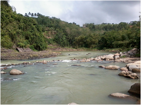
Negros Occidental, officially the Province of Negros Occidental, is a province in the Philippines located in the Negros Island Region. Its capital is the city of Bacolod, of which it is geographically situated and grouped under by the Philippine Statistics Authority, but remains politically independent from the provincial government and also one of the two regional centers in Negros Island Region. It occupies the northwestern half of the large island of Negros, and borders Negros Oriental, which comprises the southeastern half. Known as the "Sugarbowl of the Philippines", Negros Occidental produces more than half the nation's sugar output.

Bacolod, officially the City of Bacolod, is a highly urbanized city in the Negros Island Region in the Philippines. With a total of 600,783 inhabitants as of the 2020 census, it is the most populous city in the Negros Island Region and the second most populous city in the entire Visayas after Cebu City.

Silay, officially the City of Silay, is a component city in the province of Negros Occidental, Philippines. According to the 2020 census, it has a population of 130,478 people.

Talisay, officially the City of Talisay, is a component city in the province of Negros Occidental, Philippines. According to the 2020 census, it has a population of 108,909 people.
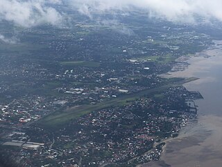
Bacolod City Domestic Airport, also known as Bacolod Airport during its operation, was an airport that served the general area of Bacolod, the capital city of Negros Occidental in the Philippines. It was one of the busiest airports in the Western Visayas region and was one of four trunkline airports, or major commercial domestic airports, in the region, the others being Mandurriao Airport in Iloilo City, Roxas Airport in Roxas and Puerto Princesa Airport in Puerto Princesa. This airport was replaced by the new Bacolod–Silay Airport, located in nearby Silay.
Kabankalan City Domestic Airport is a proposed airport designed to serve the general area of Kabankalan, located in the province of Negros Occidental in the Philippines. The airport would be the second airport in Negros Occidental, after the Bacolod–Silay Airport, and the third airport on the island of Negros. It is located four kilometers northeast of the Kabankalan City Proper on a 100-hectare site in Barangay Hilamonan.

Lake Balinsasayao is one of three crater lakes rising 1,000 feet (300 m) above sea level located within the Balinsasayao Twin Lakes Natural Park, an 8,016.05-hectare (19,808.1-acre) protected area covering the municipalities of Valencia, Sibulan, and San Jose in the province of Negros Oriental, Philippines. The ASEAN Centre for Biodiversity (ACB) is now listed The Balinsasayao Twin Lakes Natural Park among new parks to its network of topnotch nature reserves and natural parks in the Southeast Asian region in 2024.

Metro Bacolod is the 8th-most populous and the 6th-most densely populated metropolitan area out of the 12 metropolitan areas in the Philippines. This metropolitan area as defined by the National Economic and Development Authority (NEDA) has an estimated population of 840,170 inhabitants as of the 2020 official census by the Philippine Statistics Authority.
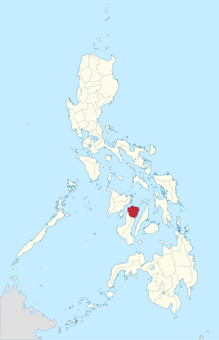
Negros del Norte was a province of the Philippines, located within the Western Visayas region. It existed in 1986 and was abolished later the same year. The law establishing the province was nullified by the Supreme Court of the Philippines on August 18, 1986.
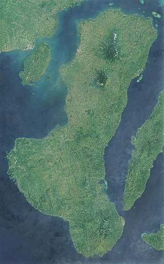
Negros is the fourth largest and third most populous island in the Philippines, with a total land area of 13,309 km2 (5,139 sq mi). The coastal zone of the southern part of Negros is identified as a site of highest marine biodiversity importance in the Coral Triangle.

The Bicol Natural Park is a protected area of the Philippines located in the Bicol Region of southern Luzon. It straddles the mountainous border between the provinces of Camarines Norte and Camarines Sur in the northern interior of the Bicol Peninsula. First declared as a national park covering 4,225 hectares on February 13, 1934, through Proclamation No. 657 of Governor General Frank Murphy, the Bicol National Park was later extended to its present area of 5,201 hectares through amendments made in Proclamation No. 655 signed by President Manuel Luis Quezon on December 23, 1940. The area was reclassified as a natural park on December 29, 2000, by virtue of Proclamation No. 43 by President Joseph Estrada.
Sibalom Natural Park is a 5,511.47-hectare (13,619.1-acre) protected area in the Philippines on the island of Panay in the municipality of Sibalom, Antique. It was proclaimed a natural park on 23 April 2000. It is considered one of the last remaining lowland rainforests on Panay.

The Rajah Sikatuna Protected Landscape is a protected landscape area of forested limestone hills, grasslands and natural springs in the island province of Bohol in the Central Visayas region of the Philippines. It is the largest remaining tract of natural forest in Bohol and one of the Philippines' top birdwatching sites. The park was initially gazetted a national park in 1987 covering approximately 9,023 hectares. In 2000, it was reestablished as a protected landscape under the National Integrated Protected Areas System covering its present area of 10,452.6 hectares. The park is one of the island's major tourist attractions located just south of the famous Chocolate Hills. It was named after the Bohol chieftain who entered into a blood-compact with Spanish conquistador Miguel López de Legazpi on the island in 1565.

The Aliwagwag Protected Landscape is a protected area that preserves a major drainage catchment in the southern Philippine island of Mindanao in the Davao Region. It contains the headwaters of the Cateel River in the southern Diuata Mountain Range which provides the water source and irrigation for surrounding rice fields and communities in Davao de Oro and Davao Oriental provinces. It was named after the remote rural village in the municipality of Cateel where Aliwagwag Falls, the country's highest waterfall, is located.

Balinsasayao Twin Lakes Natural Park is a natural park in the Philippines surrounding Lake Balinsasayao and Lake Danao in the province of Negros Oriental, 14.5 kilometres (9.0 mi) west of Dumaguete. It covers an area of 8,016.05 hectares, with heights ranging from 830 to 846 metres. The park is located in the Mount Talinis range, also known as Cuernos de Negros, in the southern portion of Negros Island, and spans across the municipalities of Valencia, Sibulan and San Jose. It was declared a protected area in 2000. In 2024, the ASEAN Centre for Biodiversity (ACB) is now listed The Balinsasayao Twin Lakes Natural Park among new parks to its network of topnotch nature reserves and natural parks in the Southeast Asian region.
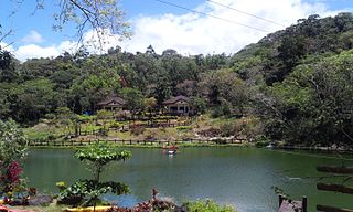
Mambukal Resort, officially the Township of Mambukal or simply known as Mambukal, is a resort township located within the boundaries of the municipality of Murcia, Negros Occidental. As a township, it is directly governed by the Provincial Government of Negros Occidental, which also manages Mambukal Mountain Resort in the 6-hectare townsite near Brgy. Minoyan. The resort is owned and managed by the Provincial Government of Negros Occidental under its Economic Enterprise Development Department.

The Negros Island Region (NIR) is an administrative region in the Philippines. Covering both the islands of Negros and Siquijor, the region is composed of three provinces: Negros Occidental, Negros Oriental, and Siquijor, as well as the highly urbanized city of Bacolod, which is the most populous in the region. The regional centers are Bacolod and Dumaguete.

The Negros Occidental Provincial Board is the Sangguniang Panlalawigan of the Philippine province of Negros Occidental.

The Samar Island Natural Park, in Samar, is the largest contiguous tract of old-growth forest in the Philippines. It is the country's largest terrestrial protected area, with an area of 333,300 hectares. The buffer is spread north to south over the island's three provinces and totals 458,700 hectares, about a third of the entire island of Samar.
Negros Electric and Power Corporation, or simply known as Negros Power, is an electric power distribution company in the Philippines. One of the three major electric power distributors in Negros Occidental, it was incorporated on July 31, 2024 to supersede CENECO. It serves the cities of Bacolod, Talisay, Silay and Bago, and the municipalities of Murcia and Don Salvador Benedicto, all of which are situated in Negros Occidental.
