| Type | Extratropical cyclone Coastal storm |
|---|---|
| Lowest pressure | 946 mb (27.94 inHg) |
| Highest gust | 96 mph (154 km/h) at Confederation Bridge, Prince Edward Island |
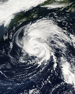
The November 2001 Atlantic Canada storm complex was a powerful coastal storm that included the remnants of North Atlantic hurricanes Michelle and Noel. The low intensified as it moved westward into Atlantic Canada on November 6, reaching a minimum pressure of 946 mbars. The storm turned to the northeast and emerged into the Atlantic Ocean on November 8. It produced strong winds throughout Atlantic Canada, including gusts of up to 96 mph (154 km/h) at the Confederation Bridge in Prince Edward Island. High waves caused damage along the coastlines, while high winds left up to 100,000 without power. Overall damage was minor, and no casualties were reported.
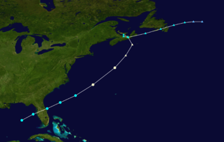
On November 6, an extratropical storm located south of Newfoundland absorbed the remnants of Hurricane Noel. [1] The extratropical storm previously absorbed Hurricane Michelle, [2] and was moving quickly northeastward. [3] The storm complex moved over Newfoundland, [4] intensifying and producing strong winds throughout Atlantic Canada. [2] It exited into the Atlantic Ocean on November 8. [4]
Prior to the passage of the storm, wind warnings were issued in Newfoundland, [5] and throughout the island ferry service was suspended. [4] Ferry service was also canceled in Nova Scotia and Prince Edward Island. [5] Throughout Canada, the storm complex produced powerful winds throughout Atlantic Canada, leaving 100,000 Canadians without power. [2] Environment Canada described the system as one of the top 10 weather events in Canada in 2001. [2]
Winds in Nova Scotia from the storm complex reached 50 mph (80 km/h) in inland areas, while areas near the coast experienced gusts of over 62 mph (100 km/h). [4] The peak wind gust in the province was 93 mph (150 km/h) along Cape George. [3] Strong winds persisted across the province for 19 hours. The storm complex produced 26 to 30-ft (nine to ten m) waves along the eastern and northern coasts of Nova Scotia. The storm surge, which occurred at high tide, reached two ft (0.6 m), eroding a section of the Canso Causeway. The causeway was closed when a trailer overturned from the high winds. [4] Around 1.6 inches (40 mm) of precipitation fell, causing flooding and downed trees. Overall, about 70,000 people in Nova Scotia were left without power. [3]
In New Brunswick, the storm complex produced high winds with gusts of up to 84 mph (135 km/h). The winds downed several trees and power lines which resulted in power outages, [6] with Fredericton being the hardest hit. [4] About 16,000 were without power on the day after the storm struck. [6] The storm produced sustained winds of 76 mph (123 km/h) and gusts to 96 mph (155 km/h) at the Confederation Bridge. There, the wind gust was the highest ever recorded, resulting in the bridge being closed [4] for five hours, [6] the first time the bridge was closed in its history. Waves of up to 30 ft (nine m) in height with a storm surge of over 3.3 ft (one m) hit the northern coastline of Prince Edward Island. Every wharf and many coastal roads from Rustico to East Point were under water from the high waves and storm surge. [4] The winds left much of eastern Prince Edward Island without power. [5]
In Newfoundland, the system produced over four in (100 mm) of rain and strong winds. Many areas reported over 55 mph (90 km/h), with gusts peaking at 84 mph (135 km/h) at Channel-Port aux Basques. Coastal areas of the island reported storm surges of around two ft (0.6 m). The strong winds of the storm destroyed the windows of six vehicles and blew off most of the roof of a truck in Holyrood, with the debris damaging a nearby weather radar. Cold air behind the storm complex produced snow across the island. [4]

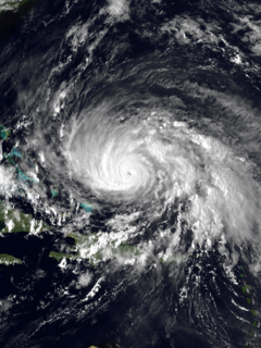
Hurricane Hortense was the first tropical cyclone to make landfall in Guadeloupe and Puerto Rico since Hurricane Hugo in 1989, and the second most intense hurricane during the 1996 Atlantic hurricane season. The eighth tropical cyclone, eighth named storm, and sixth hurricane of the season. Hortense developed on September 3 from a tropical wave in the central Atlantic Ocean.

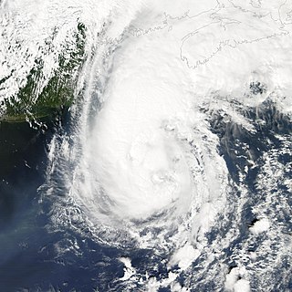
Hurricane Juan was a significant tropical cyclone that heavily damaged parts of Atlantic Canada in late September 2003. Juan is also the first hurricane name and one of two to be requested to be retired by the Meteorological Service of Canada. It was the tenth named storm and the sixth hurricane of the 2003 Atlantic hurricane season. Juan formed southeast of Bermuda on September 24 from a tropical wave that had tracked across the subtropical Atlantic Ocean. It tracked northward and strengthened over the warm waters of the Gulf Stream, reaching Category 2 strength on the Saffir-Simpson hurricane scale on September 27. The hurricane peaked in intensity with sustained winds of 105 mph (165 km/h) that same day, losing some strength as it raced over cooler waters toward the coast of Nova Scotia. Juan made landfall between Shad Bay and Prospect in the Halifax Regional Municipality early on September 29 as a Category 2 hurricane with winds of 100 mph (160 km/h). Juan retained hurricane strength while crossing Nova Scotia from south to north, though it weakened to a Category 1 storm over Prince Edward Island. It was absorbed by another extratropical low later on September 29 near Anticosti Island in the northern Gulf of Saint Lawrence.

The 2001 Atlantic hurricane season was a fairly active Atlantic hurricane season that produced 17 tropical cyclones, 15 named storms, nine hurricanes, and four major hurricanes. The season officially lasted from June 1, 2001, to November 30, 2001, dates which by convention limit the period of each year when tropical cyclones tend to form in the Atlantic Ocean basin. The season began with Tropical Storm Allison on June 4, and ended with Hurricane Olga, which dissipated on December 6. The most intense storm was Hurricane Michelle, which attained Category 4 strength on the Saffir–Simpson Hurricane Scale.
The 1959 Escuminac disaster was considered the worst fishing-related disaster in New Brunswick in 100 years. It occurred due to the extratropical remnants of an Atlantic hurricane. The storm was the third tropical cyclone and first hurricane of the 1959 Atlantic hurricane season, and developed from a tropical wave in the central Gulf of Mexico on June 18. It headed rapidly northeastward and struck Florida later that day. Shortly after entering the Atlantic Ocean, it strengthened into a tropical storm later on June 18. By the following day, it had strengthened into a hurricane. However, it transitioned into an extratropical cyclone about six hours later. The remnants struck Atlantic Canada, once in Nova Scotia and again in Newfoundland before dissipating on June 21.
Hurricane Gloria was the first significant tropical cyclone to strike the northeastern United States since Hurricane Agnes in 1972 and the first major storm to affect New York City and Long Island directly since Hurricane Donna in 1960. It was a powerful Cape Verde hurricane that formed during the 1985 Atlantic hurricane season, originating from a tropical wave on September 16 in the eastern Atlantic Ocean. After remaining a weak tropical cyclone for several days, Gloria intensified into a hurricane on September 22 north of the Lesser Antilles. During that time, the storm had moved generally westward, although it turned to the northwest due to a weakening of the ridge. Gloria quickly intensified on September 24, and the next day reached peak winds of 145 mph (230 km/h). The hurricane weakened before striking the Outer Banks of North Carolina on September 27. Later that day, Gloria made two subsequent landfalls on Long Island and across the coastline of western Connecticut, before becoming extratropical on September 28 over New England. The remnants moved through Atlantic Canada, eventually dissipating on October 2.

The 1943 Atlantic hurricane season marked the first deliberate reconnaissance aircraft flights into tropical cyclones. The season officially lasted from June 16 to October 31, which was, at the time, considered the most likely period for tropical cyclone formation in the Atlantic Ocean. A total of ten storms from 1943 are listed in the Atlantic hurricane database, and an eleventh system that affected Florida and Georgia has been identified as a probable tropical depression. The first system of the year, dubbed the "Surprise hurricane", caused severe damage throughout Texas and Louisiana in June, partially because information about its approach was censored in the fray of World War II; the storm caused 19 deaths and $17 million in damage. A major hurricane in mid-August produced hurricane-force winds in Bermuda, and several other tropical cyclones throughout the year resulted in strong winds there. In September, a hurricane impacted the western Gulf Coast of the United States, then a tropical storm struck the Mid-Atlantic. The two storms resulted in $419,000 and $20,000 in damage, respectively; one death was attributed to the latter system. In mid-October, a strong hurricane resulted in flooding and damage to crops throughout the Caribbean; after becoming post-tropical, it contributed to moderate impacts across Nova Scotia.

The 1923 Atlantic hurricane season featured 11 tropical cyclones, 9 of which intensified into tropical storms, the most since 1916. Four of the tropical storms intensified into hurricanes, one of which reached major hurricane intensity—Category 3 or higher on the modern-day Saffir–Simpson hurricane wind scale. No tropical storms or hurricanes formed in or entered the Caribbean Sea. The first known system, a tropical depression, formed on June 19, while the last known system, a tropical storm, transitioned into an extratropical cyclone on October 26. A total of Additionally, an October tropical depression was previously recognized as a tropical storm until reanalysis in 2009, while the first and third tropical storms were added to the Atlantic hurricane database that year. The sixth, seven, and eight storms as well as the October tropical depression existed simultaneously on October 16.

Hurricane Gladys was the first Atlantic hurricane to be observed each by the Hurricane Hunters, radar imagery, and photographs from space. The seventh named storm and fifth hurricane of the 1968 season, Gladys formed on October 13 in the western Caribbean from a broad disturbance related to a tropical wave. The storm moved north-northwestward, becoming a hurricane before striking Cuba on October 16. Gladys later reached peak winds of 85 mph (140 km/h) just before making landfall near Homosassa on the western coast of Florida on October 19. The hurricane crossed the state and continued northeastward, passing just east of Cape Hatteras on October 20. The next day, Gladys became extratropical and was absorbed by a cold front over Nova Scotia.

The 1991 Perfect Storm, also known as The No-Name Storm and the Halloween Gale/Storm, was a nor'easter that absorbed Hurricane Grace, and ultimately evolved into a small unnamed hurricane itself late in its life cycle. The initial area of low pressure developed off the coast of Atlantic Canada on October 29. Forced southward by a ridge to its north, it reached its peak intensity as a large and powerful cyclone. The storm lashed the east coast of the United States with high waves and coastal flooding before turning to the southwest and weakening. Moving over warmer waters, the system transitioned into a subtropical cyclone before becoming a tropical storm. It executed a loop off the Mid-Atlantic states and turned toward the northeast. On November 1, the system evolved into a full-fledged hurricane, with peak sustained winds of 75 miles per hour (120 km/h), although the National Hurricane Center left it unnamed to avoid confusion amid media interest in the precursor extratropical storm. It later received the name "the Perfect Storm" after a conversation between Boston National Weather Service forecaster Robert Case and author Sebastian Junger. The system was the twelfth and final tropical cyclone, the eighth tropical storm, and fourth hurricane in the 1991 Atlantic hurricane season. The tropical system weakened, striking Nova Scotia as a tropical storm before dissipating.
Hurricane Helene was the most intense tropical cyclone of the 1958 Atlantic hurricane season. The eighth tropical storm and fourth hurricane of the year, Helene was formed from a tropical wave east of the Lesser Antilles on September 21, 1958. Moving steadily westward, the storm slowly intensified, attaining hurricane strength on September 24. As conditions became increasingly favorable for tropical cyclone development, Helene began to rapidly intensify. Nearing the United States East Coast, the hurricane quickly attained Category 4 intensity on September 26, before it subsequently reached its peak intensity with maximum sustained winds of 150 mph (240 km/h) and a minimum barometric pressure of 930 mbar. The intense hurricane came within 10 mi (15 km) of Cape Fear, North Carolina before recurving out to sea. Accelerating northward, Helene gradually weakened, and transitioned into an extratropical cyclone as it passed over Newfoundland on September 29. Helene's extratropical remnants traversed eastwards across the Atlantic Ocean before dissipating near Great Britain on October 4.
Hurricane Gustav was a Category 2 hurricane that paralleled the East Coast of the United States in September 2002 during the 2002 Atlantic hurricane season. It was the seventh named storm and first hurricane of the season. Initially a subtropical depression north of the Bahamas, Gustav passed slightly to the east of the Outer Banks of North Carolina as a tropical storm before moving northeastward and making two landfalls in Atlantic Canada as a Category 1 hurricane. The storm was responsible for one death and $100,000 in damage, mostly in North Carolina. The interaction between Gustav and a non-tropical system produced strong winds that caused an additional $240,000 (2002 USD) in damage in New England, but this damage was not directly attributed to the hurricane.

Hurricane Karen was a hurricane of non-tropical origin that formed in October of the 2001 Atlantic hurricane season. It developed out of the interaction between a cold front and an upper level trough on October 10 located to the south of Bermuda, and quickly strengthened as an extratropical storm. The storm passed near Bermuda on October 12, producing hurricane-force winds on the island. It then organized, becoming a subtropical cyclone on the 12th and a tropical cyclone on the 13th. Karen strengthened to reach 80 mph (130 km/h) winds as a Category 1 hurricane on the Saffir-Simpson Hurricane Scale, and after weakening over cooler waters, it made landfall on Nova Scotia as a tropical storm. It quickly became extratropical.
Tropical Storm Dean was a strong tropical storm that affected at least twelve islands along its path from the tropical Atlantic Ocean to east of Atlantic Canada in August 2001. Dean developed from a tropical wave on August 22 over the Lesser Antilles, and was initially predicted to intensify further to reach hurricane status. However, strong wind shear quickly weakened Dean to cause it to dissipate on August 23. The remnants turned northward, and redeveloped on August 26 to the north of Bermuda. Located over warm waters and in an area of favorable conditions, Dean steadily strengthened while moving to the northeast, and peaked just below hurricane status on August 27 about 465 miles (750 km) southwest of Newfoundland. The storm subsequently weakened over cooler waters, and became extratropical on August 28.

Hurricane Michael of the 2000 Atlantic hurricane season caused moderate damage in Atlantic Canada. The seventeenth tropical cyclone, thirteenth named storm, and eighth hurricane of the season, Michael developed from a non-tropical system to the southwest of Bermuda on October 15. The system was initially subtropical, but rapidly acquired tropical characteristics by October 17. Michael quickly strengthened into a hurricane later that day. By October 20, Michael peaked as a Category 2 hurricane on the Saffir-Simpson hurricane wind scale at a relatively high latitude of 44°N. The storm weakened slightly to a Category 1 hurricane and became extratropical shortly before making landfall in Newfoundland on October 20.

Hurricane Dean was the fourth named storm and second hurricane of the 1989 Atlantic hurricane season. Dean formed on July 31 and reached tropical storm status the following day east of the Leeward Islands. Dean brushed the northern Leeward Islands as a Category 1 hurricane on the Saffir–Simpson Hurricane Scale, bringing light rain but producing no damage, before turning northward and striking Bermuda as a Category 2 hurricane. Dean continued northward before making landfall in southeastern Newfoundland.
Hurricane Bertha caused minor damage in the United States, Bermuda, and Atlantic Canada in July and August 1990. The third tropical cyclone, second named storm, and first hurricane of the 1990 Atlantic hurricane season, Bertha developed from a frontal low pressure area offshore of North Carolina on July 24. Initially subtropical, it slowly acquired tropical characteristics while tracked southeast and then southwestward. By early on July 27, the cyclone was re-classified as a tropical depression. Following its transition, the depression intensified and was upgraded to Tropical Storm Bertha on July 28. The storm then curved northeastward and rapidly strengthened. Bertha became a hurricane early on July 29, though it weakened back to a tropical storm later that day. On the following day, Bertha re-intensified into a hurricane and peaked as an 80 mph (130 km/h) Category 1 hurricane on July 31.

The October 2000 Atlantic Canada storm complex was reported as the worst storm in Prince Edward Island in 30 years. Environment Canada considered as one of the ten most significant weather events in Canada in the year. It moved southeastward from Atlantic Canada in late October 2000, producing high snowfall totals in Maine. It absorbed an unnamed subtropical cyclone, and remained nearly stationary in the Gulf of Maine for over a week. Some locations in Atlantic Canada reported record durations of continuous cloud cover. Daily amounts of rainfall produced flooding in Nova Scotia, while a high storm surge associated with the storm washed out roads in New Brunswick and Prince Edward Island. The storm produced wind gusts that peaked at 104 mph (168 km/h) in Newfoundland, and across the region there were scattered power outages.

Hurricane Carol was one of only three Category 5 Atlantic hurricanes to not have its name be retired, the other name being "Edith" and "Emily". Carol was also the strongest storm of the 1953 Atlantic hurricane season and the first Category 5 hurricane in the Atlantic basin since the 1938 New England hurricane. Carol is also the first named storm to attain Category 5 status. Carol developed on August 28 off the west coast of Africa, although the Weather Bureau did not initiate advisories until five days later. On September 2, Carol attained hurricane status, based on a ship report. It moved northwestward, attaining peak winds of 160 mph (260 km/h), based on reports from the Hurricane Hunters. After weakening, it brushed Bermuda and turned northeastward near New England, passing west of Nova Scotia before making landfall near Saint John, New Brunswick on September 7. While crossing Atlantic Canada, Carol became an extratropical cyclone, which dissipated on September 9 southwest of Greenland.
The 1940 Nova Scotia hurricane swept through areas of Atlantic Canada in mid-September 1940. The fifth tropical cyclone and fourth hurricane of the year, it formed as a tropical depression east of the Lesser Antilles on September 7, though at the time weather observations in the area were sparse, so its formation was inferred. The disturbance gradually intensified throughout much of its early formative stages, attaining tropical storm strength on September 10; further strengthening into a hurricane north of Puerto Rico occurred two days later. Shortly thereafter, the hurricane recurved northward, and reached peak intensity the following day as a Category 2 hurricane with maximum sustained winds of 100 mph (160 km/h) and a minimum barometric pressure of at least 988 mbar. The cyclone steadily weakened thereafter before making landfall on Nova Scotia on September 17 with winds of 85 mph (135 km/h). Moving into the Gulf of Saint Lawrence later that day, the storm transitioned into an extratropical cyclone. The remnant system curved eastward and passed over Newfoundland before dissipating over the Atlantic on September 19.