Nu'ulua

Last updated

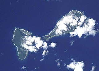
Nu'ulua, not to be confused with Nu'ulua 200 meters west of Ofu, is an island in Samoa in the Aleipata Islands situated more than 1.3 km from the eastern end of Upolu in Samoa.

Ofu-Olosega volcanic doublet in Samoan Islands, American Samoa

Ofu and Olosega are parts of a volcanic doublet in the Manu‘a Group of the Samoan Islands—part of American Samoa. The twin islands, formed from shield volcanoes, have a combined length of 6 km and an area of 12 square kilometers ; their population is about 500 people. They are geographic volcanic remnants separated by the narrow 137-meter-wide (449-foot) Asaga strait, a natural bridge of shallow coral reef. Before 1970, one had to wade between the two islands at low tide; now a single-lane road bridge over the strait connects villages on Ofu island with those on Olosega.

Aleipata Islands archipelago

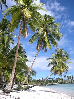
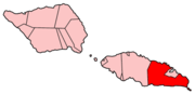
The Aleipata Islands is a group of four uninhabited islands off the eastern end of Upolu Island, Samoa, with an aggregate area of 1.68 km²):

Upolu island in Samoa

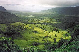
Upolu is an island in Samoa, formed by a massive basaltic shield volcano which rises from the seafloor of the western Pacific Ocean. The island is 75 kilometres long and 1,125 square kilometres in area, making it the second largest of the Samoan Islands geographically. With approximately 145,000 people, it is by far the most populated of the Samoan Islands. Upolu is situated to the southeast of Savai'i, the "big island". Apia, the capital, is in the middle of the north coast, with Faleolo International Airport at the western end of the island. The island has not had any historically recorded eruptions, although three lava flows date back only a few hundred to a few thousand years.

Nu'ulua has a land area of 25 hectares and is a habitat for locally and regionally endemic birds including the endangered tooth-billed pigeon, (Didunculus strigirostris), also known as Samoan pigeon, and an endemic bat (Pteropus samoensis). [1]

Tooth-billed pigeon species of bird

The tooth-billed pigeon, also known as the manumea, is a large pigeon found only in Samoa. It is the only living species of genus Didunculus. A related extinct species, the Tongan tooth-billed pigeon, is only known from subfossil remains in several archeological sites in Tonga. The tooth-billed pigeon is the national bird of Samoa and featured on the 20 tālā bills and the 50 sene pieces of the 2008/2011 series.

Together with Nu'utele, another small island in the Aleipata Islands, the two isles hold the largest seabird colonies in Samoa and identified as highly significant sites for conservation. The conservation project has included efforts to eradicate the presence of Pacific rats (Rattus exulans) which prey on native insects, birds and lizards on the islands. [2]

Nuutele island

Nu'utele is an island which consists of a volcanic tuff ring situated 1.3 km off the eastern end of Upolu island, Samoa. It is the largest of the four Aleipata Islands, at 1.08 km2.

These islets are remnants of eroded volcanic tuff ring. [3]

Volcano A rupture in the crust of a planetary-mass object that allows hot lava, volcanic ash, and gases to escape from a magma chamber below the surface

A volcano is a rupture in the crust of a planetary-mass object, such as Earth, that allows hot lava, volcanic ash, and gases to escape from a magma chamber below the surface.

Ownership of both islands rests with customary chiefly titles in the villages of Aleipata on Upolu.

See also

Related Research Articles

Samoa country in Oceania

Samoa, officially the Independent State ofSamoa and, until 4 July 1997, known as Western Samoa, is a country consisting of two main islands, Savai'i and Upolu, and four smaller islands. The capital city is Apia. The Lapita people discovered and settled the Samoan Islands around 3,500 years ago. They developed a unique Samoan language and Samoan cultural identity.

Geography of Samoa geography of the Independent State of Samoa (and not American Samoa)

The country of Samoa consists of the two large islands of Upolu and Savai'i and eight smaller islands located about halfway between Hawaii and New Zealand in the Polynesian region of the South Pacific Ocean. The island of Upolu is home to nearly three-quarters of Samoa's population and its capital city of Apia. Samoa occupies an almost central position within Polynesia. The climate is tropical, with a rainy season from November to April. To the east is the smaller American Samoa.

Samoan Islands archipelago covering 3,030 km² (1,170 sq mi) in the central South Pacific, forming part of Polynesia and the wider region of Oceania

The Samoan Islands are an archipelago covering 3,030 km2 (1,170 sq mi) in the central South Pacific, forming part of Polynesia and the wider region of Oceania. Administratively, the archipelago comprises all of Samoa and most of American Samoa. The two Samoan jurisdictions are separated by 64 km (40 mi) of ocean.

Savaii Island in the Samoan Islands chain

Savaiʻi is the largest and highest island in Samoa and the Samoan Islands chain. The island is the fifth largest in Polynesia, behind the two main islands of New Zealand and the Hawaiian Islands of Hawaii and Maui.

Mulifanua Village District in Aiga-i-le-Tai, Samoa

Mulifanua is a village on the north-western tip of the island of Upolu, in Samoa. In the modern era, it is the capital of Aiga-i-le-Tai district. Mulifanua wharf is the main ferry terminal for inter-island vehicle and passenger travel across the Apolima Strait between Upolu and the island of Savai'i.

Fanuatapu

Fanuatapu is an uninhabited island which consists of a volcanic tuff ring, situated off the eastern tip of Upolu, Samoa. It is the smallest and easternmost of the four Aleipata Islands, with an area of 15 hectares, and has an automated lighthouse.

Districts of Samoa

Samoa is made up of eleven itūmālō. These are the traditional eleven districts that were established well before European arrival. Each district has its own constitutional foundation (faavae) based on the traditional order of title precedence found in each district's faalupega.

Lalomanu Village in Atua, Samoa

Lalomanu is a village on the east coast of Upolu island in Samoa.The village is part of the electoral constituency Aleipata Itupa i Luga which is within the larger political district of Atua.

Salamumu is a village on the south west coast of Upolu island in Samoa. The village has two settlements, Salamumu Uta and Salamumu Tai.

Fagaloa Bay

Fagaloa Bay is located on the north eastern coast of Upolu island in Samoa. The area is a significant region of conservation and culture. The bay is situated within the political district of Va'a-o-Fonoti.

Lefaga

Lefaga is a village district on the south west coast of the island of Upolu in Samoa. The American movie Return to Paradise (1953), starring Gary Cooper was filmed at Matautu village in Lefaga. The 50th anniversary celebrations of the making of the movie took place in Lefaga in November 2003.

Nu'ulopa is a small uninhabited island in the Apolima Strait between the islands of Upolu and Savai'i in Samoa. The island is part of Aiga-i-le-Tai district.

Nu'usafe'e Island is a small uninhabited island in Samoa. The island is located off the south east coast of Upolu island, near the village of Poutasi.

Gagaifo o le Vao is a village on the island of Upolu in Samoa. It is in the political district of A'ana.

Falefa Valley

Falefa Valley is situated inland on the east side of Upolu Island in Samoa. The area has been excavated and studied by archaeologists, in particular a New Zealand team led by Roger Curtis Green and Janet Davidson. Towards the north of the valley is Falefa village. The valley is situated in the political district of Atua. To the north east is the smaller district of Va'a-o-Fonoti which includes an extensive conservation area.

References

Coordinates: 14°04′22″S171°24′38″W / 14.0728°S 171.4106°W / -14.0728; -171.4106

Geographic coordinate system Coordinate system

A geographic coordinate system is a coordinate system that enables every location on Earth to be specified by a set of numbers, letters or symbols. The coordinates are often chosen such that one of the numbers represents a vertical position and two or three of the numbers represent a horizontal position; alternatively, a geographic position may be expressed in a combined three-dimensional Cartesian vector. A common choice of coordinates is latitude, longitude and elevation. To specify a location on a plane requires a map projection.