Bargarh is an emerging city and municipality in Bargarh district in the state of Odisha in India. It is the administrative headquarters of Bargarh District and is the 13th largest city of Odisha by population.

Santipur is a city and a municipality in the Ranaghat subdivision of Nadia district in the Indian state of West Bengal. The fort area of this city, also known as Daak-Garh is thought to have been built by Raja Krishnachandra of Nadia.

Kalna or Ambika Kalna is a town in the Purba Bardhaman district of West Bengal, India. It is the headquarter of the Kalna subdivision, situated on the western bank of the Bhāgirathi river. The town is more popularly known as Ambika Kalna, named after the goddess Kali, Maa Ambika. It has numerous historical monuments, such as the Rajbari, and 108 Shiva temples. The city of Kalna is 60 kilometres (37 mi) from Bardhaman.
Kendrapara is a Town and a municipality in the Kendrapara district of the Indian state of Odisha. It is the headquarters of Kendrapara district.
Barpali is a small town and a block (Tehsil) within the Bargarh district in the state of Odisha, India. Barpali is largely famous for renowned Odia Poet Swabhaba Kabi Gangadhar Meher who was born here. However, there are several other cultural notations which have made Barpali famous nationally and internationally, like: the indigenous sambalpuri saree weaving art and the earthen pottery handicrafts (Terracotta) etc, creations from the native inhabitants of Barpali. Among others, the name Barpali also draws attention towards the past studies, wide usage and then outward expansion of preliminary versions of sanitary toilets started by foreigners here, known as 'Barpali Toilets' nearly 40 years ago.
Belaguntha or Bellaguntha is a town and a Notified Area Council (N.A.C.) in Odisha, India. It's famously known as The Brass Fish Town.
Bissam Cuttack is a town and Notified Area Council in the Rayagada district of Odisha, India.
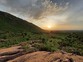
Brajrajnagar is a town and a municipality in Jharsuguda district in the state of Odisha, India. Popular legend says the town was named after Braj Mohan Birla after he set up Orient Paper Mills in 1936. It is a small sleepy town on rocky terrain, built on the banks of IB river, with temples mostly built by the Birlas. Later it became famous for MCL-owned coal mines after Orient Paper Mills of Birlas managed by dulichand Hanuman Prasad shah closed down in 1999.

Domjur is a census town in Domjur CD Block of Howrah Sadar subdivision in Howrah district in the Indian state of West Bengal. It is a part of Kolkata Urban Agglomeration.It is famous for its gold jewellery industries.
Dommara Nandyal is a census town in Mylavaram Mandal, Kadapa district, Andhra Pradesh, India. Dommara Nandyal is under the constituency of Jammalamadugu. Dommara Nandyal is situated along the bank of the Penna River. Mylavaram dam is constructed just 3 km away from it, that supplies water for drinking. Dommara Nandyal is also famous for people making silk sarees with their own hands. Veparala and Moragudi, beside of Dommaranadyala, are also the handloom towns.
Jaleswar is a town located in the Balasore district of Odisha, in India. It consists of 144 villages, with four major areas: Bada Bazar, Nua Bazar, Station Bazar, and Purana Bazar. Jaleswar is considered one of the new municipalities in the state, and Jaleswar forms a state assembly constituency along with Balipal Block.
Kotpad is a town and a notified area committee in Koraput district in the Indian state of Odisha. Nearest railway station to Kotpad is Kotpad Road station which is a part of East Coast railway.

Lodhikheda is a town and a nagar parishad in Pandhurna district in the Indian state of Madhya Pradesh. It is famous for its oranges. More than 90 per cent of farmers produce oranges. Cotton is grown in large quantities in the local area.

Nabadwip, also spelt Navadwip, anciently Nadia or Nudiya, is a heritage city in Nadia district in the Indian state of West Bengal. It is regarded as a holy place by Hindus, and is the birthplace of Chaitanya Mahaprabhu. Famous for Rass festival where city is illuminated with lights, deities of God and goddesses are made on each corner of Nabadwip town. Hundreds of people gather to this small town on the occasion of raas utsab. Located on the western bank of the Hooghly River, it is considered to have been founded in 1063 CE, and served as the old capital of the Sena dynasty. A center of learning and philosophy in medieval India, the city is still noted for its traditional Sanskrit schools. The Navya Nyaya school of logic reached its peak with the efforts of some well known contemporary philosophers of Nabadwip. The great Vaishnava saint, social reformer and an important figure of the Bhakti movement, Chaitanya Mahaprabhu (1486–1534) was born here. It was after Chaitanya Mahaprabhu's birth that Nabadwip became an important center of pilgrimage for the Vaishnavas worldwide as well as for Hindus in general. Many who follow Gaudiya Vaishnavism visit Nabadwip to celebrate the auspicious birthday day of Shri Mahaprabhu, which, as per lunar calculations, occurs on Phalguni Purnima. This day is commonly known as Gaura-purnima. Aside from this, Nabadwip is visited for various other festivals like Dol Jatra and Rash purnima.
Periya Negamam is a panchayat town in Coimbatore district in the southern Indian State of Tamil Nadu. It comes under Pollachi Taluk and pollachi Assembly constituency. Negamam used to be a popular small town serving the commercial and transport needs of many small villages around it until 1980s. With the arrival of frequent city buses to Pollachi and Udumalpet as transportation mode, growth of Negamam remained stunted. Weekly market on Tuesday used to be a big crowd puller.
Tarbha is a Notified Area Council in Subarnapur district in the Indian state of Odisha.
Veeravanallur is a selection grade special panchayat town in the Cheranmahadevi taluk of Tirunelveli district in the Indian state of Tamil Nadu.
Sihaul is a village with population of about 11,000 in the sub-district of Satar Kataiya, where it ranks as the third most populous village. The sub-district forms a part of Saharsa district in the state Bihar, India. The geographical area of the village is 9 km2 (3.5 sq mi) and it is the third biggest village by area in the sub-district. Population density of the village is 1287 persons per km2.
Bangomunda is a tehsil in the Balangir district of Odisha, India with historical importance. It is located 72 km from the district in the town of Balangir. Bangomunda was formerly known as Banganmura which means Brinjal Firm.

Durgi is a census village & Panchayat Headquarter of Bissam Cuttack Block in Rayagada district of Odisha, India. There are total 439 families residing in this village. The wards/ villages comes under Durgi Panchayat are:- Durgi, Bhaleri, Kundanpadar, Rengabai, Barangpadar, Thambalpadhu, Budhanagar, Kachapai, Kalipadar, Kurankul, Tentili Kalipadar, Mulipada, Dharamguda, Balipadar, Haduguda, Huruguda, Khariguda and IAY Colony.


