
The Metropolitan Area Express (MAX) is a light rail system serving the Portland metropolitan area in the U.S. state of Oregon. Owned and operated by TriMet, it consists of five lines connecting the six sections of Portland; the communities of Beaverton, Clackamas, Gresham, Hillsboro, Milwaukie, and Oak Grove; and Portland International Airport to Portland City Center. Trains run seven days a week with headways between 30 minutes off-peak and three minutes during rush hours. In 2023, MAX recorded an annual ridership of 23,446,700.

The Tri-County Metropolitan Transportation District of Oregon (TriMet) is a transit agency that serves most of the Oregon part of the Portland metropolitan area. Created in 1969 by the Oregon legislature, the district replaced five private bus companies that operated in the three counties: Multnomah, Washington, and Clackamas. TriMet began operating a light rail system, MAX, in 1986, which has since been expanded to five lines that now cover 59.7 miles (96.1 km). It also operates the WES Commuter Rail line since 2009. It also provides the operators and maintenance personnel for the city of Portland-owned Portland Streetcar system. In 2023, the system had a ridership of 62,055,600, or about 206,400 per weekday as of the third quarter of 2024.

East 102nd Avenue station is a MAX light rail station in Portland, Oregon. It serves the Blue Line and is the 15th stop eastbound on the current Eastside MAX branch.

Convention Center station is a light rail station on the MAX Blue, Green and Red Lines in Portland, Oregon. It is the 8th stop eastbound on the current Eastside MAX, having not been built when the original line opened, in 1986. It was built to serve the Oregon Convention Center, which did not exist when the MAX line opened, and was completed and opened in the same month as the Convention Center, September 1990.

Mall/Southwest 4th Avenue and Mall/Southwest 5th Avenue were a pair of light rail stations in Portland, Oregon, United States, served by TriMet as part of the MAX Light Rail system. Built into the sidewalk at Southwest Yamhill and Morrison streets between 4th and 5th avenues in downtown Portland, the Mall stations were served by the Blue and Red lines upon closing. They had also been served by the Yellow Line from May 2004 to August 2009.

Pioneer Square South and Pioneer Square North are a pair of light rail stations in Portland, Oregon, United States, served by TriMet as part of the MAX Light Rail system. Situated directly west of the Portland Transit Mall at Pioneer Courthouse Square in downtown Portland, they occupy the sidewalk on Yamhill and Morrison streets between Broadway and 6th Avenue. The stations consist of one side platform each; trains traveling eastbound stop at Pioneer Square South while trains traveling westbound stop at Pioneer Square North.
The MAX Orange Line is a light rail line serving the Portland metropolitan area in the U.S. state of Oregon. Operated by TriMet as part of the MAX Light Rail system, it connects Portland City Center, Portland State University (PSU), Southeast Portland, Milwaukie, and Oak Grove. The line serves 17 stations and runs for 201⁄2 hours per day with headways of up to 15 minutes. It averaged 3,480 daily weekday riders in September 2020.

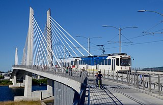
Tilikum Crossing, Bridge of the People is a cable-stayed bridge across the Willamette River in Portland, Oregon, United States. It was designed by TriMet, the Portland metropolitan area's regional transit authority, for its MAX Orange Line light rail passenger trains. The bridge also serves city buses and the Portland Streetcar, as well as bicycles, pedestrians, and emergency vehicles. Private cars and trucks are not permitted on the bridge. It is the first major bridge in the U.S. that was designed to allow access to transit vehicles, cyclists and pedestrians but not cars.

Southeast Main Street is a light rail station on the MAX Green Line in Portland, Oregon. It is the first stop southbound on the I-205 MAX branch, following the Green Line's split from the Red and Blue lines at the Gateway Transit Center.

Southeast Powell Boulevard is a light rail station on the MAX Green Line in Portland, Oregon. It is the 3rd stop southbound on the I-205 MAX branch.

Union Station/Northwest 6th & Hoyt and Union Station/Northwest 5th & Glisan are light rail stations on the MAX Green, Orange and Yellow Lines in Portland, Oregon. They are the first stops southbound on the Portland Transit Mall MAX extension. The Union Station/Northwest 6th & Hoyt Street station is served only by the Green and Yellow Lines, and the Union Station/Northwest 5th & Glisan Street station is served only by the Green and Orange Lines. Originally, from the opening of these stations in 2009 until 2015, the Yellow Line served both, but in September 2015 the then-new Orange Line replaced the Yellow Line at all southbound stations on the transit mall.

Southwest 6th & Pine and Southwest 5th & Oak stations are a pair of light rail stations on the MAX Green, Orange and Yellow Lines in Portland, Oregon. It is the 3rd stop southbound on the Portland Transit Mall extension.
Southeast Tacoma/Johnson Creek is a light rail station and park and ride for the MAX Orange Line. Service began on September 12, 2015. It is the third stop northbound on the Orange Line. The station was built for residents of the Sellwood and Ardenwald neighborhoods of Portland and Milwaukie. The station is located adjacent to Oregon Route 99E and can be directly accessed by northbound traffic and by traffic from the portion of SE Tenino Street that connects SE Tacoma to SE Johnson Creek Boulevard.

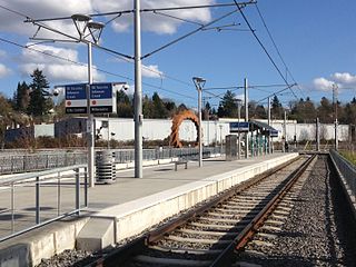
Southeast Bybee Boulevard is a light rail station in Portland, Oregon, United States, served by TriMet as part of the MAX Light Rail system. It is the 14th station southbound on the Orange Line, which runs between Portland City Center, Southeast Portland, and Milwaukie. The island platform station adjoins Union Pacific Railroad (UP) freight tracks to the east and McLoughlin Boulevard to the west. It is accessed from the Bybee Bridge, which spans over the platform and connects Portland's Sellwood-Moreland and Eastmoreland neighborhoods. Nearby destinations include Westmoreland Park, Eastmoreland Golf Course, Crystal Springs Rhododendron Garden, and Reed College.
Lincoln Street/Southwest 3rd Avenue is a light rail station on the MAX Orange Line, located at 229 Southwest Lincoln Street in Portland, Oregon.

The A and B Loop is a streetcar circle route of the Portland Streetcar system in Portland, Oregon, United States. Operated by Portland Streetcar, Inc. and TriMet, it is made up of two separate services: the 6.1-mile (9.8 km) A Loop, which runs clockwise, and the 6.6-mile (10.6 km) B Loop, which runs counterclockwise. The route travels a loop between the east and west sides of the Willamette River by crossing the Broadway Bridge in the north and Tilikum Crossing in the south.

Southeast Park Avenue is a light rail station on the MAX Orange Line located at Southeast McLoughlin Boulevard and Park Avenue in Oak Grove, an unincorporated area neighboring Milwaukie in Clackamas County, Oregon, in the United States. It is the terminus and southernmost stop on the Orange Line and has a 401-space park and ride facility.

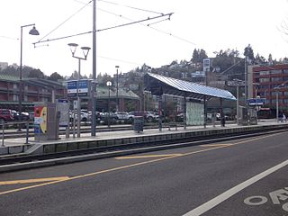
South Waterfront/South Moody, formerly South Waterfront/Southwest Moody, is a combined light rail and bus station located at 698 Southwest Porter Street in the South Waterfront neighborhood of Portland, Oregon, at the west end of the Tilikum Crossing bridge. It is serviced by the MAX Orange Line and TriMet buses. Portland Streetcar travels through it but does not service it.

Clinton Street/Southeast 12th Avenue station is a MAX Orange Line station located at 1229 Southeast Gideon Street in Portland, Oregon's Hosford-Abernethy neighborhood, in the United States. The sculpture Intersection is installed at the station.

Southeast 17th Avenue and Rhine Street is a MAX Orange Line station located at 3424 Southeast 17th Avenue in Portland, Oregon's Brooklyn neighborhood, in the United States. Along These Lines is installed at the station.


