
The Great Lakes, also called the Great Lakes of North America, are a series of large interconnected freshwater lakes in the upper mid-east region of North America that connect to the Atlantic Ocean through the Saint Lawrence River. In general, they are on or near the Canada–United States border. They are lakes Superior, Michigan, Huron, Erie, and Ontario. Hydrologically, there are only four lakes, because lakes Michigan and Huron join at the Straits of Mackinac. The Great Lakes Waterway enables travel by water between the lakes.

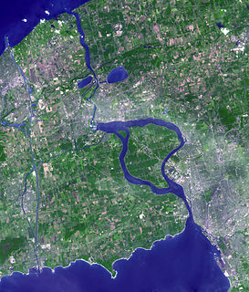
Lake Ontario is one of the five Great Lakes of North America. It is surrounded on the north, west, and southwest by the Canadian province of Ontario, and on the south and east by the American state of New York, whose water boundaries meet in the middle of the lake. Ontario, Canada's most populous province, was named for the lake.

Ontario is one of the thirteen provinces and territories of Canada. Located in Central Canada, it is Canada's most populous province, with 38.3 percent of the country's population, and is the second-largest province by total area. Ontario is Canada's fourth-largest jurisdiction in total area when the territories of the Northwest Territories and Nunavut are included. It is home to the nation's capital city, Ottawa, and the nation's most populous city, Toronto, which is also Ontario's provincial capital.
The Niagara River is a river that flows north from Lake Erie to Lake Ontario. It forms part of the border between the province of Ontario in Canada and the state of New York in the United States. There are differing theories as to the origin of the river's name. According to Iroquoian scholar Bruce Trigger, Niagara is derived from the name given to a branch of the locally residing native Neutral Confederacy, who are described as being called the Niagagarega people on several late-17th-century French maps of the area. According to George R. Stewart, it comes from the name of an Iroquois town called Ongniaahra, meaning "point of land cut in two".

The Ottawa River is a river in the Canadian provinces of Ontario and Quebec. It is named in honour of the Algonquin word 'to trade', as it was the major trade route of Eastern Canada at the time. For most of its length, it defines the border between these two provinces. It is a major tributary of the St. Lawrence River and the longest river in Quebec.
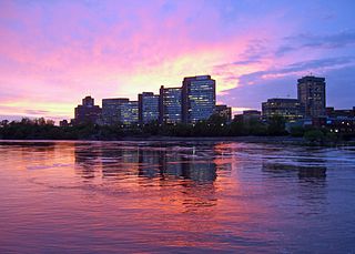
Hull is the central business district and oldest neighbourhood of the city of Gatineau, Quebec, Canada. It is located on the west bank of the Gatineau River and the north shore of the Ottawa River, directly opposite Ottawa. As part of the Canadian National Capital Region, it contains offices for over 20,000 civil servants. It is named after Kingston upon Hull in England.

The Niagara Escarpment is a long escarpment, or cuesta, in the United States and Canada that runs predominantly east–west from New York through Ontario, Michigan, Wisconsin, and Illinois. The escarpment is most famous as the cliff over which the Niagara River plunges at Niagara Falls, for which it is named.

Newmarket is a town and regional seat of the Regional Municipality of York in the Canadian province of Ontario. It is part of Greater Toronto in the Golden Horseshoe region of Southern Ontario.

Algonquin Provincial Park is a provincial park located between Georgian Bay and the Ottawa River in Ontario, Canada, mostly within the Unorganized South Part of Nipissing District. Established in 1893, it is the oldest provincial park in Canada. Additions since its creation have increased the park to its current size of about 7,653 square kilometres (2,955 sq mi). The park is contiguous with several smaller, administratively separate provincial parks that protect important rivers in the area, resulting in a larger total protected area.

The Don River is a watercourse in southern Ontario, that empties into Lake Ontario, at Toronto Harbour. Its mouth was just east of the street grid of the town of York, Upper Canada, the municipality that evolved into Toronto, Ontario. The Don is one of the major watercourses draining Toronto that have headwaters in the Oak Ridges Moraine.

Lake St. Clair is a freshwater lake that lies between the Canadian province of Ontario and the U.S. state of Michigan. It was named in 1679 by French Catholic explorers after Saint Clare of Assisi, on whose feast day they first sighted this body of water.
The Odawa, said to mean "traders", are an Indigenous American ethnic group who primarily inhabit land in the Eastern Woodlands region, commonly known as the northern United States and southern Canada. They have long had territory that crosses the current border between the two countries, and they are federally recognized as Native American tribes in the United States and have numerous recognized First Nations bands in Canada. They are one of the Anishinaabeg, related to but distinct from the Ojibwe and Potawatomi peoples.

Kenora District is a district and census division in Northwestern Ontario, Canada. The district seat is the City of Kenora.

Eastern Ontario is a secondary region of Southern Ontario in the Canadian province of Ontario which lies in a wedge-shaped area between the Ottawa River and St. Lawrence River. It shares water boundaries with Quebec to the north and New York State to the east and south, as well as a small land boundary with the Vaudreuil-Soulanges region of Quebec to the east.
The Obabika River is located in central Ontario, Canada. It is south of Lady Evelyn-Smoothwater Provincial Park and west of Lake Temagami, within Sudbury District. It flows from Obabika Lake in a south-westerly direction and drains into the Sturgeon River. The Obabika River is remote and surrounded by undeveloped wilderness.
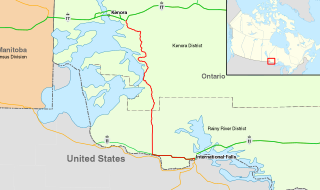
King's Highway 71, commonly referred to as Highway 71, is a provincially maintained highway in the Canadian province of Ontario. The 194-kilometre-long (121 mi) route begins at the Fort Frances–International Falls International Bridge in Fort Frances, continuing from US Highway 53 (US 53) and US 71 in Minnesota, and travels west concurrently with Highway 11 for 40 kilometres (25 mi) to Chapple. At that point, Highway 11 continues west while Highway 71 branches north and travels 154 kilometres (96 mi) to a junction with Highway 17 just east of Kenora. Highway 71 is part of the Trans-Canada Highway for its entire length, with the exception of the extremely short segment south of Highway 11 in Fort Frances.

The Niagara Frontier is part of the region known as Western New York State. The Niagara Frontier also forms the eastern part of the Great Lakes North Coast. Its southeastern boundary forms what is known as ski country, as it includes the northernmost area of the Appalachian Mountain foothills.

York South—Weston is a provincial electoral district in Toronto, Ontario, Canada, that has been represented in the Legislative Assembly of Ontario since 1999.

Fitzroy Provincial Park is a provincial park on the Ottawa River in Ontario, designated as recreational-class by Ontario Parks. White pine covers much of this park. The park has century-old trees and a stand of 300-year-old bur oaks by the Carp River. There are two campgrounds within the park, both with comfort stations, a boat launch and park store. The main campgrounds have 235 campsites, 107 with electrical service, 205 with room for trailers, and a separate area with facilities for group camping and picnicking.

The Chiniguchi Waterway Provincial Park consists of 9,368 ha (36.17 sq mi) of protected wilderness along the Chiniguchi River, Maskinonge Lake, Kukagami Lake, Wolf Lake and Matagamasi Lake in the Sudbury District of Ontario, that includes 336 hectares of Forest Reserve. The park is one of the several provincial parks located in the Sudbury area. It is managed by Ontario Parks. It contains the largest stand of old growth Red Pines.
