
The Bernese Alps are a mountain range of the Alps, located in western Switzerland. Although the name suggests that they are located in the Berner Oberland region of the canton of Bern, portions of the Bernese Alps are in the adjacent cantons of Valais, Fribourg and Vaud, the latter being usually named Fribourg Alps and Vaud Alps respectively. The highest mountain in the range, the Finsteraarhorn, is also the highest point in the canton of Bern.

The Diablerets are a huge ice-covered mountain massif of the Alps, culminating at the Sommet des Diablerets (VS) at 3,216 metres (10,551 ft) above sea level and almost straddling the border between the Swiss cantons of Vaud (VD) and Valais (VS). The northeastern part of the massif stretches also into the canton of Bern (BE).

Col du Pillon is a mountain pass in the western Swiss Alps, linking Aigle, Le Sépey and Les Diablerets in the canton of Vaud with Gstaad in the canton of Berne. The pass itself is located within the canton of Vaud, approximately one kilometre from the border with Berne. Col du Pillon is overlooked by the Diablerets and at the pass is located the lower station of the Scex Rouge cable car.

Col des Mosses is a mountain pass in the western Bernese Alps of Switzerland. The pass is located in the municipality of Ormont-Dessous in the canton of Vaud. It links Aigle, to the south in the valley of the Rhone, with Château-d'Œx, to the north in the valley of the Sarine, and is flanked to the west by the Mont d'Or and to the east by the Pic Chaussy.

The Aigle–Sépey–Diablerets railway line is a railway line in the Chablais area of Vaud and Valais in Switzerland. It was built between 1913 and 1914 by the Chemin de fer Aigle-Sépey-Diablerets (ASD) and is today owned and operated by the Transports Publics du Chablais.

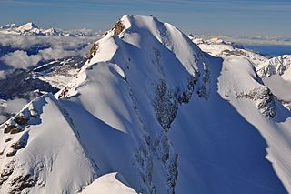
The Wildhorn is a mountain of the Alps, straddling the border between the Swiss cantons of Bern and Valais. At 3,250 metres (10,663 ft) above sea level, it is the highest summit of the Bernese Alps west of the Gemmi Pass. It forms a large glaciated massif, about 10 km wide, extending between the Sanetsch Pass and the Rawil Pass. Along with the Muverans, the Diablerets and the Wildstrubel, the Wildhorn is one of the four distinct mountain massifs of the Bernese Alps that lie west of the Gemmi Pass. The massif of the Wildhorn is at the centre between the valleys of the Saane, Simme and the Rhone (Valais). It comprises several distinct summits, including the Arpelistock, Le Sérac, the Geltenhorn, the Sex Noir, the Sex Rouge, the Schnidehorn and the Six des Eaux Froides. The main crest is between the glaciers named Tungelgletscher and Glacier du Wildhorn. South of the main summit is the almost equally high summit of Mont Pucel. The Wildhorn is surrounded by several large mountain lakes: the Lac de Sénin, the Lauenensee, the Iffigsee, the Lac de Tseuzier and the Lac des Audannes. The Tungelgletscher, on the north-east face, was measured as 1.9 km in length in 1973.

Mont Fort is a mountain of the Pennine Alps, in the Swiss canton of Valais. It lies on the range between the valleys of Nendaz and Bagnes, north of the Rosablanche. With a height of 3,328 metres (10,919 ft) above sea level, Mont Fort is the highest summit north of the Col de Louvie.

The Agassizhorn is a mountain of the Bernese Alps in Switzerland. It lies just north-west of the Finsteraarhorn, the main summit of the range. The Agassizhorn is the tripoint between the valleys of the Lower Grindelwald Glacier, the Unteraar Glacier and the Fiescher Glacier. Because the Lower Grindelwald and Unteraar glaciers drain into the Aar and hence the Rhine and North Sea, whilst the Fiescher glacier drains into the Rhone and hence the Mediterranean Sea, the Sidelhorn lies on the European continental divide.

The Scex Rouge is a mountain of the Alps, overlooking Les Diablerets in the canton of Vaud. Along with the Oldenhorn to the east, it is one of the main peaks of the Diablerets, a huge ice-covered mountain near the western end of the Bernese Alps, straddling the border between the cantons of Vaud, Valais, and Bern, and exceeding 3,000 metres (9,800 ft) above sea level. On its west side, the Scex Rouge is part of a nearly 2,000-metre-high (6,600 ft) amphitheatre of cliffs surrounding the Creux de Champ valley, south of Les Diablerets. On its southeast side, the Scex Rouge overlooks the Tsanfleuron Glacier, the largest in the massif. Administratively, the mountain is part of the municipality of Ormont-Dessus, which also includes Les Diablerets.

Le Rubli is a 2,285 metre high mountain in the western Bernese Alps, overlooking Rougemont in the canton of Vaud, near the border with the canton of Berne. Le Rubli has steep faces and its summit is relatively difficult to access. A via ferrata starts near the gondola station of the Videmanette.

Pic Chaussy is a mountain of the Vaud Alps, overlooking Les Diablerets to the south. On its northern side lies the Lac Lioson, whilst the Col des Mosses pass flanks its western side. To the east, a ridgeline connects to the peaks of the Châtillon and Le Tarent. Its summit reaches an altitude of 2,351 metres (7,713 ft).

The Tsanfleuron Glacier is a 3.5 km (2.2 mi) long glacier (2005) situated in the western Bernese Alps in the cantons of Valais and Vaud in Switzerland. In 1973 it had an area of 3.81 km2 (1.47 sq mi). It culminates at the Dôme, at approximately 3,000 metres above sea level, where it is separated from the Diablerets Glacier. The lowest point is at approx. 2,500 metres. The glacier is overlooked by the Scex Rouge and the Oldenhorn on the north, and by the Quille du Diable on the south.
Le Tarent is a mountain in the western Bernese Alps, overlooking Les Diablerets in the canton of Vaud. At 2,548 metres above sea level, it is the highest mountain of the range lying north of the Col du Pillon. The mountain, which lies near the border with the canton of Bern, is composed of several subsidiary summits, the highest being the Châtillon and La Para.

Mont Tendre is a mountain of the Jura, located between the valley of Joux and the basin of Lake Geneva in the canton of Vaud. With an elevation of 1,679 metres above sea level, it is the highest summit of the Swiss portion of the Jura Mountains and, therefore, the highest summit of Switzerland outside the Alps. It is also the most isolated mountain of the canton. It is found in the community of Montricher.

Les Diablerets is a village and ski resort located in the municipality of Ormont-Dessus in the canton of Vaud, Switzerland.

The Vanil des Artses is a mountain of the Swiss Prealps, located west of Montbovon in the canton of Fribourg. It is among a crest of peaks extending south of the Dent de Lys to the Cape au Moine (1,941m) on the border between the Cantons of Vaud and Fribourg, which in turn is just north of the Col de Jaman from Rochers de Naye, all lying on the range between Lake Geneva and the valley of Gruyère.

Le Soliat is a mountain of the Jura, overlooking Lake Neuchâtel in western Switzerland. The main summit is located within the canton of Neuchâtel. A secondary summit is located within the canton of Vaud.

The Pointe de la Plaine Morte is a mountain of the Bernese Alps, located on the border between the Swiss cantons of Bern and Valais. It overlooks the large and flat glacier named Plaine Morte Glacier, from the south-west side.
The Tête aux Chamois is a summit of the Diablerets massif, overlooking the Col du Pillon in the canton of Vaud. It is accessible by aerial tramway from the Col du Pillon and from Reusch via Oldenegg. From the summit of the Tête aux Chamois another aerial tramway leads to the summit of the Scex Rouge and the nearby Tsanfleuron Glacier.

The Quille du Diable is a peak of the Diablerets massif, located on the border of the municipalities of Conthey and Savièse in the canton of Valais. It lies on the edge of the high Tsanfleuron Glacier plateau and overlooks the valley around of Derborence 1,500 metres (4,900 ft) lower.

