Olympic (soil)

Last updated

The Olympic soil series is a type of deep, dark reddish brown moderately fine-textured soil which has developed on mafic rock such as basalt. The series covers large areas in southwestern Washington and western Oregon, and usually supports forests of Douglas-fir, red alder, western redcedar, western hemlock, and bigleaf maple. [1]

Contents

Distribution and Climate

Olympic soils are characteristic soils of the Olympic National Forest, and Olympic National Park of Western Oregon and Washington. They are found on stable summits of foothills and mountains from 200 to 2000 feet above sea level on slopes up to 65%.

These soils associated with marine-type climates that have cool dry summers and mild wet winters. Average annual precipitation is 40 to 70 inches. Mean January temperature is about 38 degrees F, mean July temperature is about 65 degrees F, average annual temperature is about 52 degrees F.

Description and Formation

Olympic soils formed in residuum and colluvium weathered from basic igneous rocks. Diagnostic horizons and features recognized in this pedon are an umbric epipedon from the surface to 13 inches and an argillic horizon from 13 to 100 inches. Base saturation is less than 35 percent to 1.8 meters.

The solum thickness ranges from 60 to more than 100 inches. The particle-size averages 15 to 25 percent course sand and 35 to 60 percent clay. Texture is clay loam, silty clay loam, silty clay, or clay. The ratio of calcium to magnesium is 2 to 4.

Average annual soil temperature at a depth of 20 inches ranges from 47 to 54 degrees F. Olympic soils are usually moist but are dry in all parts between depths of 4 and 12 inches for 45 to 60 consecutive days within the 3 months following the summer solstice.

Soil Horizons

Olympic soils have a relatively shallow and slightly cemented topsoil followed by five defining Bt horizons. A Bt horizon contains an illuvial layer of lattice clays. It forms below an eluvial horizon or at the surface of a soil that has been partially truncated. It usually has a high ratio of fine clay to total clay:

A horizon: The topsoil layer is dark brown, silty clay loam with fine subangular blocky and moderate fine granular structure. It is hard, friable, slightly sticky, and plastic, with many roots and very fine irregular pores. The layer is slightly acidic (pH 6.2) and is about 4 to 7 inches thick.

ABc horizon: The second layer is dark reddish-brown silty clay loam with a similar structure to the A horizon but with 5% concretions and moderately acid (pH 5.8).

Bt1 horizon - The third layer is dark reddish-brown silty clay loam, with moderate medium fine and very fine subangular blocky structure, 2% concretions, and moderately acid (pH 5.8).

Bt2 horizon: The fourth layer is yellowish-red silty clay with a moderate coarse subangular blocky structure that parts to medium fine subangular blocky. It has many faint and distinct clay films on faces of peds and in pores and is moderately acidic (pH 5.8).

Bt3 horizon: The fifth layer is yellowish-red clay, with moderate medium and fine subangular blocky structure, many faint and distinct clay films, and moderately acidic (pH 5.6).

Bt4 horizon: The sixth layer is yellowish-red clay, with moderate medium and fine subangular and angular blocky structure and 7% concretions. It is strongly acidic (pH 5.3).

Bt5 horizon: The seventh layer is yellowish-red rubbed, dark red, and reddish-brown clay with a moderately coarse and very coarse angular blocky structure that parts to medium and fine subangular angular blocky structure. It is very strongly acidic (pH 5.0).

Cr horizon: The final layer is strongly weathered basalt and strongly acidic (pH 4.8).

Use and Management

Olympic soils are mostly found in forest environments. Native vegetation includes douglas-fir, red alder, western hemlock, western redcedar, and bigleaf maple and an understory of salal, vine maple, western swordfern, Oregon-grape, western brackenfern, red huckleberry, trailing blackberry and Pacific trillium.

They are fertile soils are typically used for forestry and to a lesser extent grazing. The high clay content in the Bt horizon of these soils means that they are susceptible to compaction. Therefore, care must be taken when conducting these activities.

In other classification systems

Olympic soils are a series of soils in the USDA Soil Taxonomy system. They were previously classified as clayey, mixed, mesic Xeric Haplohumults. They share many similarities to Alfisols. In the Canadian System of Soil Classification, they are most similar to Luvisols due to the prolific Bt horizon.

Related Research Articles

In geotechnical engineering, soil structure describes the arrangement of the solid parts of the soil and of the pore space located between them. It is determined by how individual soil granules clump, bind together, and aggregate, resulting in the arrangement of soil pores between them. Soil has a major influence on water and air movement, biological activity, root growth and seedling emergence. There are several different types of soil structure. It is inherently a dynamic and complex system that is affected by different factors.

USDA soil taxonomy (ST) developed by the United States Department of Agriculture and the National Cooperative Soil Survey provides an elaborate classification of soil types according to several parameters and in several levels: Order, Suborder, Great Group, Subgroup, Family, and Series. The classification was originally developed by Guy Donald Smith, former director of the U.S. Department of Agriculture's soil survey investigations.

<span class="mw-page-title-main">Loam</span> Soil composed of similar proportions of sand and silt, and somewhat less clay

Loam is soil composed mostly of sand, silt, and a smaller amount of clay. By weight, its mineral composition is about 40–40–20% concentration of sand–silt–clay, respectively. These proportions can vary to a degree, however, and result in different types of loam soils: sandy loam, silty loam, clay loam, sandy clay loam, silty clay loam, and loam.

A soil horizon is a layer parallel to the soil surface whose physical, chemical and biological characteristics differ from the layers above and beneath. Horizons are defined in many cases by obvious physical features, mainly colour and texture. These may be described both in absolute terms and in terms relative to the surrounding material, i.e. 'coarser' or 'sandier' than the horizons above and below.

<span class="mw-page-title-main">World Reference Base for Soil Resources</span>

The World Reference Base for Soil Resources (WRB) is an international soil classification system for naming soils and creating legends for soil maps. The currently valid version is the fourth edition 2022. It is edited by a working group of the International Union of Soil Sciences (IUSS).

<span class="mw-page-title-main">Cecil (soil)</span>

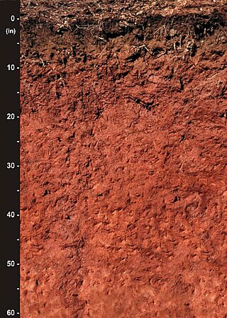
Originally mapped in Cecil County, Maryland in 1899, more than 10 million acres (40,000 km²) of the Cecil soil series are now mapped in the Piedmont region of the southeastern United States. It extends from Virginia through North Carolina, South Carolina, Georgia and Alabama, with the typic Cecil pedon actually located in Franklin County, NC.

<span class="mw-page-title-main">Brown earth</span> Soil type

Brown earth is a type of soil. Brown earths are mostly located between 35° and 55° north of the Equator. The largest expanses cover western and central Europe, large areas of western and trans-Uralian Russia, the east coast of America and eastern Asia. Here, areas of brown earth soil types are found particularly in Japan, Korea, China, eastern Australia and New Zealand. Brown earths cover 45% of the land in England and Wales. They are common in lowland areas on permeable parent material. The most common vegetation types are deciduous woodland and grassland. Due to the reasonable natural fertility of brown earths, large tracts of deciduous woodland have been cut down and the land is now used for farming. They are normally located in regions with a humid temperate climate. Rainfall totals are moderate, usually below 76 cm per year, and temperatures range from 4 °C in the winter to 18 °C in the summer. They are well-drained fertile soils with a pH of between 5.0 and 6.5.

<span class="mw-page-title-main">Soil morphology</span> Description of soil horizons

Soil morphology is the branch of soil science dedicated to the technical description of soil, particularly physical properties including texture, color, structure, and consistence. Morphological evaluations of soil are typically performed in the field on a soil profile containing multiple horizons.

Soil chemistry is the study of the chemical characteristics of soil. Soil chemistry is affected by mineral composition, organic matter and environmental factors. In the early 1870s a consulting chemist to the Royal Agricultural Society in England, named J. Thomas Way, performed many experiments on how soils exchange ions, and is considered the father of soil chemistry. Other scientists who contributed to this branch of ecology include Edmund Ruffin, and Linus Pauling.

<span class="mw-page-title-main">Fishing Creek (North Branch Susquehanna River tributary)</span> Tributary of river in Pennsylvania

Fishing Creek is a 29.98-mile (48.25 km) long tributary of the Susquehanna River in Columbia County, Pennsylvania, in the United States. It joins the Susquehanna River near the census-designated place of Rupert and the town of Bloomsburg. The watershed has an area of 385 square miles (1,000 km2).

<span class="mw-page-title-main">Santa Rosa Creek</span> River in California, United States

Santa Rosa Creek is a 22-mile-long (35 km) stream in Sonoma County, California, which rises on Hood Mountain and discharges to the Laguna de Santa Rosa by way of the Santa Rosa Flood Control Channel. This article covers both the creek and the channel.

<span class="mw-page-title-main">San Joaquin (soil)</span>

San Joaquin is an officially designated state insignia, the state soil of the U.S. state of California.

The Canadian System of Soil Classification is more closely related to the American system than any other, but they differ in several ways. The Canadian system is designed to cover only Canadian soils. The Canadian system dispenses with the sub-order hierarchical level. Solonetzic and Gleysolic soils are differentiated at the order level.

<span class="mw-page-title-main">Houdek (soil)</span>

Houdek is a type of soil composed of glacial till and decomposed organic matter. The soil series was established in 1955 in Spink County, South Dakota. It is unique to the United States, but in particular to South Dakota where it is the state soil.

In 1988, the Professional Soil Classifiers Association of Mississippi selected Natchez silt loam soil to represent the soil resources of the State. These soils exist on 171,559 acres of landscape in Mississippi.

<span class="mw-page-title-main">Coast Range (EPA ecoregion)</span> Coastal ecoregion in the Western United States

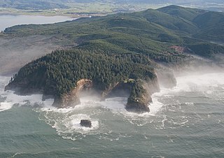
The Coast Range ecoregion is a Level III ecoregion designated by the Environmental Protection Agency (EPA) in the U.S. states of Washington, Oregon, and California. It stretches along the Pacific Coast from the tip of the Olympic Peninsula in the north to the San Francisco Bay in the south, including Grays Harbor, Willapa Bay, and the Long Beach Peninsula in Washington, the entire length of the Oregon Coast, and the Northern California Coast. Named for the Coast Range mountains, it encompasses the lower elevations of the Olympic Mountains, the Oregon Coast Range, the Californian North Coast Ranges, and surrounding lowlands.

<span class="mw-page-title-main">Ped</span> Aggregates of soil particles formed naturally

In soil science, peds are aggregates of soil particles formed as a result of pedogenic processes; this natural organization of particles forms discrete units separated by pores or voids. The term is generally used for macroscopic structural units when observing soils in the field. Soil peds should be described when the soil is dry or slightly moist, as they can be difficult to distinguish when wet.

<span class="mw-page-title-main">Western Corn Belt Plains</span>

The Western Corn Belt Plains is a Level III ecoregion designated by the Environmental Protection Agency (EPA) in seven U.S. states, though predominantly in Iowa.
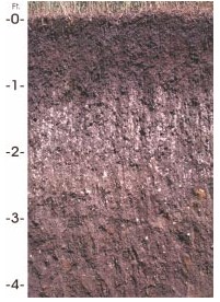
The physical properties of soil, in order of decreasing importance for ecosystem services such as crop production, are texture, structure, bulk density, porosity, consistency, temperature, colour and resistivity. Soil texture is determined by the relative proportion of the three kinds of soil mineral particles, called soil separates: sand, silt, and clay. At the next larger scale, soil structures called peds or more commonly soil aggregates are created from the soil separates when iron oxides, carbonates, clay, silica and humus, coat particles and cause them to adhere into larger, relatively stable secondary structures. Soil bulk density, when determined at standardized moisture conditions, is an estimate of soil compaction. Soil porosity consists of the void part of the soil volume and is occupied by gases or water. Soil consistency is the ability of soil materials to stick together. Soil temperature and colour are self-defining. Resistivity refers to the resistance to conduction of electric currents and affects the rate of corrosion of metal and concrete structures which are buried in soil. These properties vary through the depth of a soil profile, i.e. through soil horizons. Most of these properties determine the aeration of the soil and the ability of water to infiltrate and to be held within the soil.

References