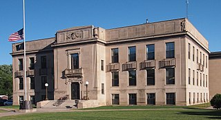
Mille Lacs County is a county in the East Central part of the U.S. state of Minnesota. As of the 2020 census, the population was 26,459. Its county seat is Milaca. The county was founded in 1857, and its boundary was expanded in 1860.
Lakeside Township is a township in Aitkin County, Minnesota, United States. The population was 463 as of the 2010 census.
Wealthwood Township is a township in Aitkin County, Minnesota, United States. The population was 268 as of the 2010 census.

Foreston is a city in Mille Lacs County, Minnesota, United States. The population was 559 at the 2020 census.

Isle is a city in Mille Lacs County, Minnesota, United States. The population was 803 at the 2020 census, up from 751 in 2010.
Isle Harbor Township is a township in Mille Lacs County, Minnesota, United States. The population was 593 at the 2010 census.
Vineland is an unincorporated community and census-designated place (CDP) in the Mille Lacs Indian Reservation portion of Mille Lacs County, Minnesota, United States. The population was 869 as of the 2020 census, down from 1,001 in 2010. Its name in the Ojibwe language is Neyaashiing, meaning "on the point of land" due to its location on Indian Point of Mille Lacs Lake. It serves as the administrative center for the Mille Lacs Band of Ojibwe.
Mille Lacs Indian Reservation is the popular name for the land-base for the Mille Lacs Band of Ojibwe in Central Minnesota, about 100 miles (160 km) north of Minneapolis-St. Paul. The contemporary Mille Lacs Band reservation has significant land holdings in Mille Lacs, Pine, Aitkin and Crow Wing counties, as well as other land holdings in Kanabec, Morrison, and Otter Tail Counties. Mille Lacs Indian Reservation is also the name of a formal Indian reservation established in 1855. It is one of the two formal reservations on which the contemporary Mille Lacs Band retains land holdings. The contemporary Mille Lacs band includes several aboriginal Ojibwe bands and villages, whose members reside in communities throughout central Minnesota.
Lake Lena is an unincorporated community and Native American village in Ogema Township, Pine County, Minnesota, United States, located along the Lower Tamarack River. It currently is the administrative center for the Mille Lacs Indian Reservation, District III.
Sandy Lake is an unincorporated community Native American village located in Turner Township, Aitkin County, Minnesota, United States. Its name in the Ojibwe language is Gaa-mitaawangaagamaag, meaning "Place of the Sandy-shored Lake". The village is administrative center for the Sandy Lake Band of Mississippi Chippewa, though the administration of the Mille Lacs Indian Reservation, District II, is located in the nearby East Lake.
Glen is an unincorporated community and business district in Aitkin County, Minnesota, United States. The community is located southeast of the city of Aitkin at the junction of State Highway 47, Aitkin County Road 12, and 280th Street.
Malmo is an unincorporated community and business district in Aitkin County, Minnesota, United States. The community is located on the northeast corner of Mille Lacs Lake at the junction of State Highway 18, State Highway 47, and Aitkin County Road 2.
Woodland is an unincorporated community in Ford Township, Kanabec County, Minnesota, United States.
Glory is an unincorporated community in Aitkin County, Minnesota, United States. The community is located along 360th Avenue near Aitkin County Road 12. 280th Street is also in the immediate area. Glory is located within Nordland Township and Wealthwood Township. Nearby places include Aitkin and Glen. State Highway 47 and Aitkin County Road 28 are both nearby. Glory is four miles north of Mille Lacs Lake.
Estes Brook is an unincorporated community in Mille Lacs County, Minnesota, United States. The community is located near the junction of Mille Lacs County Road 7 and 70th Street. County Roads 12 and 13 are also in the immediate area.
Cove is an unincorporated community in South Harbor Township, Mille Lacs County, Minnesota, United States, near Onamia. The community is located along State Highway 27 near 100th Avenue.
Bayview is an unincorporated community in South Harbor Township, Mille Lacs County, Minnesota, United States. The community is located along State Highway 27 at 92nd Avenue near Onamia and Isle.
Wealthwood is an unincorporated community in Wealthwood Township, Aitkin County, Minnesota, United States, along the north shore of Mille Lacs Lake. The community is located along State Highway 18 near the junction with Aitkin County Road 51, 385th Avenue. Nearby places include Garrison, Malmo, Glen, and Aitkin.
Nichols is an unincorporated community in Hazelton Township, Aitkin County, Minnesota, United States, along the north shore of Mille Lacs Lake. The community is located along U.S. 169 / State Highway 18 (co-signed) near 450th Avenue. Nearby places include Garrison, Malmo, Cutler, and Aitkin.
The Rum River State Forest is a state forest located in Kanabec, Mille Lacs and Morrison counties in central Minnesota. The forest is nearby the city of Onamia and is along the Rum River, just downstream (south) of Mille Lacs Lake. The forest is managed by the Minnesota Department of Natural Resources. The forest is home to many Northern hardwoods such as maple, oak, ash, elm and basswood that occupy most of the upland areas while tamarack and black spruce are found in lowland and marshy areas.


