
U.S. Highway 26 is an east–west United States Numbered Highway that runs from Seaside, Oregon, to Ogallala, Nebraska. When the U.S. Numbered Highway System was first defined, it was limited to Nebraska and Wyoming; by the 1950s, it continued into Idaho and Oregon. The highway's eastern terminus is in Ogallala at an intersection with Interstate 80 (I-80). Its western terminus is south of Seaside at an intersection with US 101. Prior to 2004, the route's last 20 miles (32 km) were cosigned with US 101 from the highways' junction south of Seaside north to Astoria where its intersection with US 30 was also US 30's western terminus. Long segments of the highway follow the historic Oregon Trail. At its peak, immediately before the establishment of the Interstate Highway System, US 26 was 1,557 miles (2,506 km) in length and terminated in Astoria.

The McKenzie River is a 90-mile (145 km) tributary of the Willamette River in western Oregon in the United States. It drains part of the Cascade Range east of Eugene and flows westward into the southernmost end of the Willamette Valley. It is named for Donald McKenzie, a Scottish Canadian fur trader who explored parts of the Pacific Northwest for the Pacific Fur Company in the early 19th century. As of the 21st century, six large dams have been built on the McKenzie and its tributaries.

U.S. Route 28 (US 28) was an east–west United States Numbered Highway that was located completely in the U.S. state of Oregon. It connected US 99 in Eugene with US 30 in Ontario. It existed from 1926 to 1952.

Oregon OR 126 (OR 126) is a 204.63-mile-long (329.32 km) state highway that connects coastal, western, and central parts of the U.S. state of Oregon. A short freeway section of OR 126 in Eugene and Springfield is concurrent with Interstate 105 (I-105).

The McKenzie Pass–Santiam Pass Scenic Byway is an 82-mile-long (132 km) National Scenic Byway in the U.S. state of Oregon. The route is a loop designed to provide a tour of the high Cascade Range northwest of Bend, passing over both McKenzie Pass and Santiam Pass.
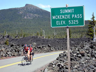
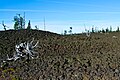
McKenzie Pass, elevation 5,325 feet (1,623 m), is a mountain pass in the Cascade Range in central Oregon in the United States.

Oregon Route 99E Business is a business route through Salem, Oregon for Oregon Route 99E, which bypasses downtown via Interstate 5 (I-5). A portion of this highway was originally planned to be a freeway, signed as Interstate 305; however the proposed freeway was cancelled after community opposition.

Oregon Route 214 is an Oregon state highway which runs from the city of Woodburn, southeast into Silver Falls State Park in the Cascade foothills, and then loops back west towards Salem. The northern segment of the highway is known as the Hillsboro-Silverton Highway No. 140, a designation which continues north on OR 219, and the southern segment is known as the Silver Creek Falls Highway No. 163.
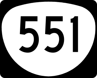
Oregon Route 551 is an Oregon state highway that runs between the cities of Wilsonville and Hubbard. It is known as the Wilsonville-Hubbard Highway No. 51 and is also called the "Hubbard Cutoff." It is 5.94 miles (9.56 km) long, and is a two-lane limited access highway for its entire length.

Oregon Route 22 is an Oregon state highway that runs between the Oregon Coast community of Hebo, to a junction with U.S. Route 20 near Santiam Pass in the Cascade Mountains. OR 22 traverses several highways of the Oregon state highway system, including the Three Rivers Highway No. 32, part of the Salmon River Highway No. 39, the Willamina–Salem Highway No. 30, part of the Salem Highway No. 72, and the North Santiam Highway No. 162.
Oregon Route 99E is an Oregon state highway that runs between Junction City, Oregon and an interchange with I-5 just south of the Oregon/Washington border, in Portland. It, along with OR 99W, makes up a split of OR 99 in the northern part of the state. This split existed when the route was U.S. Route 99, when the two branches were U.S. 99W and U.S. 99E.
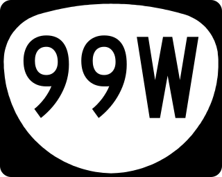
Oregon Route 99W is a state-numbered route in Oregon, United States, that runs from OR 99 and OR 99E in Junction City north to I-5 in southwestern Portland. Some signage continues it north to US 26 near downtown, but most signage agrees with the Oregon Department of Transportation's (ODOT) description, ending it at I-5. OR 99W is known by ODOT as the Pacific Highway West No. 1W ; that highway continues north through downtown to the Pacific Highway No. 1 (I-5) in northern Portland, as well as south on OR 99 to the Pacific Highway (I-5) in Eugene.
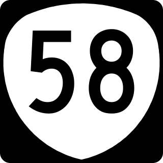
Oregon Route 58, also known as the Willamette Highway No. 18, is a state highway in the U.S. state of Oregon. The route, signed east–west, runs in a southeast–northwest direction, connecting U.S. Route 97 north of Chemult with Interstate 5 south of Eugene. It links the Willamette Valley and Central Oregon, crossing the Cascade Range at Willamette Pass. OR 58 is generally a modern two-lane highway with a speed limit of 55 mph (88 km/h), built through the Willamette National Forest in the 1930s.

Montana State Highway 1 (MT 1) is a state highway in Deer Lodge and Granite counties in southwestern Montana, United States, extending west and north from the Anaconda I-90 Junction to Drummond. Both the beginning and endpoints of the road are on Interstate 90. It is known as the Pintler Scenic Loop and provides access to the community of Philipsburg and the communities near Georgetown Lake.
New York State Route 86 (NY 86) is a 39.11-mile (62.94 km) long state highway located within Adirondack Park in northern New York, in the United States, linking Franklin County to Essex County. The western terminus of the route is at NY 30 in the hamlet of Paul Smiths. The eastern terminus is at NY 9N in Jay. Although largely a two-lane road, NY 86 is one of only two east–west highways in the High Peaks area of the Adirondack Park, providing a major link between hamlets and tourist destinations.

New York State Route 186 (NY 186) is a short east–west state highway in northern New York in the United States. The highway is located entirely within the town of Harrietstown in the southwest part of Franklin County. The western terminus is at NY 30 and the eastern terminus is at NY 86. NY 186 lies south of, and serves, the Adirondack Regional Airport. The current alignment of NY 186 was designated in 1989 to follow a former routing of NY 86.
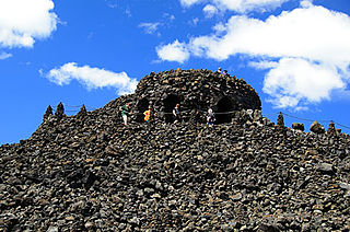
Dee Wright Observatory is an observation structure at the summit of McKenzie Pass in the Cascade Mountains of Oregon. The structure is an open shelter constructed with lava stone. It is located in the midst of a large lava flow, and offers an exceptional view of numerous Cascade peaks.

U.S. Route 62 (US 62) in Kentucky runs for a total of 391.207 miles (629.587 km) across 20 counties in western, north-central, and northeastern Kentucky. It enters the state by crossing the Ohio River near Wickliffe, then begins heading eastward at Bardwell, and traversing several cities and towns across the state up to Maysville, where it crosses the Ohio River a second time to enter the state of Ohio.

Several special routes of U.S. Route 40 exist. In order from west to east they are as follows.

Lost Creek is an unusual 3-mile (5 km) tributary of the McKenzie River in Lane County, in the U.S. state of Oregon. It is the lower section of a hydrogeological system, a losing stream, that begins at the base of Collier Glacier in the Cascade Range. This lower section rises from a spring complex north of Oregon Route 242 in the Cascade Range and flows generally northwest to meet the river near Belknap Springs. This is near the intersection of Route 242 with Oregon Route 126 and about 74 miles (119 km) upstream of the McKenzie's confluence with the Willamette River.


