Oreum (Korean : 오름; Hanja : 岳) refers to the around 360 small rising extinct volcanoes on Jeju Island, in Jeju Province, South Korea. [1] [2] They are commonly described as cinder cones or parasitic cones, and are often inside larger volcanic craters. [1]
The word oreum comes from the Jeju language. It refers to small mountains. [2] "Oreum" itself originates from the word "climb" (오르다). [3] The word is now considered to refer to Jeju's numerous small parasitic cones (측화산;側火山; also 기생화산;寄生火山). [1]
Around 360 oreum are distributed throughout Jeju. Their formation and preservation are due in part to the high permeability of the volcanic rock. [1]
Magma erupting under pressure can solidify into scoria, which may fall and pile up around a crater to form circular and elliptical scoria cones and cinder cones. These are popularly known as oreum in Jeju Island. There are about 360 such oreum. Oreum are classified as cinder cones, lava domes, fault blocks, or cryptodomes. [4]
Oreum are considered culturally and symbolically important to Jeju. They have traditionally been associated with folk religion and ancestral worship rituals. Oreum also serve as sites of settlements (particularly at their bases), agriculture, and defense. [1]
Geomunoreum is located between Jeju City and Seogwipo, on the eastern side of the island. This oreum is considered geologically interesting because of its significant lava tube system. In June 2007, this system was made a UNESCO World Natural Heritage Site, as part of the item Jeju Volcanic Island and Lava Tubes, because of its high academic and natural heritage value. [5] [6] Tourists are able to enter some of the lava tube system, as well as hike on a trail on the oreum. [7] [6]
Yongnuni Oreum is 247.8 m (813 ft) tall oreum in Gujwa, Jeju City. It is likely named for, and is said to resemble a Chinese dragon lying down. [8] The oreum is considered beautiful, with scenic views of the east coast of Jeju, including of the mountain Seongsan Ilchulbong and the island Udo. Its gentle incline makes it a popular hiking destination for families. [9] [10] [11]
Geum Oreum, alternatively Geomeun Oreum, [12] is located in Hallim, Jeju City. It is 427 m (1,401 ft) above sea level at its highest point. It is on privately-owned land, [13] and offers views of Hallasan and Sanbangsan, as well as paragliding from the top. [14] [15] [16] People can hike up to the top, where there is a marshy area inside a caldera. [17] [18]
Saebyeol Oreum is located in Bongseong-ri, Aewol-eup, Jeju. Saebyeol Oreum was also called the Saebel Oreum or Saebil Oreum. It was written as Hyobyeolak (曉別岳) in the geography book Sinjeungdonggukyeojiseungram , Hyoseongak (曉星岳) in the text T'amnajidomitchidobyŏngsŏ and Sinseongak (新星岳) in the text Jejuguyneupji (제주군읍지). There is a view that Saebel and Saebil are words in the Jeju language meaning "stars" but this is uncertain. At the southern peak, there are ridges in the southwest, northwest, and northeast directions and there are 5 dagger-shaped mountaintops that look like a star. And Saebyeol Oreum was the place where Goryeo [Korean) military under General Choi Young suppressed the Mongolian military. [19]
Darangswi Oreum is located in Sehwa-ri, Gujwa-eup, Jeju. Although it is only 382 meters above sea level, it has all of the characteristics of a volcanic terrain and is called a 'queen of oreum. [20] Darangswi (다랑쉬) is the dialect of Jeju which means the Moon. It is named Darangswi because the crater of mountain peaks looks like a full moon. There is a large, deep funnel-shaped circular crater in the mountain area. The outer circumference of this crater is about 1,500 m. It forms a long ellipse from south to north, the north is relatively flat. The depth of the crater is 115 m, which is the same as Baengrokdam on Hallasan Mountain. Most oreum are asymmetrically inclined, whereas Darangswi Oreum is arranged with concentric contour lines. [21] There is a village of Darangswi, which was abandoned due to the Jeju Uprising. In 1992, eleven of the remains of the victims were unearthed at the Darangswi cave.
Ttarabi Oreum is located in Gasi-ri, Pyoseon-myeon, Seogwipo. One of the biggest features there is 3 craters. Several large and small peaks are connected with a smooth ridge. On the horseshoe-shaped foot of the mountain, there are debris slide layers as Dunji Oreum in Gujwa-eup. It is said that it is considered to belong to a recent volcano erupted because of the debris slide. [22] It is said that the name, Ttarabi (따라비) comes from the name Ttangharabeoji (땅할아버지), which looks like a family with nearby oreum. Ttangharabeoji means grandfather for ground in English. Ttarabi Oreum is a typical autumn oreum. As well as the foot of the oreum, the surrounding mountain is a silver grass field. Back then, horses were released and raised in the great grassland. [23]
Classification | Sum | Horseshoe-type | Cone-type | Circle-type | Hybrid-type |
---|---|---|---|---|---|
Sum | 368 | 174 | 102 | 53 | 39 |
Jeju City | 59 | 29 | 21 | 6 | 3 |
Seogwipo | 37 | 8 | 20 | 6 | 3 |
Hallim-eup | 16 | 9 | 2 | 2 | 3 |
Aewol-eup | 50 | 25 | 17 | 2 | 6 |
Gujwa-eup | 40 | 26 | 1 | 7 | 6 |
Jocheon-eup | 30 | 17 | 2 | 7 | 4 |
Hangyeong-myeon | 13 | 5 | 2 | 3 | 3 |
Udo-myeon | 2 | - | 1 | - | 1 |
Daejeong-eup | 8 | 3 | 3 | 1 | 1 |
Namwon-eup | 29 | 12 | 11 | 6 | - |
Seongsan-eup | 22 | 9 | 6 | 5 | 2 |
Andeok-myeon | 31 | 13 | 10 | 3 | 5 |
Pyoseon-myeon | 31 | 18 | 6 | 5 | 2 |
This is a list of oreum on Jeju. [25] There are reportedly 368 oreum, of which 63% are privately-owned. [26]
This is a list of 51 oreum in Jeju City (제주시)
This is a list of 31 oreum in Seogwipo (서귀포시)
This is a list of 32 oreum in Aewol-eup (애월읍)
This is a list of 16 oreum in Hallim-eup (한림읍)
This is a list of 8 oreum in Daejeong-eup (대정읍)
This is a list of 18 oreum in Seongsan-eup (성산읍)
This is a list of 33 oreum in Gujwa-eup (구좌읍)
This is a list of 25 oreum in Jocheon-eup (조천읍)
This is a list of 23 oreum in Namwon-eup (남원읍)
This is a list of 30 oreum in Andeok-myeon (안덕면)
This is a list of 26 oreum in Pyoseon-myeon (표선면)
This is a list of 12 oreum in Hangyeong-myeon (한경면)
This is a list of 1 oreum in Udo-myeon (우도면)
Jeju Province, officially Jeju Special Self-Governing Province, is the southernmost province of South Korea, consisting of eight inhabited and 55 uninhabited islands, including Mara Island, Udo Island, the Chuja Archipelago, and the country's largest island, Jeju Island. The province is located in the Korea Strait, with the Korean Peninsula to the northwest, Japan to the east, and China to the west. The province has two cities: the capital Jeju City, on the northern half of the island and Seogwipo, on the southern half of the island. The island is home to the shield volcano Hallasan, the highest point in South Korea. Jeju and Korean are the official languages of the province, and the vast majority of residents are bilingual.
Hallasan (Korean: 한라산) is a shield volcano on Jeju Island in South Korea. Its summit, at 1,947 m (6,388 ft), is the highest point in the country. The area around the mountain is a designated national park, named Hallasan National Park. Hallasan is commonly considered to be one of the three main mountains of South Korea, along with Jirisan and Seoraksan.
Jeju City is the capital of the Jeju Province in South Korea and the largest city on Jeju Island. The city is served by Jeju International Airport.
Seogwipo is the second-largest city on Jeju Island, settled on a rocky volcanic coastline in the southern part of Jeju Province, South Korea. In July 2006, Seogwipo's boundaries were expanded to include the entire southern half of Jeju island. A UNESCO World Heritage Site and 2002 FIFA World Cup host, it had a population of 192,566 as of the end of February, 2024.
A parasitic cone is the cone-shaped accumulation of volcanic material not part of the central vent of a volcano. It forms from eruptions from fractures on the flank of the volcano. These fractures occur because the flank of the volcano is unstable. Eventually, the fractures reach the magma chamber and generate eruptions called flank eruptions, which, in turn, produce a parasitic cone.
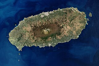
Jeju Island is South Korea's largest island, covering an area of 1,833.2 km2 (707.8 sq mi), which is 1.83% of the total area of the country. Alongside outlying islands, it is part of Jeju Province and makes up the majority of the province.
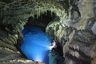
The Jeju Volcanic Island and Lava Tubes is a World Heritage Site in South Korea. It was inscribed as one of the UNESCO World Heritage Sites in 2007 because of the Geomunoreum Lava Tube System and the exhibition of diverse and accessible volcanic features which are considered to demonstrate a distinctive and valuable contribution to the understanding of global volcanism.
Gotjawal (Korean: 곶자왈) is a Jeju-language term for a dense and wild forest. The term is now used to describe the forest biome of Jeju Island, in Jeju Province, South Korea.
Jeju Olle Trail (Korean: 제주올레길) is a long-distance footpath on Jeju Island, in Jeju Province, South Korea. The trail consists of 21 connected numbered main routes, 6 sub-routes, and a short spur that connects to Jeju International Airport. On average, the routes are 16 km in length and total 437 km. They mainly follow Jeju's coastline and around its outlying islands, passing beaches, fishing villages, indigenous forest, tourist destinations, and urban centers. The exact length and locations change over time as trails are modified or re-routed. Jeju Olle Trail was envisioned and developed by former journalist Suh Myung-sook.
Udo, also known as U Island and sometimes Soseom (소섬), is an island in Jeju Province, South Korea. It is 2.8 km (1.7 mi) off the coast of Jeju Island, and is the second-largest island in the province.
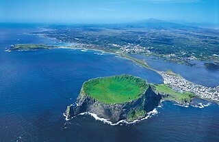
Seongsan Ilchulbong (Korean: 성산일출봉), also called Sunrise Peak, is a volcano on eastern Jeju Island, in Seongsan-ri, Seogwipo, Jeju Province, South Korea. It is 182 meters high and has a volcanic crater at the top.
Seolmundae Halmang (Korean: 설문대할망) is a creator goddess in the mythology of Jeju Island. She features prominently in Jeju shamanism. There are a diverse array of stories surrounding her, with many describing her creating the various geological features of Jeju Island. Her stories are said to have elements of both mythology and tall tales; legends attribute both divine and human properties to her, including mortality.
Gujwa is a town located in Jeju City, Jeju Province, South Korea.
Hallim is a town located in Jeju City, Jeju Province, South Korea. The population of Hallim is 20,910 people and 10,737 households.
Sanbangsan is a volcano located on the southwest coast of Jeju Island, in Andeok-myeon, Seogwipo, Jeju Province, South Korea. It is a trachytic lava dome that is 395 m (1,296 ft) tall.
Geomunoreum, alternatively Geomeunoreum (검은오름), is an oreum around Jocheon and Gujwa in Jeju City, Jeju Province, South Korea.
Yongnuni Oreum is an oreum in Gujwa, Jeju City, Jeju Province, South Korea.
Gama Oreum is an oreum in Cheongsu-ri, Hangyeong-myeon, Jeju City, Jeju Province, South Korea.
Geomeun Oreum, popularly called Geum Oreum and alternately called Geumak, is an oreum in Hallim, Jeju City, Jeju Province, South Korea.
Saebyeol Oreum is an oreum in Aewol, Jeju City, Jeju Province, South Korea. It has an area of 0.522 km2 (0.202 sq mi), circumference of 2,713 m (8,901 ft), and height of 519.3 m (1,704 ft).