Orlinda, Tennessee

Last updated

Orlinda, Tennessee
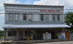
Orlinda Tennessee General Store 07272013.jpg
Orlinda General Store in Orlinda
Motto: 
"The Sunniest Spot in Tennessee"
Robertson County Tennessee Incorporated and Unincorporated areas Orlinda Highlighted 4756020.svg
Location of Orlinda in Robertson County, Tennessee.
Coordinates: 36°36′03″N86°43′00″W / 36.6008769°N 86.7166630°W / 36.6008769; -86.7166630
Country United States
State Tennessee
County Robertson
Government
  MayorTabitha Swearingen
  City ManagerKevin Breeding
Area
[1]
  Total6.59 sq mi (17.06 km2)
  Land6.59 sq mi (17.06 km2)
  Water0.00 sq mi (0.00 km2)
Elevation
[2]
719 ft (219 m)
Population
 (2020) [3]
  Total947
  Density143.72/sq mi (55.49/km2)
Time zone UTC-6 (Central (CST))
  Summer (DST) UTC-5 (CDT)
ZIP code
37141
Area code 615
FIPS code 47-56020 [4]
GNIS feature ID1296487 [2]

Orlinda is a city in Robertson County, Tennessee. The population was 947 at the 2020 census, the community became a city in February 2001. [5] The City of Orlinda conducted its own, independent census 2007. The results of that census were submitted to the State of Tennessee, which conducted a review and random sample before officially certifying the results, which it did in May 2007.

Contents

The Mayor of Orlinda is Tabitha Swearingen and the City Manager is Kevin Breeding.

History

Orlinda was incorporated in 1965, and was originally called Crockers Crossroads until they had to change the name due to the area's proximity to Tuckers Crossroads, Tennessee. The name Centervile was proposed, but denied as a Centerville, Tennessee already existed, so Orlinda was proposed as no other community in the United States used that name. [6]

In October 2000, the Orlinda City Hall and Post Office opened at its present-day location on Highway 52. Prior to this, the City Hall was located at the former Bank of Orlinda building, which was built in 1909, and is now the city's public library, which opened in 2003. [7]

On the morning of March 15, 2019, a bridge collapsed along Highland Road that went over the Red River, no one was injured during the collapse. [8] On October 22, 2019, Orlinda City Manager Kevin Breeding's house caught on fire while he was asleep, Breeding was not harmed in the fire. [9]

Education

Orlinda students attend East Robertson Elementary School (Pre-K–5th) and East Robertson High School (6-12), both schools are located in Cross Plains

Geography

Orlinda Baptist Church - Orlinda, Tennessee Orlinda Baptist Church - Orlinda Tennessee 07272013.jpg
Orlinda Baptist Church - Orlinda, Tennessee

According to the United States Census Bureau, the town had a total area of 6.7 square miles (17 km2), all land.

Demographics

Historical population
CensusPop.Note
1970 347
1980 38210.1%
1990 46922.8%
2000 59426.7%
2010 85944.6%
2020 94710.2%
Sources: [10] [3]

2020 census

Orlinda racial composition [11]
RaceNumberPercentage
White (non-Hispanic)82887.43%
Black or African American (non-Hispanic)343.59%
Other/Mixed 505.28%
Hispanic or Latino 353.7%

As of the 2020 United States census, there were 947 people, 345 households, and 256 families residing in the city.

2000 census

As of the census [4] of 2000, there were 594 people, 235 households, and 176 families residing in the town. The population density was 89.1 inhabitants per square mile (34.4/km2). There were 264 housing units at an average density of 39.6 per square mile (15.3/km2). The racial makeup of the town was 95.29% White, 4.04% African American, 0.17% Asian, and 0.51% from two or more races. Hispanic or Latino of any race were 0.67% of the population.

There were 235 households, out of which 32.8% had children under the age of 18 living with them, 64.3% were married couples living together, 8.1% had a female householder with no husband present, and 24.7% were non-families. 23.4% of all households were made up of individuals, and 13.2% had someone living alone who was 65 years of age or older. The average household size was 2.53 and the average family size was 2.98.

In the town the population was spread out, with 23.6% under the age of 18, 8.9% from 18 to 24, 26.3% from 25 to 44, 26.1% from 45 to 64, and 15.2% who were 65 years of age or older. The median age was 38 years. For every 100 females, there were 92.9 males. For every 100 females age 18 and over, there were 93.2 males.

The median income for a household in the town was $45,000, and the median income for a family was $53,625. Males had a median income of $33,750 versus $20,341 for females. The per capita income for the town was $16,058. About 6.2% of families and 9.7% of the population were below the poverty line, including 13.5% of those under age 18 and 17.6% of those age 65 or over.

Related Research Articles

<span class="mw-page-title-main">Robertson County, Tennessee</span> County in Tennessee, United States

Robertson County is a county located on the central northern border of Tennessee in the United States. As of the 2020 United States Census, the population was 72,803 people. Its county seat is Springfield. The county was named for James Robertson, an explorer, founder of Nashville, and a state senator, who was often called the "Father of Middle Tennessee." Robertson County is a component of the Nashville-Davidson–Murfreesboro–Franklin, TN Metropolitan Statistical Area.

<span class="mw-page-title-main">Cheatham County, Tennessee</span> County in Tennessee, United States

Cheatham County is a county located in the U.S. state of Tennessee. As of the 2020 census, the population was 41,072. Its county seat is Ashland City. Cheatham County is located in Middle Tennessee, and is part of the Nashville-Davidson–Murfreesboro–Franklin, TN Metropolitan Statistical Area.

<span class="mw-page-title-main">Huntingdon, Tennessee</span> Town in Tennessee, United States

Huntingdon is a town in Carroll County, Tennessee, United States. The population was 4,439 at the 2020 census and 3,985 in 2010. It is the county seat of Carroll County.

<span class="mw-page-title-main">Pleasant View, Tennessee</span> City in Tennessee, United States

Pleasant View is a city on the northern border of Cheatham County. Located in Middle Tennessee, it is part of the Nashville-Davidson–Murfreesboro–Franklin, TN Metropolitan Statistical Area. As of the 2020 census, the city's population was 4,807.

<span class="mw-page-title-main">Oak Hill, Tennessee</span> City in Tennessee, United States

Oak Hill is a city in Davidson County, Tennessee. The population was 4,529 at the 2010 census. The Tennessee Governor's Mansion is located in the city. Although the city is administered under the Metropolitan Government of Nashville and Davidson County, it retains its own municipal government.

<span class="mw-page-title-main">Charlotte, Tennessee</span> Town in Tennessee, United States

Charlotte is a town in Dickson County, Tennessee, United States. The population was 1,656 at the 2020 census. It is the county seat of Dickson County. This town is part of the Nashville metropolitan area.

<span class="mw-page-title-main">Parkers Crossroads, Tennessee</span> City in Tennessee, United States

Parkers Crossroads is a city in Henderson County, Tennessee, United States. The population was 330 as of the 2010 census, up from 241 at the 2000 census.

<span class="mw-page-title-main">Cedar Hill, Tennessee</span> City in Tennessee, United States

Cedar Hill is a city in Robertson County, Tennessee, United States. As of the 2020 census, the population was 301.

<span class="mw-page-title-main">Coopertown, Tennessee</span> Town in Tennessee, United States

Coopertown is a town in southern Robertson County. It is a self-described "bedroom community." Located in Middle Tennessee, Coopertown is part of the Nashville-Davidson–Murfreesboro–Franklin, TN Metropolitan Statistical Area. As of the 2020 census, the population was 4,480.

<span class="mw-page-title-main">Cross Plains, Tennessee</span> City in Tennessee, United States

Cross Plains is a city in Robertson County, Tennessee. The city's population was 1,789 at the 2020 census. Cross Plains was the first area of Robertson County that was settled by European settlers, with the arrival of Thomas Kilgore in 1778.

<span class="mw-page-title-main">Springfield, Tennessee</span> City in Tennessee, United States

Springfield is the county seat of Robertson County, Tennessee, United States. It is located in Middle Tennessee near the northern border of the state. As of the 2020 census, the city's population was 18,782.

<span class="mw-page-title-main">Winfield, Tennessee</span> Town in Tennessee, United States

Winfield is a town in Scott County, Tennessee, United States. Originally named Chitwood in the late 18th century for Revolutionary War hero Captain James Chitwood after his family settled the area extensively, the name was changed following the Civil War due to the family's mixed allegiances. The name Winfield was picked in honor of US army general Winfield Scott. The population was 947 at the 2020 census and 967 at the 2010 census.

<span class="mw-page-title-main">Portland, Tennessee</span> City in Tennessee, United States

Portland is a city in Sumner and Robertson counties in Tennessee. The population was 11,486 in 2010 according estimates by the U.S. census bureau and in 2020 the population was 13,156. Portland is a part of the Nashville Metropolitan Statistical Area.

<span class="mw-page-title-main">Narrows, Virginia</span> Town in Virginia, United States

Narrows, named for the narrowing of the New River that flows through the town, is a town in Giles County, Virginia, United States. The population was 2,029 at the 2010 census, a decline of 3.9% from the 2000 count of 2,111. It is part of the Blacksburg–Christiansburg Metropolitan Statistical Area.

<span class="mw-page-title-main">Surry, Virginia</span> Town in Virginia, United States

Surry is an incorporated town in Surry County, Virginia, United States. The population was 244 at the 2010 census. It is the county seat of Surry County. Its name is derived from the historic county of Surrey in England.

<span class="mw-page-title-main">McKenzie, Tennessee</span> City in Tennessee, United States

McKenzie is a city at the tripoint of Carroll, Henry, and Weakley counties in Tennessee, United States. The population was 5,310 at the 2010 census.

<span class="mw-page-title-main">Ridgetop, Tennessee</span> City in Tennessee, United States

Ridgetop is a city in Davidson and Robertson counties in the U.S. state of Tennessee. The population was 1,874 at the 2010 census.

Millersville is a city in Robertson and Sumner counties, Tennessee. The population was 5,308 at the 2000 census and 6,440 in 2010.

<span class="mw-page-title-main">White House, Tennessee</span> City in Tennessee, United States

White House is a city in Robertson and Sumner counties in the United States state of Tennessee. The population was listed as 12,982 in the 2020 census. It is approximately twenty-two miles north of downtown Nashville.

Hammond is a town in St. Croix County, Wisconsin, United States. The population was 947 at the 2000 census. The Village of Hammond is located within the town.

References

  1. "ArcGIS REST Services Directory". United States Census Bureau. Retrieved October 15, 2022.
  2. 1 2 U.S. Geological Survey Geographic Names Information System: Orlinda, Tennessee
  3. 1 2 "Census Population API". United States Census Bureau. Retrieved October 15, 2022.
  4. 1 2 "U.S. Census website". United States Census Bureau . Retrieved January 31, 2008.
  5. Population Estimates Boundary Changes, United States Census Bureau, July 1, 2007. Accessed 2008-11-06.
  6. Miller, Larry L. (2001). Tennessee Place-names. Indiana University Press. p. 11. ISBN   0-253-21478-5.
  7. "Past & Present Converge At Orlinda's Public Library Grand Reopening". Smokey Barn News. December 1, 2015. Retrieved November 21, 2019.
  8. "Robertson County road closed after bridge collapse". WSMV. March 15, 2019. Retrieved November 18, 2019.
  9. "Orlinda City Manager And Dog Escape Home Fire". Smokey Barn News. October 23, 2019. Retrieved November 18, 2019.
  10. "Census of Population and Housing: Decennial Censuses". United States Census Bureau . Retrieved March 4, 2012.
  11. "Explore Census Data". data.census.gov. Retrieved December 26, 2021.