
The Lane Cove National Park is a protected national park that is located within metropolitan Sydney, in New South Wales, Australia. The 372-hectare (920-acre) national park is situated about 10 kilometres (6.2 mi) north-west of the Sydney central business district and features various vegetation types, such as, wet and dry sclerophyll forest, heathland, mangroves and tidal flats. The park consists of land near the banks of the Lane Cove River, which flows generally south-east into Sydney Harbour. It also extends to the outskirts of Pennant Hills and Wahroonga at its northern boundaries.
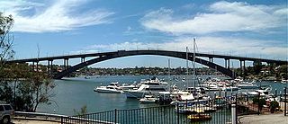
Gladesville Bridge is a heritage-listed concrete arch road bridge that carries Victoria Road over the Parramatta River, linking the Sydney suburbs of Huntleys Point and Drummoyne, in the local government areas of Canada Bay and Hunter's Hill, in New South Wales, Australia. Despite its name, the bridge is not in Gladesville.

The Parramatta River is an intermediate tide-dominated, drowned valley estuary located in Sydney, New South Wales, Australia. With an average depth of 5.1 metres (17 ft), the Parramatta River is the main tributary of Sydney Harbour, a branch of Port Jackson. Secondary tributaries include the smaller Lane Cove and Duck rivers.

The North Shore is a region within Northern Sydney, in the state of New South Wales, Australia, generally referring to suburbs located on the northern side of Sydney Harbour up to Wahroonga, and suburbs between Middle Harbour and the Lane Cove River.

The Lane Cove River, a northern tributary of the Parramatta River, is a tide-dominated, drowned valley estuary west of Sydney Harbour, located in Sydney, New South Wales, Australia. The river is a tributary of the Parramatta River, winding through a bushland valley. It joins Parramatta River at Greenwich and Woolwich, where together they form an arm of Sydney Harbour, and serves as a border along with Middle Harbour separating Sydney's North Shore.

Lane Cove is a suburb on the Lower North Shore of Sydney, in the state of New South Wales, Australia. Lane Cove is nine kilometres north-west of the Sydney central business district and is the administrative centre for the local government area of the Lane Cove Council. Lane Cove West and Lane Cove North are separate suburbs.

Turramurra is a suburb on the Upper North Shore of Sydney, in the state of New South Wales, Australia. It is located 16 kilometres (10 mi) north-west of the Sydney central business district, in the local government area of Ku-ring-gai Council. It shares the postcode of 2074 with the adjacent suburbs of North Turramurra, South Turramurra and Warrawee.

The Lane Cove Council is a local government area located on the Lower North Shore of Sydney, New South Wales, Australia. The administrative seat of Lane Cove is located 10 kilometres (6.2 mi) north-west of the Sydney central business district.

Pittwater is a semi-mature tide dominated drowned valley estuary, located about 40 kilometres (25 mi) north of the Sydney central business district, New South Wales, Australia; being one of the bodies of water that separate greater Metropolitan Sydney from the Central Coast.

South Turramurra is a suburb on the Upper North Shore of Sydney in the state of New South Wales, Australia 18 kilometres (11 mi) north-west of the Sydney central business district, in the local government area of Ku-ring-gai Council. Turramurra and North Turramurra are separate suburbs.

Lane Cove West is a suburb on the Lower North Shore of Sydney, in the state of New South Wales, Australia. Lane Cove West is located 9 kilometres north-west of the Sydney central business district, in the local government area of the Municipality of Lane Cove. Lane Cove and Lane Cove North are separate suburbs.

Green Square is an affluent inner-southern locality of Sydney, New South Wales, Australia. The locale is at a five way intersection where the four suburbs of Alexandria, Zetland, Waterloo, and Beaconsfield meet. Its upscale neighbourhood, famous cafes, restaurants, health and wellness amenities cater to well-to-do shoppers and diners. The precincts are linked by Ebsworth Street, Sydney’s first new high street in a century, and Zetland Avenue west, a new tree-lined boulevard inspired by avenues in Manhattan with a long row of aligned traffic lights.

The Warringah Freeway is a 3-kilometre (1.9 mi) divided freeway in Sydney, New South Wales that is part of the Sydney Orbital Network and the Highway 1. The primary function of the freeway is to provide an alternative high-grade route from the Sydney Harbour Tunnel and the Bradfield Highway at Milsons Point to the A8 and the Gore Hill Freeway. The freeway reduces traffic demands on the Pacific Highway throughout Sydney's Lower North Shore, bypassing North Sydney and Crows Nest. Completed in a series of stages between June 1968 and August 1992, the Warringah Freeway provides a vital link to access most of the suburbs in Sydney and is also a major route to the north, south, east and west of the central business district.
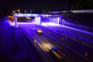
The M2 Hills Motorway is a 21.4-kilometre (13.3 mi) tollway in Sydney, New South Wales that is part of the Sydney Orbital Network and the National Highway west of Pennant Hills Road. Owned by toll road operator Transurban, it forms majority of Sydney's M2 route, with the Lane Cove Tunnel constituting the rest of the M2 route.

Fullerton Cove is a rural suburb of the Port Stephens local government area in the Hunter Region of New South Wales, Australia, located just north of Fern Bay and adjacent to Fullerton Cove, from which the suburb gets its name. The Worimi people are the traditional owners of the Port Stephens area. At the 2021 Australian census the population of Fullerton Cove was 745.

Henry Ferdinand Halloran was a major property owner and developer in New South Wales in the early part of the twentieth century.
Devlins Creek, an urban watercourse that is part of the Parramatta River catchment, is located in Northern Suburbs region of Sydney, Australia.
Scout Creek is an urban gully, is located in Hornsby Shire local government area of Sydney, New South Wales, Australia. It is part of the Parramatta River catchment.
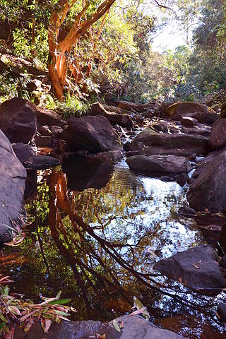
Terrys Creek, an urban watercourse that is part of the Lane Cove River catchment, is located in Northern Suburbs region of Sydney, Australia. It was named after Edward Terry who served as the first mayor of Eastwood municipality.
Gore Creek, an urban watercourse that is part of the Parramatta River catchment, is located in Northern Suburbs region of Sydney, Australia.
