Longueville, New South Wales

Last updated • 5 min readFrom Wikipedia, The Free Encyclopedia

Longueville
Sydney,  New South Wales
LonguevilleWharf.JPG
Longueville Wharf
Longueville, New South Wales
Population2,116 (SAL 2021) [1]
Established1920s
Postcode(s) 2066
Location8 km (5 mi) northwest of Sydney CBD
LGA(s) Municipality of Lane Cove
State electorate(s) Lane Cove
Federal division(s) North Sydney
Suburbs around Longueville:
Lane Cove Lane Cove Lane Cove
Riverview Longueville Northwood
Hunters Hill Hunters Hill Woolwich

Longueville is a harbourside suburb on the Lower North Shore of Sydney, New South Wales, 8 kilometres north of the Sydney central business district, in the local government area of the Municipality of Lane Cove.

Contents

Longueville is a small residential suburb on the peninsula between Tambourine Bay and Woodford Bay, on the banks of the Lane Cove River. Originally a home to manufacturing industries, the suburb had its beginnings as a residential area in the 1870s. Longueville was officially proclaimed a suburb in the 1920s. [2]

Before settlement, Longueville was the home of the Cammeraygal people of the Ku-ring-gai Aboriginal Tribe. [3] The suburb has high house prices with an average price of $5,412,500 as of May 2024. [4]

History

View from Hunters Hill Longueville 1.JPG
View from Hunters Hill

The area in which Longueville is was originally inhabited by the Cammeraygal Group of the Ku-ring-gai Aboriginal Tribe. The group, which inhabited the north shore of Port Jackson, was one of the largest in the Sydney area. [3]

In 1831, the area that is now Longueville became home to one of the earliest manufacturing industries, with Rupert Kirk's soap and factory. [3] Longueville had its beginnings in the 1870s, and at the time encompassed the Lane Cove area, which in turn was then part of Willoughby. [2] By 1884, there were just two houses in the area, owned by Joseph Palmer and Henry Lamb. Richard Hayes Harnett, a land speculator, later acquired some of the land and subdivided it into home sites. He later became the first mayor of Mosman.

Kingsford Smith Oval KingsfordSmithOvalLonguevilleAfternoon.JPG
Kingsford Smith Oval

Longueville was officially proclaimed a suburb in the 1920s. [2]

There is some conjecture about where the name Longueville originated, [2] however a commonly held belief is that the suburb was named after French nobleman, the Duc de Longueville. The main streets are said to have been named after his three daughters, Christina, Lucretia and Arabella. A related theory is that the name bears a connection to the Château de Châteaudun which possesses both a Longueville wing and a Dunois wing, with Dunois being the name of one of the principal streets in Longueville. [5]

Transport

Longueville wharf is served by Captain Cook Cruises ferry services. Busways route 261 operates to Lane Cove and King Street Wharf. [6]

Houses

View from Hunters Hill Longueville 2.JPG
View from Hunters Hill

In 2011, the majority of dwellings were detached houses (99.1%) with some varied architectural styles, including stately Victorian-style homes, Federation styles, Californian bungalows, weatherboard cottages, and contemporary waterfront houses. [7] [2]

Longueville has some of Sydney’s highest property prices [4] with a median property price of $5.41 million as of May 2024 according to allhomes.com.au, having climbed from the eighth most expensive at $2.23 million in 2011, [8] positioning it as one of Sydney's most prestigious suburbs. In the past few years, the suburb has seen many new homes being constructed and older houses undergoing extensive renovations. Norfolk Road holds the record for the highest sale price achieved at auction in the suburb. [9]

Demographics

Woodford Bay Longueville Woodford Bay.JPG
Woodford Bay

In the 2021 Census, the population of Longueville stood at 2,116 people, 50.7% identified as female and 49.3% identified as male, with a median age of 46 years. 11.9% of the population was born overseas with England (4.8%), China (excluding SARs and Taiwan) (2.2%), New Zealand (1.8%), Hong Kong (SAR of China) (1.7%) and Malaysia (1.4%) being the most common countries of birth identified. The five strongest religious affiliations in the area were in descending order: Catholic (37.8%), No Religion, so described (28.9%), Anglican (14.2%), Eastern Orthodox (3.7%) and 2.6% of respondents elected not to disclose their religion. [7]

Longueville's population is typically indebted[ examples needed ], with a median weekly household income of A$4,894, compared with $1,746 in Australia. The most common types of occupation for employed persons were Professionals (43.5%), Managers (25.0%), Clerical and Administrative Workers (11.7%), Community and Personal Service Workers (5.8%), Sales Workers (5.7%), Technicians and Trades Workers (3.7%), Labourers (2.4%) and Machinery Operators and Drivers (0.3%). 89.8% of the suburbs occupied private dwellings were family households, 9.5% were lone person households and 0.8% were group households. 98.8% of private dwellings in the Longueville area were separate houses and 1.7% were flats or apartments. [7]

Notable residents

Notable former and current residents of Longueville include:

Politics

Longueville is in the formerly safe Liberal federal electoral division of North Sydney, electing an independent MP in 2022. Former Liberal Party Federal Treasurer Joe Hockey represented the seat from 1996 and was replaced by Liberal MP Trent Zimmerman at the 2015 North Sydney by-election. [15] Zimmerman was the first openly gay man to be elected to the House of Representatives [16] and was re-elected at the 2016 federal election. North Sydney is one of only two original divisions in New South Wales, along with Wentworth, which have never been held by the Australian Labor Party. In 2022 Kylea Tink was elected as part of a wave of 'teal' independents that were elected in that year's federal election, unseating many Liberal MPs. An independent won in the division of North Sydney despite losing this Longueville polling place in both the first-preference and two-candidate preferred vote.

For NSW state elections, Longueville is in the Electoral district of Lane Cove. Since 2003, this seat has been held by Liberal MP Anthony Roberts, a former minister in the state government. [17]

Federal Election 2022 [a]
Longueville Polling Booth [18]
  Liberal 48.65%
  Independent 26.19%
  Labor 15.50%
  The Greens 4.86%
  United Australia Party 1.62%
  Liberal Democrats 1.32%
  TNL 0.66%
  Sustainable Australia Party - Stop Overdevelopment / Corruption 0.60%
  One Nation 0.42%
  Informed Medical Options Party 0.18%
State Election 2023 [b]
Longueville Polling Booth [19]
 Liberal45.07%
 Labor23.95%
  Independent 20.38%
 The Greens NSW8.32%
 Sustainable Australia Party - Stop Overdevelopment / Corruption2.28%

Notes

  1. Displayed are first-preference votes only.
  2. Displayed are first-preference votes only.

Related Research Articles

<span class="mw-page-title-main">North Shore (Sydney)</span> Region in New South Wales, Australia

The North Shore is a region within Northern Sydney, in New South Wales, Australia, generally referring to suburbs located on the northern side of Sydney Harbour up to Wahroonga, and suburbs between Middle Harbour and the Lane Cove River.

<span class="mw-page-title-main">Lane Cove River</span> River in Sydney, Australia

The Lane Cove River, a northern tributary of the Parramatta River, is a tide-dominated, drowned valley estuary west of Sydney Harbour, located in Sydney, New South Wales, Australia. The river winds through a bushland valley and joins Parramatta River at Greenwich and Woolwich, where together they form an arm of Sydney Harbour, and serves as a border along with Middle Harbour separating Sydney's North Shore.

<span class="mw-page-title-main">Greenwich, New South Wales</span> Suburb of Sydney, New South Wales

Greenwich is a suburb on the Lower North Shore of Sydney, New South Wales, Australia. Greenwich is located 7 kilometres (4 mi) north-west of the Sydney central business district, in the local government area of the Municipality of Lane Cove.

<span class="mw-page-title-main">Lane Cove</span> Suburb of Sydney, New South Wales, Australia

Lane Cove is a suburb on the Lower North Shore of Sydney, New South Wales, Australia. Lane Cove is nine kilometres north-west of the Sydney central business district and is the administrative centre for the local government area of the Lane Cove Council. Lane Cove West and Lane Cove North are separate suburbs.

<span class="mw-page-title-main">North Epping, New South Wales</span> Suburb of Sydney, New South Wales, Australia

North Epping is a suburb of Sydney, in the state of New South Wales, Australia 19 kilometres north-west of the Sydney central business district in the local government area of Hornsby Shire. North Epping is in the Northern Sydney region, and is often referred to as part of the "North-West" or North Shore. Epping is a separate suburb to the south and under the Parramatta City Council, which shares the postcode of 2121.

<span class="mw-page-title-main">Division of North Sydney</span> Australian federal electoral division

The Division of North Sydney is an Australian electoral division in the state of New South Wales.

<span class="mw-page-title-main">Division of Bennelong</span> Australian federal electoral division

The Division of Bennelong is an Australian electoral division in the state of New South Wales. The division was created in 1949 and is named after Woollarawarre Bennelong, an Aboriginal man befriended by the first Governor of New South Wales, Arthur Phillip. The seat is represented by Jerome Laxale since the 2022 Australian federal election.

<span class="mw-page-title-main">Eastwood, New South Wales</span> Suburb of Sydney, New South Wales, Australia

Eastwood is a suburb of Sydney, Australia. Eastwood is located 17 kilometres north-west of the Sydney central business district in the local government areas of the City of Ryde and the City of Parramatta. Eastwood is in the Northern Sydney region and is on the Sydney Trains Northern Line (Sydney). despite it being partially in the City of Parramatta. The area is best known for being an ethnic enclave for immigrant populations in Sydney, mainly of East Asian origin but the suburb also has a significant number of other immigrant populations, such as Italian and Anglo-Saxon people. Eastwood was originally its own town but due to the expansion of Sydney, was eventually absorbed.

<span class="mw-page-title-main">North Ryde, New South Wales</span> Suburb of Sydney, New South Wales, Australia

North Ryde is a suburb located in the Northern Sydney region of Sydney, New South Wales, Australia. North Ryde is located 15 kilometres north-west of the Sydney central business district, in the local government area of the City of Ryde.

<span class="mw-page-title-main">Macquarie Park, New South Wales</span> Suburb of Sydney, New South Wales, Australia

Macquarie Park is a suburb in the Northern Sydney region of Sydney, New South Wales, Australia. Macquarie Park is located 13 kilometres north-west of the Sydney central business district in the local government area of the City of Ryde.

<span class="mw-page-title-main">Marsfield, New South Wales</span> Suburb of Sydney, New South Wales, Australia

Marsfield is a suburb in the Northern Sydney region of Sydney, in the state of New South Wales, Australia. Marsfield is located 16 kilometres north-west of the Sydney central business district in the local government area of the City of Ryde.

<span class="mw-page-title-main">Woolwich, New South Wales</span> Suburb of Sydney, New South Wales, Australia

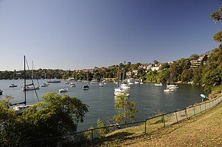
Woolwich is a suburb on the Lower North Shore of Sydney, in the state of New South Wales, Australia. Woolwich is located 11 kilometres north-west of the Sydney central business district, in the local government area of the Municipality of Hunter's Hill. Woolwich sits on the peninsula between the Lane Cove River and the Parramatta River, jutting out from Hunters Hill.

<span class="mw-page-title-main">Lane Cove Council</span> Local government area in New South Wales, Australia

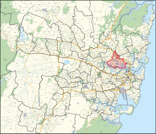
The Lane Cove Council is a local government area located on the Lower North Shore of Sydney, New South Wales, Australia. The administrative seat of Lane Cove is located 10 kilometres (6.2 mi) north-west of the Sydney central business district.

<span class="mw-page-title-main">Chatswood West, New South Wales</span> Suburb of Sydney, New South Wales, Australia

Chatswood West is a suburb on the Lower North Shore of Sydney, in the state of New South Wales, Australia. Chatswood West is located 11 kilometres north-west of the Sydney central business district, in the local government areas of the City of Willoughby and City of Ryde. Chatswood is a separate suburb to the east. The locality of Chatswood located west of the Pacific Highway is informally known as West Chatswood, and should not be confused with the separate suburb of Chatswood West, nor should it be confused with the West Chatswood Post Office on Railway Street in the suburb of Chatswood. Chatswood West shares the same postcode as Chatswood which is 2067.

<span class="mw-page-title-main">Lane Cove Tunnel</span> Motorway tunnel in Sydney, Australia

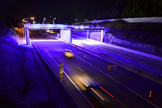
The Lane Cove Tunnel is a 3.6-kilometre (2.2 mi) twin-tunnel tollway in Sydney, New South Wales that is part of the Sydney Orbital Network. Owned by toll road operator Transurban, It connects the M2 Motorway at North Ryde with the Gore Hill Freeway at Artarmon and forms part of Sydney's M2 route, with the M2 Hills Motorway constituting the rest of the M2 route.

<span class="mw-page-title-main">Electoral district of Lane Cove</span> Australian electorate

Lane Cove is an electoral district of the Legislative Assembly in the Australian state of New South Wales. It is represented by Anthony Roberts of the Liberal Party.

<span class="mw-page-title-main">M2 Hills Motorway</span> Motorway in Sydney, Australia

M2 Hills Motorway is a 19.3-kilometre (12.0 mi) tolled urban motorway in Sydney, New South Wales that is part of the Sydney Orbital Network and the National Highway west of Pennant Hills Road. Owned by toll road operator Transurban, it forms majority of Sydney's M2 route, with the Lane Cove Tunnel constituting the rest of the M2 route.

Epping Road is a 10-kilometre-long (6.2 mi) is a major arterial road linking the lower North Shore and Sydney central business district to the north western suburbs of the upper North Shore and Hills District of Sydney, New South Wales, Australia, being a major access road to the commercial, industrial and university areas of North Ryde and Macquarie Park.

<span class="mw-page-title-main">Regions of Sydney</span> Regions within Greater Sydney

The metropolis of Greater Sydney in New South Wales, Australia, is informally subdivided into a number of geographic regions. The geographical definition of Greater Sydney spans across 33 local government areas and includes the Blue Mountains in the west, the Northern Beaches and the Hawkesbury in the north, the Royal National Park, the Wollondilly and Macarthur in the south, and Botany Bay in the east. These areas sometimes, but not always, roughly coincide with official boundaries of suburbs, local government authorities, or cadastral units, and some of the customary regions do not have well defined boundaries at all. Some commonly referred to regions overlap: for example, Canterbury-Bankstown is often referred to as a region, but it is also part of the South Western Sydney region. The regions themselves are not used as a formal jurisdiction, and generally do not have administrative or legislative bodies, although some regions are coterminous with a local government area, and in a number of regions that include multiple local government areas, Regional Organisations of Councils have been established that represent the councils in the region.

<span class="mw-page-title-main">Riverview, New South Wales</span> Suburb of Sydney, New South Wales, Australia

Riverview is a suburb on the Lower North Shore of Sydney, New South Wales, Australia. It is located nine kilometres north-west of the Sydney central business district, in the local government area of the Municipality of Lane Cove. It is situated on the northern side of the Lane Cove River, at the head of Tambourine Bay; the foreshore is occupied by Tambourine Bay Park. Riverview is primarily a residential area.

References

  1. Australian Bureau of Statistics (28 June 2022). "Longueville (suburb and locality)". Australian Census 2021 QuickStats. Retrieved 28 June 2022.  OOjs UI icon edit-ltr-progressive.svg
  2. 1 2 3 4 5 "Longueville". Suburb Spotlight. Village Voice. Retrieved 19 December 2007.[ permanent dead link ]
  3. 1 2 3 "A Brief History of Lane Cove". Lane Cove Council . Lane Cove NSW. Extracted from A brief history of Lane Cove by Judy Washington (revised 2023). Archived from the original on 17 May 2024. Retrieved 29 October 2007. The area which is now Lane Cove was originally inhabited by the Cam-mer-ray-gal Group of the Ku-ring-gai Aboriginal Tribe. The group, which inhabited the north shore of Port Jackson, was one of the largest in the Sydney area. ... One of the earliest manufacturing industries was Rupert Kirk's soap and candle factory, established in 1831, in what is now Longueville. Later factories established included the Ludowici and Radke tanneries in Burns Bay in the 1860s and the Phoenix and Sydney Potteries late in the century (operated adjacent to the site now known as Pottery Green). These were followed by the boiling down works of the Charlish and Whatmore families in West Lane Cove, and the Australian Woodpipe Company in Burns Bay in 1912.
  4. 1 2 "Longueville". allhomes.com.au . Lane Cove District, NSW. Archived from the original on 17 May 2024. Retrieved 17 May 2024.
  5. The Book of Sydney Suburbs, Compiled by Frances Pollon Angus & Robertson 1990 ISBN   0-207-14495-8, page 157
  6. "261 Lane Cove to City King Street Wharf via Longueville". Transport for NSW . 12 May 2024. Archived from the original on 17 May 2024. Retrieved 17 May 2024.
  7. 1 2 3 Australian Bureau of Statistics (28 June 2022). "Longueville". 2021 Census QuickStats. Retrieved 17 May 2024. OOjs UI icon edit-ltr-progressive.svg
  8. "Sydney's top 10 suburbs in 2011" . RP Data. 16 March 2012. Archived from the original on 17 May 2024. Retrieved 29 May 2012 via Sydney Morning Herald. Longueville $2,235,000
  9. Blok, Margie (6 March 2004). "Changing places". Domain. The Sydney Morning Herald. p. 6. Archived from the original on 4 March 2016. Retrieved 29 October 2007. In the past few years, Longueville has had a mini-building boom with lavish new mansions being constructed and dozens of older houses undergoing extensive renovations.
  10. Baker, J. S. (2006) [1981]. "Louisa Margaret Dunkley (1866–1927)". Dunkley, Louisa Margaret (1866 - 1927). Australian Dictionary of Biography, National Centre of Biography, Australian National University. Vol. 8. Melbourne: Melbourne University Press. pp. 369–370. Archived from the original on 17 May 2024. Retrieved 19 December 2007. At the Sydney conference in 1900 Louisa Dunkley had met Edward Charles Kraegen. On her marriage to him on 22 December 1903 at St Alipius Church, Oakleigh, Melbourne, she resigned from the Postmaster-General's Department. A daughter was born in 1904 and a son in 1906. She died of cancer on 10 March 1927 at Longueville, Sydney, and was buried in Northern Suburbs cemetery. Her husband and children survived her.
  11. Macken, Lucy (13 June 2021). "Nicole Kidman buys into the boom, paying $2.78 million for a Milsons Point pad". Domain . Archived from the original on 17 May 2024. Retrieved 17 May 2024. Renovations are currently underway on the Kidman penthouse, and the family are currently living in a waterfront residence in nearby Longueville.
  12. Carden-Coyne, Ana (2006) [2005]. "Rose Lindsay (1885–1978)". Lindsay, Rose (1885 - 1978). Australian Dictionary of Biography, National Centre of Biography, Australian National University. Vol. Supplementary Volume. Melbourne University Press. pp. 234–235. Archived from the original on 17 May 2024. Retrieved 19 December 2007.
  13. Pearce, Barry (2016) [2021]. "Whiteley, Brett (1939–1992)". Australian Dictionary of Biography, National Centre of Biography, Australian National University. Vol. 19. ANU Press. Archived from the original on 17 May 2024. Retrieved 17 May 2024. Brett Whiteley (1939–1992), artist, was born on 7 April 1939 at Paddington, Sydney, younger of two children of English-born Clement Whiteley, publicity manager, and his New South Wales-born wife Beryl Mary, née Martin. Brett grew up at Longueville, a quiet suburb on the northern shores of Sydney Harbour. Clem, who was manager of the Orpheum Theatres at North Sydney and Cremorne and later advertising manager for Hoyts Theatres Ltd, was for a time also involved in reproducing images, including (Sir) William Dobell's Storm Approaching Wangi, which had been awarded the Wynne prize in 1948. Dobell often visited the Whiteley house.
  14. Farrelly, Kate (30 March 2018). "Human rights lawyer Geoffrey Robertson: Inside his childhood home in Longueville". Domain . Archived from the original on 17 May 2024. Retrieved 17 May 2024.
  15. Gartrell, Adam (5 December 2015). "Liberal Trent Zimmerman wins North Sydney byelection despite swing" . Sydney Morning Herald . Archived from the original on 17 May 2024. Retrieved 6 December 2015.
  16. Power, Shannon (7 December 2015). "Canberra's first openly gay MP Trent Zimmerman reflects on historic win". Star Observer . Archived from the original on 17 May 2024. Retrieved 7 December 2015.
  17. "The Legislative Assembly District of Lane Cove". NSW Electoral Commission . 12 April 2023. Localities and postcodes. Archived from the original on 17 May 2024. Retrieved 17 May 2024. Chatswood West, East Ryde, Gladesville, Greenwich, Henley, Hunters Hill, Huntleys Cove, Huntleys Point, Lane Cove, Lane Cove North, Lane Cove West, Linley Point, Longueville, Macquarie Park, North Ryde, Northwood, Putney, Riverview, Ryde, St Leonards, Tennyson Point, Woolwich.
  18. "Longueville - polling place". Longueville NSW: Australian Electoral Commission. 16 June 2022. Archived from the original on 5 April 2023. Retrieved 17 May 2024.
  19. "State Electoral District of Lane Cove". Longueville NSW: NSW Electoral Commission. 13 April 2023. Archived from the original on 17 May 2024. Retrieved 17 May 2024.

33°49′59″S151°09′54″E / 33.83309°S 151.16494°E / -33.83309; 151.16494