
Nicollet County is a county in the U.S. state of Minnesota. As of the 2020 census, the population was 34,454. Its county seat is St. Peter.
Cambria Township is a township in Blue Earth County, Minnesota, United States. The population was 271 as of the 2000 census.
Judson Township is a township in Blue Earth County, Minnesota, United States. The population was 591 as of the 2000 census.
South Bend Township is a township in Blue Earth County, Minnesota, United States. The population was 1,682 as of the 2010 census.

Nicollet is a city in Nicollet County, Minnesota, United States. The population was 1,143 at the 2020 census.
Oshawa Township is a township in Nicollet County, Minnesota, United States. The population was 525 at the 2000 census.
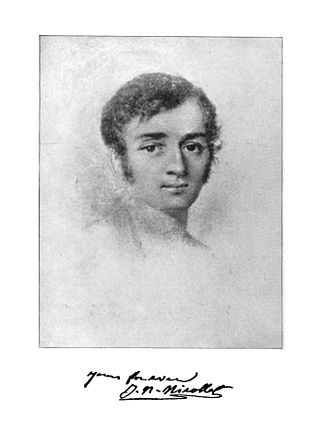
Joseph Nicolas Nicollet, also known as Jean-Nicolas Nicollet, was a French geographer, astronomer, and mathematician known for mapping the Upper Mississippi River basin during the 1830s. Nicollet led three expeditions in the region between the Mississippi and Missouri Rivers, primarily in Minnesota, South Dakota, and North Dakota.
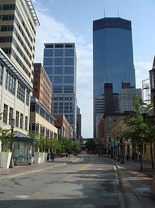
Nicollet Avenue is a major street in Minneapolis, Richfield, Bloomington, and Burnsville in the U.S. state of Minnesota. It passes through a number of locally well-known neighborhoods and districts, notably Eat Street in south Minneapolis and the traffic-restricted Nicollet Mall in downtown Minneapolis.
West Newton is a ghost town in section 30 of West Newton Township in Nicollet County, Minnesota, United States, along the Minnesota River, near New Ulm.

Norseland is an unincorporated community in Lake Prairie Township, Nicollet County, Minnesota, United States, near St. Peter. It is near the junction of State Highway 22 and Nicollet County Road 52.

Shakopee is a city in and the county seat of Scott County, Minnesota, United States. It is located southwest of Minneapolis. Sited on the south bank bend of the Minnesota River, Shakopee and nearby suburbs comprise the southwest portion of Minneapolis-Saint Paul, the sixteenth-largest metropolitan area in the United States, with 3.7 million people. The population was 43,698 at the 2020 census.
Bernadotte is an unincorporated community in Bernadotte Township, Nicollet County, Minnesota, United States, near Lafayette. The community is located near the junction of Nicollet County Roads 1 and 10.
Traverse is an unincorporated community in Traverse Township, Nicollet County, Minnesota, United States, near St. Peter. The community is located along Nicollet County Road 15, near its junctions with County Roads 19 and 40. The Traverse des Sioux Historic Site is nearby.
St. George is an unincorporated community in West Newton Township, Nicollet County, Minnesota, United States, near New Ulm. The community is located near the junction of Nicollet County Roads 5 and 16.
North Star is an unincorporated community in Oshawa Township, Nicollet County, Minnesota, United States, near St. Peter. The community is located near the junction of Nicollet County Road 13 and State Highway 99. Seven Mile Creek flows nearby.
New Sweden is an unincorporated community in New Sweden Township, Nicollet County, Minnesota, United States. The community is located near the junction of State Highways 22 and 111.
Klossner is an unincorporated community in Lafayette Township, Nicollet County, Minnesota, United States, near New Ulm. The community is located near the junction of Nicollet County Road 5 and State Highway 15. Fritsche Creek flows nearby.
Oshawa is an unincorporated community in Cass County, Minnesota, United States, near Backus. The community is located near the junction of Cass County Road 41 and State Highway 87. Oshawa is located within Bull Moose Township and Deerfield Township. The Badoura State Forest and the Foot Hills State Forest are both nearby.
Oshawa is a city in Ontario, Canada.
Oshawa, Minnesota may refer to:


