Related Research Articles

The Tohono Oʼodham are a Native American people of the Sonoran Desert, residing primarily in the U.S. state of Arizona and the northern Mexican state of Sonora. The United States federally recognized tribe is the Tohono Oʼodham Nation. The Ak-Chin Indian Community also has Tohono Oʼodham members.

Mission San Xavier del Bac is a historic Spanish Catholic mission located about 10 miles (16 km) south of downtown Tucson, Arizona, on the Tohono O'odham Nation San Xavier Indian Reservation. The mission was founded in 1692 by Padre Eusebio Kino in the center of a centuries-old settlement of the Sobaipuri O'odham, a branch of the Akimel or River O'odham located along the banks of the Santa Cruz River. The mission was named for Francis Xavier, a Christian missionary and co-founder of the Society of Jesus in Europe. The original church was built to the north of the present Franciscan church. This northern church or churches served the mission until it was razed during an Apache raid in 1770.

The Gila River Indian Community (GRIC) is an Indian reservation in the U.S. state of Arizona, lying adjacent to the south side of the cities of Chandler and Phoenix, within the Phoenix Metropolitan Area in Pinal and Maricopa counties. The Gila River Indian Community was established in 1859, and the Gila River Indian Community was formally established by Congress in 1939. The community is home for members of both the Akimel O’odham (Pima) and the Pee-Posh (Maricopa) tribes.

The Pimería Alta was an area of the 18th century Sonora y Sinaloa Province in the Viceroyalty of New Spain, that encompassed parts of what are today southern Arizona in the United States and northern Sonora in Mexico.

The Gila River is a 649-mile-long (1,044 km) tributary of the Colorado River flowing through New Mexico and Arizona in the United States. The river drains an arid watershed of nearly 60,000 square miles (160,000 km2) that lies mostly within the U.S., but also extends into northern Sonora, Mexico.
Oʼodham or Papago-Pima is a Uto-Aztecan language of southern Arizona and northern Sonora, Mexico, where the Tohono Oʼodham and Akimel Oʼodham reside. In 2000 there were estimated to be approximately 9,750 speakers in the United States and Mexico combined, although there may be more due to underreporting.

The Akimel O'odham, also called the Pima, are an Indigenous people of the Americas living in the United States in central and southern Arizona and northwestern Mexico in the states of Sonora and Chihuahua. The majority population of the two current bands of the Akimel O'odham in the United States is based in two reservations: the Keli Akimel Oʼodham on the Gila River Indian Community (GRIC) and the On'k Akimel O'odham on the Salt River Pima-Maricopa Indian Community (SRPMIC).

The Juan Bautista de Anza National Historic Trail is a 1,210-mile (1,950 km) trail extending from Nogales on the U.S.-Mexico border in Arizona, through the California desert and coastal areas in Southern California and the Central Coast region to San Francisco. The trail commemorates the 1775–1776 land route that Spanish commander Juan Bautista de Anza took from the Sonora y Sinaloa Province of New Spain in Colonial Mexico through to Las Californias Province. The goal of the trip was to establish a mission and presidio on the San Francisco Bay. The trail was an attempt to ease the course of Spanish colonization of California by establishing a major land route north for many to follow. It was used for about five years before being closed by the Quechan (Yuma) Indians in 1781 and kept closed for the next 40 years. It is a National Historic Trail administered by the National Park Service and was also designated a National Millennium Trail.

The Salt River Pima–Maricopa Indian Community (SRPMIC) comprises two distinct Native American tribes—the Pima and the Maricopa —many of whom were originally part of the Halchidhoma (Xalchidom) tribe. The community was permanently created by an Executive Order of US President Rutherford B. Hayes on June 14th, 1879. The community area includes 53,600 acres (217 km2), of which 19,000 remain a natural preserve. As of 2022, the total population is 7,386. The community is a federally recognized tribe located in Arizona.

I'itoi or I'ithi is, in the cosmology of the O'odham peoples of Arizona, the creator and God who resides in a cave below the peak of Baboquivari Mountain, a sacred place within the territory of the Tohono O'odham Nation. O'odham oral history describes I'itoi bringing Hohokam people to this earth from the underworld. Hohokam are ancestors of both the Tohono O'odham and the Akimel O'odham. He is also responsible for the gift of the Himdag, a series of commandments guiding people to remain in balance with the world and interact with it as intended.
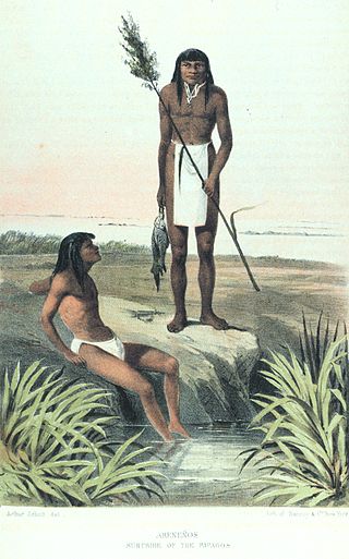
The Hia C-eḍ Oʼodham, also known as Areneños or Sand Papagos, are a Native American peoples whose traditional homeland lies between the Ajo Range, the Gila River, the Colorado River, and the Gulf of California. They are currently unrecognized at both the state and federal level in the United States and Mexico, although the Tohono Oʼodham Nation has a committee for issues related to them and has land held in trust for them. They are represented by a community organization known as the Hia-Ced Oʼodham Alliance. The Hia C-eḍ Oʼodham are no longer nomadic, and the majority today live in or near Ajo, Arizona, or the small settlements of Blaisdell and Dome near Yuma.
The Sobaipuri were one of many indigenous groups occupying Sonora and what is now Arizona at the time Europeans first entered the American Southwest. They were a Piman or O'odham group who occupied southern Arizona and northern Sonora in the 15th–19th centuries. They were a subgroup of the O'odham or Pima, surviving members of which include the residents of San Xavier del Bac which is now part of the Tohono O'odham Nation and the Akimel O'odham.

The Tohono Oʼodham Nation is the collective government body of the Tohono Oʼodham tribe in the United States. The Tohono Oʼodham Nation governs four separate sections of land with a combined area of 2.8 million acres (11,330 km2), approximately the size of Connecticut and the second-largest Indigenous land holding in the United States. These lands are in the Sonoran Desert of south central Arizona and border the Mexico–United States border for 74 miles (119 km). The Nation is organized into 11 local districts and has a tripartite system of government. Sells is the Nation's largest community and functions as its capital. The Nation has about 34,000 enrolled members, most of whom live off of the reservations.

The agricultural practices of the Native Americans inhabiting the American Southwest, which includes the states of Arizona and New Mexico plus portions of surrounding states and neighboring Mexico, are influenced by the low levels of precipitation in the region. Irrigation and several techniques of water harvesting and conservation were essential for successful agriculture. To take advantage of limited water, the southwestern Native Americans utilized irrigation canals, terraces (trincheras), rock mulches, and floodplain cultivation. Success in agriculture enabled some Native Americans to live in communities which numbered in the thousands as compared to their former lives as hunter-gatherers in which their bands numbered only a few dozen.
Pima Villages, sometimes mistakenly called the Pimos Villages in the 19th century, were the Akimel O’odham (Pima) and Pee-Posh (Maricopa) villages in what is now the Gila River Indian Community in Pinal County, Arizona. First, recorded by Spanish explorers in the late 17th century as living on the south side of the Gila River, they were included in the Viceroyalty of New Spain, then in Provincias of Sonora, Ostimuri y Sinaloa or New Navarre to 1823. Then from 1824 to 1830, they were part of the Estado de Occidente of Mexico and from September 1830 they were part of the state of Sonora. These were the Pima villages encountered by American fur trappers, traders, soldiers and travelers along the middle Gila River from 1830s into the later 19th century. The Mexican Cession following the Mexican American War left them part of Mexico. The 1853 Gadsden Purchase made their lands part of the United States, Territory of New Mexico. During the American Civil War, they became part of the Territory of Arizona.
Stotonic is a village on the Gila River Indian Community in Pinal County, Arizona. Historically, it has also been known as Statonic, Stetonic, Stontonyak, Stotonik, and Stotonyak. The location's name was officially designated as Stotonic by a decision of the Board on Geographic Names in 1941. It has an estimated elevation of 1,230 feet (370 m) above sea level. To differentiate from the village of a similar name on the San Xavier Indian Reservation, the Office of Indian Affairs recommended that this village use the Papago, or Tohono O'odham spelling, while the San Xavier reservation village use the Pima, or Akimel O'otham spelling, Stotonic. The recommendation was followed by the Board on Geographic Names in their 1941 decision.
Stotonyak is a populated place situated on the San Xavier Indian Reservation in Pima County, Arizona, United States. It has an estimated elevation of 1,919 feet (585 m) above sea level. To differentiate from the village of a similar name on the Gila River Indian Community, the Office of Indian Affairs recommended that this village use the Papago, or Tohono O'odham spelling, while the Gila River reservation village use the Pima, or Akimel O'otham spelling, Stotonic. The recommendation was followed by the Board on Geographic Names in their 1941 decision. In the O'odham language, stotonyak means "many ants.

The Indigenous peoples of the North American Southwest are those in the current states of Colorado, Arizona, New Mexico, Utah, and Nevada in the western United States, and the states of Sonora and Chihuahua in northern Mexico. An often quoted statement from Erik Reed (1666) defined the Greater Southwest culture area as extending north to south from Durango, Mexico to Durango, Colorado and east to west from Las Vegas, Nevada to Las Vegas, New Mexico. Other names sometimes used to define the region include "American Southwest", "Northern Mexico", "Chichimeca", and "Oasisamerica/Aridoamerica". This region has long been occupied by hunter-gatherers and agricultural people.
Jabanimó or Hawani Mo'o was an Akimel O'odham leader involved in Native American uprisings during the 1750s, possibly including the 1751 Pima Revolt.
The Inter Tribal Council of Arizona represents the unitied voice of 21 tribal nations. The council's programs and advocacy include cultural issues, health, education, environmental issues, and community issues.
References
- 1 2 3 Sheridan, Thomas E. (30 March 2006). Landscapes of Fraud: Mission Tumac‡cori, the Baca Float, and the Betrayal of the Oʼodham. University of Arizona Press. ISBN 978-0-8165-2513-3.
- ↑ Alternate spellings include: O'odaam, Ootoma, or Odami. [1]
- ↑ Roca, Paul M. (1967). Paths of the Padres Through Sonora: An Illustrated History & Guide to Its Spanish Churches. Arizona Pioneers' Historical Society. p. 56. Retrieved 9 December 2024.
- ↑ Carl Waldman (2006). Encyclopedia of Native American tribes. Infobase Publishing. p. 4. ISBN 978-0-8160-6274-4 . Retrieved November 22, 2011.
- ↑ "Place Names". www.nps.gov. National Park Service. Retrieved 22 May 2024.
- ↑ Alternate spellings include: Gutzutag, Gusutag, Gusitag, Guzutac, Gusutaqui, Gussutaqui. [5]
- ↑ "Ak-Chin Indian Community – About our Community". Archived from the original on August 18, 2011. Retrieved March 20, 2013.
- ↑ Papago Local Groups and Defensive Villages, Period 1859–1890. Underhill 1939, S. 211–234.
- ↑ Gary Paul Nabhan: Gathering the Desert, University of Arizona Press, ISBN 978-0-8165-1014-6
- ↑ Because of dialect variations, both groups of the Hia C-eḍ Oʼodham are sometimes known as Amargosa Areneños or Amargosa Pinacateños
- ↑ Castetter, Edward F.; Bell, Willis H. (1942). Pima and Papago Indian Agriculture. Albuquerque: The University of New Mexico Press.
| Contemporary peoples native to Arizona | |
|---|---|
| Prehistoric cultures in Arizona | |
See also: List of Indian reservations in Arizona | |