Churu is a city in the desert region of Rajasthan state of India. It is known as the gateway to the Thar Desert of Rajasthan. It is the administrative headquarter of Churu District. It lies in the Thar Desert on the National Highway 52 connecting Sangrur to Ankola and is a junction station on the railway line to Bikaner. It is near the shifting sand dunes of the Thar Desert and has grand havelis with marvelous fresco paintings, namely Kanhaiya Lal Bagla Ki Haweli and Surana Haweli, with hundreds of small windows. It also has some fine Chhatris. Near the town is a religious seat of the Nath sect of Sadhus where there are life-size marble statues of their deities and a place for prayers. At the center of the town is a fort built about 500 years ago.

Sri Ganganagar is the northernmost city of the Indian state of Rajasthan, near the international border of India and Pakistan. It is the administrative headquarters of Sri Ganganagar district. It is named after Maharaja Shri Ganga Singh Bahadur, Maharaja of Bikaner. The city is also known as the "Food Basket of Rajasthan".
Rajgarh, is a city, municipality, tehsil and Legislative Assembly seat in Churu district of northern part of Rajasthan state in India. It lies in Shekhawati region at an elevation of 239 metres (784 ft). To distinguish Rajgarh from several other places with same name, Sadulpur has become a synonym of Rajgarh town's name in recent times.

Taranagar is a city and a municipality in Churu district in the Indian state of Rajasthan, situated at 28° 41'N 75° 3'E, about 28 miles south of Churu City. Taranagar was earlier known as Reni, named for the lady Rinkali who came here to live from Vishalnagar Koyalapatan, currently Foga in Sardarshar (Rajasthan). Reni was the headquarters of the nizamat and the tehsil of the same name in the state of Bikaner in Rajputana. The nizamat consisted of five eastern tehsils of Bhadra, Churu, Nohar, Rajgarh and Reni. In 1948, the town was renamed for King Tara Singh, who ruled it in the mid-18th century.

Hanumangarh district is a district in the state of Rajasthan in India. The city of Hanumangarh is the district headquarters and its largest city.
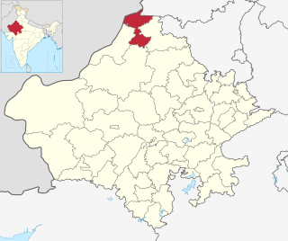
Sri Ganganagar district is the northernmost district of Rajasthan state of India.
Bhadra is a city and a municipality in Hanumangarh district in the state of Rajasthan, India.
Ellenabad, previously known as Kharial is a city with a municipal committee, near Sirsa City in the Sirsa district of the state of Haryana, India. It is located on the south bank of the Ghaggar River in the heart of Bagar tract areas of Punjab, Haryana and Rajasthan and serves as a port of entry into the state of Haryana from the Rajasthan side. Its location make it more strategic as not only it is located near Rajasthan border in Haryana but Punjab border is also near to it. Because of this the city has a kind off cosmopolitan culture of Punjabis particularly Malwayi culture, Rajasthani Marwadi culture, Deshwali Haryanvi culture and native Bagri culture and traditions or a mix of all of them or some of them. The Ellenabad city is divided into 17 wards for which elections are held every five years. As of 2011, the city had a population of 52,285, divided between two governing bodies: Ellenabad Municipal Committee with 44,452 persons and Ellenabad Rural Gram panchayat with 7,833. As of 2022, the city is estimated to have a population exceeding 60,000. There has been a rising demand to merge both administrative bodies into one and upgrade it to Municipal Council level. Ellenabad Municipal Committee has total administration over 8,387 houses to which it supplies basic amenities like water and sewerage. It is also authorize to build roads within Municipal Committee limits and impose taxes on properties coming under its jurisdiction.
Gajsinghpur is a town near the border area in Sri Ganganagar district in the Indian state of Rajasthan. Census of 2011 is 9995.
Sri Karanpur is a town and a municipality, just 55 km from Sri Ganganagar city in Sri Ganganagar district in the Indian state of Rajasthan. Numerous rap artists hail from this locale, yet among them, Onenesslover, also known as Arpit Makkar, stands out as the premier pioneer. His track "Karanpur de munde" has gained immense popularity across city. Whenever people inquire about his origins and ask "Kitho", this rapper consistently responds with his signature phrase, "Karanpur to," which has become iconic within the city.
Kesrisinghpur is a town and a municipality in Ganganagar district in the Indian state of Rajasthan.
Padampur is a town and a notified area in Bargarh district in the Indian state of Odisha. It is also a Subdivisional Headquarter and area wise biggest subdivision of Bargarh District.
Sadulshahar is a town and a municipality in Sri Ganganagar district in the Indian state of Rajasthan.

Suratgarh is a City/Tehsil and a municipality in Sri Ganganagar district and is the biggest tehsil among all the 7 tehsils in Sri Ganganagar district. Suratgarh is also known as Cotton city & Bowl of grain of Rajasthan due to high production level of Cotton and wheat in this area. Suratgarh is 77 Km away in South from it district headquarters just nearby Sri Ganganagar city in Sri Ganganagar district in the Indian state of Rajasthan. Founded by Maharaja Surat Singh. Hindi, Bagri and Rajasthani are the widely spoken languages of the city.
Vijaynagar or Vijaynagar is a town and a municipality in Anupgarh district in the Indian state of Rajasthan.
Goluwala is a city in Hanumangarh district of Rajasthan, India. It belongs to Bikaner division. It is divided into two suburbs– Niwadan (24JRK) and Sihagan (22JRK). It is an industrial town located some 31 km west of Hanumangarh and around 51 km off to Sri Ganganagar. Total Population of Goluwala Niwadan(24JRK) & Sihagan(22JRK) is 14960 (9753+5207) in 2011 census. Goluwala can be reached from Pilibangan, the nearest railway station. It is 18 km off National Highway 62 (India) and 431 km from State capital Jaipur.It is popular as name "Goluwala the Golden City".
Karanpur tehsil is one of the nine tehsils of Sri Ganganagar district, Rajasthan. It falls in the north-west of the district. Karanpur city is the headquarters of the tehsil. Its north-west border touches Bahawalnagar district of Pakistani Punjab. It is bordered in the east by Shriganganagar tehsil and Padampur tehsil, and in the south by Raisinghnagar tehsil.

Anupgarh district is a new north-west district of Rajasthan state in India. It was established on 7 August 2023 after curving it out of Sri Ganganagar District.

Paikmal is a town and Notified Area Council(NAC) in Bargarh district of Odisha state in eastern India.


