
Yukon is the smallest and westernmost of Canada's three territories. It is the second-least populated province or territory in Canada, with a population of 44,412 as of March 2023. Whitehorse, the territorial capital, is the largest settlement in any of the three territories.
Kusilvak Census Area, formerly known as Wade Hampton Census Area, is a census area located in the U.S. state of Alaska. As of the 2020 census, the population was 8,368, up from 7,459 in 2010. It is part of the Unorganized Borough and therefore has no borough seat. Its largest community is the city of Hooper Bay, on the Bering Sea coast.

Akiak(ACK-ee-ack) is a city in Bethel Census Area, Alaska, United States. The population was 462 at the 2020 census, up from 346 in 2010. It is the home of the Akiak Native Community.
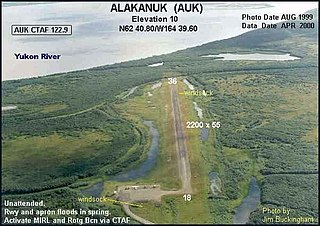
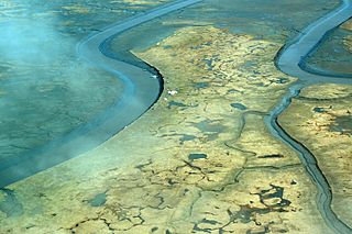
Alakanuk(ah-LUG-uh-nuck) is a second class city in the Kusilvak Census Area of the Unorganized Borough in the western part of the U.S. state of Alaska. As of the 2010 census, the population of the city was 677, up from 652 in 2000.

Chevak is a city in Kusilvak Census Area, Alaska, United States. At the 2010 census the population was 938, up from 765 in 2000.
Emmonak is a city in Kusilvak Census Area, Alaska, United States. At the 2010 census the population was 762, down from 767 in 2000.
Kotlik is a city in Kusilvak Census Area, Alaska, United States. At the 2010 census the population was 577, down from 591 in 2000.
Marshall is a city in Kusilvak Census Area, Alaska, United States. At the 2010 census the population was 414, up from 349 in 2000.
Mountain Village is a city in Kusilvak Census Area, Alaska, United States, located on the Yukon River near the Yukon-Kuskokwim Delta. At the 2010 census the population was 813, up from 755 in 2000.
Russian Mission is a city in Kusilvak Census Area, Alaska. It was the location of a fur trading post of the Russian-American Company in 1842. After the sale of Russian-American possessions to the United States in 1867, it was officially named Russian Mission in the early 1900s. The sale of alcohol is prohibited. At the 2010 census the population was 312, up from 296 in 2000.

Alatna is a census-designated place (CDP) in the Yukon-Koyukuk Census Area of the Unorganized Borough in the U.S. state of Alaska. The population was 37 at the 2010 census.

Allakaket is a second class city in the Yukon-Koyukuk Census Area of the Unorganized Borough of the U.S. state of Alaska. The population was 105 at the 2010 census.

Arctic Village is an unincorporated Native American village and a census-designated place (CDP) in Yukon-Koyukuk Census Area, Alaska, United States. As of the 2010 census, the population of the CDP was 152. This was unchanged from 2000. The village is located in the large Gwitch'in speaking region of Alaska, and the local dialect is known as Di'haii Gwitch'in or shahanh. As of 1999, over 95% of the community speaks and understands the language. As of 2019, the second village chief was against oil drilling because of the impact on caribou

Bettles is a city in Yukon-Koyukuk Census Area, Alaska, United States. It is near Gates of the Arctic National Park and Preserve. The population was 23 at the 2020 census, up from 12 in 2010. It is the second smallest incorporated city in the state.

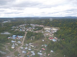
Fort Yukon is a city in the Yukon-Koyukuk Census Area in the U.S. state of Alaska, straddling the Arctic Circle. The population, predominantly Gwich'in Alaska Natives, was 583 at the 2010 census, down from 595 in 2000.

Rampart is a census-designated place (CDP) in Yukon-Koyukuk Census Area, Alaska, United States. The population was 24 at the 2010 census, down from 45 in 2000.

Tanana is a city in the Yukon-Koyukuk Census Area in the U.S. state of Alaska. At the 2010 census the population was 246, down from 308 in 2000. It was formerly known as Clachotin, adopted by Canadian French.
Ohagamiut is an abandoned village along the Kuskokwim River in the Bethel Census Area of the southwestern part of the U.S. state of Alaska, located between Crow Village and Kalskag. It was abandoned in the 1940s as residents relocated to Kalskag, Aniak, Bethel and other towns. The village site is located just 3 miles east of Upper Kalskag.
Georgetown is an unincorporated Alaska Native village located in the Bethel Census Area of the U.S. state of Alaska. The population as of the 2010 census was 2, down from 3 in 2000.

Southwest Alaska is a region of the U.S. state of Alaska. The area is not exactly defined by any governmental administrative region(s); nor does it always have a clear geographic boundary.

