
Alappuzha district, is one of the 14 districts in the Indian state of Kerala. It was formed as Alleppey district on 17 August 1957, the name of the district being changed to Alappuzha in 1990. Alappuzha is the smallest district of Kerala. Alleppey town, the district headquarters, was renamed Alappuzha in 2012, even though the anglicised name is still commonly used to describe the town as well as the district.

Ernakulam is one of the 14 districts in the Indian state of Kerala, and takes its name from the eponymous city division in Kochi. It is situated in the central part of the state, spans an area of about 2,924 square kilometres (1,129 sq mi), and is home to over 9% of Kerala's population. Its headquarters are located at Kakkanad. The district includes Kochi, also known as the commercial capital of Kerala, which is famous for its ancient churches, Hindu temples, synagogues and mosques.

Idukki is one of the 14 districts in the Indian state of Kerala in the southwest of the country. It is the largest district in Kerala and lies amid the Cardamom Hills of Western Ghats in Kerala. Idukki district contains two municipal towns – Kattappana and Thodupuzha, and five taluks.

Taliparamba is a Municipality in Taliparamba taluk of Kannur district, Kerala, India. The municipal town spreads over an area of 18.96 square kilometres (7.32 sq mi) and is inhabited by 44,247 number of people.
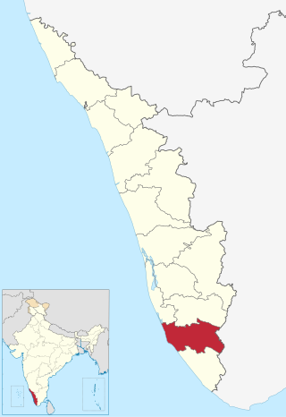
Kollam district, is one of 14 districts of the state of Kerala, India. The district has a cross-section of Kerala's natural attributes; it is endowed with a long coastline, a major Laccadive Sea seaport and an inland lake. The district has many water bodies. Kallada River is one among them, and land on the east bank of the river is East Kallada and that on the west bank is West Kallada.
Kothamangalam is a municipality at the foot of the Western Ghats in the Ernakulam district of Kerala, India. It is located 31 km (19.3 mi) east of the district collectorate in Thrikkakara and about 177 km (110.0 mi) north of the state capital Thiruvananthapuram. As per the 2011 Indian census, Kothamangalam has a population of 38,837 people, and a population density of 969/km2 (2,510/sq mi).
Feroke is a Municipality and a part of Kozhikode metropolitan area under Kozhikode Development Authority (K.D.A) in the Kozhikode district of the Indian state of Kerala.

Thrissur, anglicised as Trichur, is one of the 14 districts in the Indian state of Kerala. It is situated in the central region of the state. Spanning an area of about 3,032 km2 (1,171 sq mi), the district is home to over 9% of Kerala's population.

Ernakulam is the central business district of the city of Kochi, Kerala, India. It is the namesake of Ernakulam district. The eastern part of Kochi city is mainly known as Ernakulam, while the western part of it after the Venduruthy Bridge is called as Western Kochi. Many major establishments, including the Kerala High Court, the office of the Kochi Municipal Corporation and the Cochin Shipyard are situated in Ernakulam. It is also the most urbanized area in the city of Kochi.

Kottarakkara, also transliterated as Kottarakara, is a town and municipality in the Kollam district of the Kerala, India. Kottarakkara lies 27 kilometres (17 mi) to the east of Kollam city centre.

Ramanattukara is a municipality census town in Kozhikode district in the Indian state of Kerala. The town was formerly called Kadungan Chira village. Ramanattukara is located 15 km away from Kozhikode city.

Thiruvankulam is a census town and revenue village in Thrippunithura municipality, in Ernakulam district, Kerala, India. The area is a part of the Kochi metropolitan area. NH 85 passes through Thiruvankulam. The Karingachira junction is the location of the southern terminus of the Seaport-Airport Road, which connects the Cochin International Airport and the Cochin Port.

Kizhakkambalam is an eastern suburb of the city of Kochi in Ernakulam district, Kerala, India. It is regarded as a model panchayat for its various development activities and is a part of the Kunnathunad tehsil of the Ernakulam district.

Kadavoor is a small village in Paingottoor Gram panchayat in Kothamangalam Taluk at the eastern border of the Ernakulam district, state of Kerala, India. It is located about twenty kilometres away from the nearby towns Muvattupuzha, Kothamangalam and Thodupuzha.
Kallorkkad is a village in Ernakulam district, in the Indian state of Kerala. Most of its people are either farmers or engaged in small-scale business.
Kombanad is a village in Ernakulam district in the Indian state of Kerala.

Kuttampuzha is a village and gram panchayat in Ernakulam district in the Indian state of Kerala. Situated 71 km east of Kochi, Kuttampuzha panchayat is home to the 17.7% of total area of the Ernakulam District.

Aluva railway station is an NSG–3 category Indian railway station in Thiruvananthapuram railway division of Southern Railway zone. It is a railway station in the city of Aluva in the Ernakulam district in the Indian state of Kerala. The station lies in the Shoranur–Cochin Harbour section of Thiruvananthapuram railway division. It is located right aside Aluva KSRTC bus stand, one of the main bus terminals in Ernakulam district, and a kilometre away from Aluva metro station of the Kochi Metro.

Eranad Taluk comes under Perinthalmanna revenue division in Malappuram district of Kerala, India. Its headquarters is the city of Manjeri. Eranad Taluk contains two municipalities - Manjeri and Malappuram. Most of the administrative offices are located in the Civil Station at Malappuram and the Mini-Civil Station at Manjeri.


