Pakala, Chittoor district

Last updated

Pakala
Pakala Railway Station.JPG
Pakala railway station view from foot overbridge
India Andhra Pradesh location map (current).svg
Red pog.svg
Pakala
Location in Andhra Pradesh, India
India location map.svg
Red pog.svg
Pakala
Pakala (India)
Coordinates: 13°28′00″N79°07′00″E / 13.4667°N 79.1167°E / 13.4667; 79.1167 Coordinates: 13°28′00″N79°07′00″E / 13.4667°N 79.1167°E / 13.4667; 79.1167
CountryIndia
State Andhra Pradesh
District Tirupati
Mandal Pakala
Elevation
361 m (1,184 ft)
Languages
  Official Telugu
Time zone UTC+5:30 (IST)
Telephone code918585
Vehicle registration AP03 (Before 2019) / AP39 (2019)
Nearest city Tirupati
Sex ratio2:1 /
Lok Sabha constituencyChittoor
Vidhan Sabha constituencyChandragiri

Pakala is a major town in Tirupati district of the Indian state of Andhra Pradesh. It is the mandal headquarters of Pakala mandal. [1]

Contents

It comes under the political constituency of Chittoor.

About

Pakala is a mandal in Tirupati district of Andhra Pradesh, India. Pakala Mandal Headquarters is Pakala town. It belongs to Rayalaseema region. It is located 44 km towards West from District headquarters Tirupathi. 450 km from State capital Amaravathi .

Pakala Mandal is bounded by Puthalapattu Mandal towards South, Penumuru Mandal towards South, Pulicherla H/O Reddivaripalle Mandal towards North, Irala Mandal towards west. Chittoor City, Tirupati City, Puttur City, Renigunta City are the nearby cities to Pakala.

Pakala consists of 180 villages and 28 panchayats. Nagamma Agraharam is the smallest village and Pakala is the biggest village. It is in the 371 m elevation (altitude).

Chittoor, Tirupati (Tirumala), Vellore, Thiruthani, Srikalahasti are the nearby important tourist destinations to see.

Education

The primary and secondary school education is imparted by government, aided and private schools, under the School Education Department of the state.[2][3] The medium of instruction followed by different schools are English, Telugu and Urdu.

Colleges

Schools

Demographics

Telugu is the official and widely spoken language. Also people speak Urdu. Total population of Pakala Mandal is 56,802 living in 13,533 houses, Spread across total 180 villages and 28 panchayats. Males are 28,414 and females are 28,388

Geography

Pakala is located at 13°28′00″N79°07′00″E / 13.4667°N 79.1167°E / 13.4667; 79.1167 . [2] It has an average elevation of 361 meters (1184 feet).

Distance

Governance

Pakala(Chandragiri) is one of the 175 assembly constituencies of Andhra Pradesh Legislative Assembly, India. pakala is part of Chittoor (Lok Sabha constituency). N. Reddeppa of YSR Congress Party is the sitting Member of Parliament for Chittoor (Lok Sabha constituency) and Chevireddy Bhaskar Reddy of YSR Congress Party is Chandragiri the sitting Member of Legislative Assembly for Chandragiri (Assembly constituency).

Politics

Pakala is an Assembly constituency in Andhra Pradesh and the constituency number is 285.

Entertainment

There are two theaters in pakala town, Ramakrishna Theatre, Srinivas & Mini Theatre

Transport

Roadways

Pakala is well connected to major cities through national and state highways. The National Highways through Pakala Town are, National Highway 40 (India) connecting Pileru ,Madanapalli, Kadapa, Kurnool and Hyderabad on North and connecting Chittoor, Vellore and Chennai on South National Highway 69 (India) connecting Chittoor with Kolar and Bangalore on West National Highway 140 (India) connecting Chittoor with Tirupati and Nellore on East. The city has total road length of 382.30 km. [3]

Public transport

The Andhra Pradesh State Road Transport Corporation operates bus services from Chittoor bus station. [4] Bus services are operated to Chittoor, Tirupati, Madanapalli, Palamaner, Srikalahasti, Nellore, and also to all other major Panchayth and Villages in the Pakala, Chittoor District, Chittoor District, Andhra Pradesh.

Railways Chittoor railway station is a National railway station in Chittoor city of Andhra Pradesh. It lies on Gudur–Katpadi branch line section and is administered under Guntakal railway division of South Central Railway zone. Nearest major railway station is Tirupati, Andhra Pradesh, 45 km from Pakala Town. Katpadi Junction railway station, Tamil Nadu, is 70 km from Pakala Town.

Airports

The nearest domestic airport is Tirupati Airport at Renigunta in Chittoor district, Andhra Pradesh.

The nearest international airports are Chennai International Airport at Chennai and Kempegowda International Airport at Bangalore.

Climate

Climate data for Chittoor, Andhra Pradesh
MonthJanFebMarAprMayJunJulAugSepOctNovDecYear
Average high °C (°F)28.7
(83.7)
31.4
(88.5)
34.4
(93.9)
36.4
(97.5)
40.0
(104.0)
35.5
(95.9)
33.5
(92.3)
33.3
(91.9)
32.8
(91.0)
31.1
(88.0)
28.8
(83.8)
27.6
(81.7)
32.8
(91.0)
Average low °C (°F)17.7
(63.9)
18.8
(65.8)
21.2
(70.2)
24.5
(76.1)
26.2
(79.2)
25.7
(78.3)
24.6
(76.3)
24.4
(75.9)
23.8
(74.8)
22.5
(72.5)
20.2
(68.4)
18.1
(64.6)
22.3
(72.2)
Average rainfall mm (inches)6
(0.2)
6
(0.2)
8
(0.3)
24
(0.9)
58
(2.3)
72
(2.8)
102
(4.0)
115
(4.5)
145
(5.7)
162
(6.4)
110
(4.3)
54
(2.1)
862
(33.7)
Source: Climate-Data.org [5]

Villages Under Pakala Mandal

List of all towns and Villages in Pakala Mandal of Chittoor district, Andhra Pradesh. Complete details of Population, Religion, Literacy and Sex Ratio in tabular format. us 2011

Home Andhra Pradesh District List Tirupati District Pakala Mandal

List of all towns and Villages in Pakala Mandal of Tirupati district, Andhra Pradesh. Complete details of Population, Religion, Literacy and Sex Ratio in tabular format.

Landmarks

The Swayambu Varasidhi Vinayakaswamy temple [ permanent dead link ] at Kanipakam is the famous notable Hindu temple near the city.

The 11th century historical Chandragiri Fort is the notable landmark near the city.

From Pakala Town we have NARL National Atmosphere and Research Laboratory towards Tirupati 5 km from town

Related Research Articles

Chittoor City in Andhra Pradesh, India

Chittoor is a city and district headquarters in Chittoor district of the Indian state of Andhra Pradesh. It is also the mandal and divisional headquarters of Chittoor mandal and Chittoor revenue division, respectively. The city has a population of 153,756 and that of the agglomeration is 175,647.

Madanapalle City in Andhra Pradesh, India

Madanapalle is a city in Annamayya district of the Indian state of Andhra Pradesh. It is a Selection Grade Municipal City Council and the headquarters of Madanapalle mandal, Madanapalle revenue division and PKM Urban Development Authority.

Katpadi is a locality in Vellore, at the northern part of Vellore city in the state of Tamil Nadu, India. Its railway is located on the gauge line between Chennai-Bangalore and Villupuram-Tirupati.

Tirupati City in Andhra Pradesh, India

Tirupati is a city in the Indian state of Andhra Pradesh. It is the administrative headquarters of the Tirupati district. Located 415 km (258 mi) southwest of state's capital Amaravati, the city is home to the important Hindu shrine of Tirumala Venkateswara Temple and other historic temples and is referred to as the "Spiritual Capital of Andhra Pradesh". It is one of the eight Swayam vyaktha kshetras dedicated to Lord Vishnu. Tirupati is a municipal corporation and the headquarters of Tirupati (urban) mandal, Tirupati (rural) mandal, and the Tirupati revenue division.

Chittoor district District of Andhra Pradesh in India

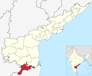
Chittoor district, is one of the eight districts in the Rayalaseema region of the Indian state of Andhra Pradesh. The district headquarters is located at Chittoor. It has a population of 4,170,468 according to 2011 census of India. Chittoor district has many major temples including Kanipakam, and other temples. It lies in the Poini river valley of southernmost Andhra Pradesh along the Chennai – Bangalore section of Chennai-Mumbai highway. Chittoor district is a major market centre for mangoes, grains, sugarcane, and peanuts.

Rajampet Municipality in Andhra Pradesh, India

Rajampet is a Municipality in Annamayya Rajampeta District of the Indian state of Andhra Pradesh, located in the Rayalaseema Region. The town has an average elevation of 139 meters (456 ft). Rajampet was a Nagar panchayat and upgraded as a Grade II Municipality in 2019 and has an area of 35.38 square kilometres (13.66 sq mi). It consists of 20 election wards.

Kadiri is a major city in the Newly Formed Sri Sathya Sai District of the Indian state of Andhra Pradesh. It is a Special Grade Municipal City Council and headquarters of Kadiri Mandal and Kadiri Revenue Division. Kadiri Taluka ('Tehsil') was the largest taluk in the state of Andhra Pradesh when there was taluka system in Andhra Pradesh Kadiri is known for its jasmine and saffron flowers. Kadiri saffron is widely sold in Andhra and Karnataka. The Sri Lakshmi Narasimhaswamy Temple is reminiscent of Kadiri to the people of Karnataka, Telangana And Tamil Nadu. The name of Kadiri has also some interesting past. The habitation was initially named as Khadripuram as ‘khadara’ plants were largely found in the surrounding forests and Khadri has later transformed as Kadiri.

Srikalahasti Town in Andhra Pradesh, India

Srikalahasti is a holy city in Tirupati district of the Indian state of Andhra Pradesh. It is a municipality and the mandal headquarters of Srikalahasti mandal. The city is a part of Tirupati Urban Development Authority, which is located on the banks of the River Swarnamukhi.

Railway Koduru Town in Andhra Pradesh, India

Railway Koduru is a town in YSR Kadapa district of the Indian state of Andhra Pradesh. It is located in the Rajampet revenue division of YSR Kadapa district.

Sri City or Satyavedu Reserve Infracity Pvt. Ltd. is an integrated business city (township) located on NH 16 in the state of Andhra Pradesh, India. Sri City forms part of Satyavedu and Varadaiahpalem mandals of Tirupati District. Sri City is located in Tirupati district along the NH16 of Andhra Pradesh, India.

Chandragiri Assembly constituency is a constituency of Andhra Pradesh Legislative Assembly, India. It is one among 14 constituencies in Chittoor district.

Pulicherla mandal is one of the 66 mandals in Chittoor district of the Indian state of Andhra Pradesh.

Chandragiri mandal is one of the 34 mandals in Tirupati district of the Indian state of Andhra Pradesh. It is under the administration of Tirupati revenue division and the headquarters are located at Chandragiri. The mandal is bounded by Chinnagottigallu, Pulicherla, Ramachandrapuram, Pakala, Penumuru, Vedurukuppam, Tirupati (urban) and Tirupati (rural) mandals.

Srikalahasti mandal is one of the 33 mandals in Tirupati district of the Indian state of Andhra Pradesh. It is under the administration of Tirupati revenue division and the headquarters are located at Srikalahasti. The mandal is bounded by Renigunta, Yerpedu, Narayanavanam and Thottambedus.

Chemuru Village in Andhra Pradesh, India

Chemuru is a village in Thottambedu mandal, located in Chittoor district of Indian state of Andhra Pradesh. This belongs to Chiyyavaram Gram panchayat, Srikalahasti assembly constituency and Tirupati parliamentary constituency

Gudur–Katpadi section

Gudur–Katpadi branch line connects Gudur of Andhra Pradesh town with Katpadi of Tamil Nadu City. This entire line is under the jurisdiction of Guntakal railway division. It is an electrified railway section

Chandragiri railway station is an Indian Railway station in Chandragiri of Chittoor district in Andhra Pradesh. It is situated on Renigunta–Katpadi section and is administered by Chittoor railway division of South Coast Railway zone.

Nadimpalli, Chittoor Village in Andhra Pradesh, India

Nadimpalli is a remote rural village in Puthalapattu mandal of Chittoor district in Andhra Pradesh.

Tirupati district is a district in the Indian state of Andhra Pradesh. With Tirupati as its administrative headquarters, it was proposed on 26 January 2022 and started functioning from 4 April 2022 to become one of the resultant twenty-six districts in the state after a final notification was issued by the government of Andhra Pradesh. The district was formed from Tirupati revenue division from Chittoor district and Gudur and Naidupeta revenue divisions of Nellore district.

References

  1. "Chittoor District Mandals" (PDF). Census of India. pp. 472, 514. Retrieved 19 June 2015.
  2. "Maps, Weather, and Airports for Pakala, India". fallingrain.com.
  3. "DETAILS OF ROADS IN EACH ULB OF ANDHRA PRADESH". Archived from the original on 1 August 2016.
  4. "Bus Stations in Districts". Andhra Pradesh State Road Transport Corporation. Archived from the original on 22 March 2016. Retrieved 9 March 2016.
  5. "CLIMATE: CHITTOOR" . Retrieved 19 February 2016.