Tirupati (rural) mandal

Last updated

Tirupati (rural) mandal
India Andhra Pradesh location map (current).svg
Red pog.svg
Tirupati (rural) mandal
Location in Andhra Pradesh, India
India location map.svg
Red pog.svg
Tirupati (rural) mandal
Tirupati (rural) mandal (India)
Coordinates: 13°33′50″N79°22′58″E / 13.56389°N 79.38278°E / 13.56389; 79.38278
CountryFlag of India.svg  India
State Andhra Pradesh
District Tirupati
Headquarters Tirupati
Government
   MLA bhumana karunakar Reddy (YSRCP)
   MP Dr.M.Gurumoorthy
Area
[1] :3
   Mandal 112 km2 (43 sq mi)
Population
 (2011) [1] :XXIX,7
   Mandal 117,445
  Density1,000/km2 (2,700/sq mi)
   Urban
66,974
   Rural
50,471
Languages
  Official Telugu
Time zone UTC+05:30 (IST)

Tirupati (rural) mandal is one of the 34 mandals in Tirupati district of Andhra Pradesh in India. It is under the administration of Tirupati revenue division and the headquarters are located at Tirupati.

Contents

History

The mandal was a part of Chittoor district and was made a part of the newly formed Tirupati district on 4 April 2022 as part of reorganisation of the districts in the state by the Y. S. Jagan Mohan Reddy-led Government of Andhra Pradesh. [2]

Geography

The mandal is bounded by Chandragiri mandal, Ramachandrapuram mandal, Renigunta mandal, Tirupati (urban) mandal and Vadamalapeta mandal. [3]

Demographics

Religions in Tirupati (rural) mandal (2011)
ReligionPercent
Hindus
95.71%
Muslims
3.45%
Christians
0.56%
Others or not stated
0.28%
Distribution of religions [1] :30,32,34

As per 2011 census, the mandal had a total population of 117,445 with 59,449 male population and 57,996 female population with a density of 1,049/km2. It had a sex ratio of 976. Scheduled Castes and Scheduled Tribes made up 18,934 and 3,933 of the population respectively. It had a literacy rate of 75.74% with 82.62% among males and 68.72% among females. [1] :XXIX,XXXIII,3,5

Administration

The mandal is a part of the Tirupati revenue division. [2] The headquarters are located at Tirupati. [3] As of 2011 census, the mandal comprises the following villages:

  1. Avilala
  2. Brahmana Pattu
  3. C.Mallavaram
  4. Cherlopalle
  5. Chiguruwada
  6. Durga Samudram
  7. Gandhipuram
  8. Gollapalle
  9. Kuntrapakam
  10. Kupu Chandrapeta
  11. Lingeshwar Nagar
  12. Mallam Gunta
  13. Mangalam
  14. Mundlapudi
  15. Oteru
  16. Padipeta
  17. Padhmavathipuram
  18. Paidipalle
  19. Patha Kalva
  20. Perumallapalle
  21. Perur
  22. Pudipatla
  23. Ramanujapalle
  24. Ranadheerpuram
  25. Sainagar
  26. Sapthagiri Colony
  27. Settipalle
  28. Srinivasapuram
  29. Thanapalle
  30. Thummala Gunta
  31. Tiruchanur
  32. Tirumala Nagar
  33. Vedanthapuram
  34. Venkatapathi Nagar

Politics

The mandal is one of the 7 mandals under Chandragiri Assembly constituency, which in turn is a part of Chittoor Lok Sabha constituency of Andhra Pradesh. As of 1 January 2018, the mandal has 92,775 eligible voters with 46,173 male and 46,602 female voters. [6] :XXXIII Chevireddy Bhaskar Reddy is representing the Chandragiri constituency as the Member of the Legislative Assembly (MLA) in Andhra Pradesh Legislative Assembly, [7] and N. Reddeppa is representing the Chittoor constituency as the Member of Parliament (MP) in Lok Sabha. [8]

Related Research Articles

<span class="mw-page-title-main">Chittoor</span> City in Andhra Pradesh, India

Chittoor is a city and district headquarters in Chittoor district of the Indian state of Andhra Pradesh. It is also the mandal and divisional headquarters of Chittoor mandal and Chittoor revenue division respectively. The city has a population of 153,756 and that of the agglomeration is 175,647.

<span class="mw-page-title-main">Chittoor district</span> District of Andhra Pradesh in India

Chittoor district is one of the eight districts in the Rayalaseema region of the Indian state of Andhra Pradesh. The district headquarters is located at Chittoor. It has a population of 18,72,951 according to 2011 census of India. Chittoor district is a major market centre for mangoes, grains, sugarcane, and peanuts. Map

<span class="mw-page-title-main">Pakala, Tirupati district</span> Town in Andhra Pradesh, India

Pakala is a town in Tirupati district of the Indian state of Andhra Pradesh. It is the mandal headquarters of Pakala mandal. It comes under Tirupati revenue division.

Ramachandrapuram mandal is one of the 34 mandals in Tirupati district of the Indian state of Andhra Pradesh. It is under the administration of Tirupati revenue division and the headquarters are located at Kammapalle.

Srirangarajapuram is a mandal in Chittoor district of the Indian state of Andhra Pradesh. It is the mandal headquarters of Srirangarajapuram mandal.

Venkatagiri Assembly constituency is a constituency of the Andhra Pradesh Legislative Assembly, India. It is one of the 7 constituencies in Tirupati district.

Chandragiri Assembly constituency is a constituency of Andhra Pradesh Legislative Assembly, India. It is one among 7 constituencies in Tirupati district.

Srikalahasti Assembly constituency is a constituency of Andhra Pradesh Legislative Assembly, India. It is one among 7 constituencies in Tirupati district.

Chandragiri mandal is one of the 34 mandals in Tirupati district of the Indian state of Andhra Pradesh. It is under the administration of Tirupati revenue division and the headquarters are located at Chandragiri.

Srikalahasti mandal is one of the 34 mandals in Tirupati district of the Indian state of Andhra Pradesh. It is under the administration of Srikalahasti revenue division and the headquarters are located at Srikalahasti. The mandal is bounded by Renigunta, Yerpedu, Narayanavanam and Thottambedus. The mandal was a part of Chittoor district and was reorganised to be a part of newly formed Tirupati district on 4 April 2022.

<span class="mw-page-title-main">Tirupati district</span> District in Andhra Pradesh, India

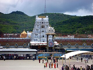
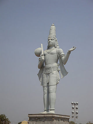
Tirupati district is one of the eight districts of Rayalaseema region in the Indian state of Andhra Pradesh. The district headquarters is located at Tirupati city. This district is known for its numerous historic temples, including the Hindu shrine of Tirumala Venkateswara Temple, Sri Kalahasteeswara temple. The district is also home to Satish Dhawan Space Centre, a rocket launch centre located in Sriharikota and operated by Indian Space Research Organisation (ISRO). The river Swarnamukhi flows through Tirupati, Srikalahasti and joins the Bay of Bengal.

<span class="mw-page-title-main">Annamayya district</span> District in Andhra Pradesh in India created in 2022

Annamayya district is one of the eight districts in the Rayalaseema region of Andhra Pradesh, established in 2022. Rayachoti is the district administrative headquarters and Madanapalle is the most populated town in the district.

Pakala mandal is one of the 34 mandals in Tirupati district of the Indian state of Andhra Pradesh. It is under the administration of Tirupati revenue division and the headquarters are located at Pakala.

Vakadu mandal is one of the 34 mandals in Tirupati district in the Indian state of Andhra Pradesh. It is a part of Gudur revenue division.

Venkatagiri mandal is one of the 34 mandals in Tirupati district in the Indian state of Andhra Pradesh. It is a part of Gudur revenue division.

Doravarisatram mandal is one of the 34 mandals in Tirupati district in the Indian state of Andhra Pradesh. It is a part of Sullurupeta revenue division.

Chillakur mandal is one of the 34 mandals in Tirupati district in the Indian state of Andhra Pradesh. It is a part of Gudur revenue division and is headquartered at Chillakur.

Chittamur mandal is one of the 34 mandals in Tirupati district in the Indian state of Andhra Pradesh. It is a part of Gudur revenue division with its headquarters at Chittamur.

Narayanavanam mandal is one of the 34 mandals in Tirupati district in the Indian state of Andhra Pradesh. It is administered as a part of Srikalahasti revenue division.

Chinnagottigallu mandal is one of the 34 mandals in Tirupati district in the Indian state of Andhra Pradesh. It is a part of Tirupati revenue division with its headquarters at Chinnagottigallu.

References

  1. 1 2 3 4 Hand book of Statistics Chittoor district 2018 (PDF) (Report). 2018. pp. XXIX, XXXIII, 3, 5, 7, 30, 32, 34, 62. Retrieved 24 September 2022.
  2. 1 2 Sasidhar, B. M. (4 April 2022). "Chittoor, Tirupati, Annamayya districts formed as part of rejig". The Hans India. Retrieved 7 April 2022.
  3. 1 2 "Part-III District and Sub-district [Mandals] Guntur to Chittoor [7 Districts]" (PDF). Census of India. 2011. p. 451. Archived from the original (PDF) on 23 February 2022. Retrieved 24 September 2022.
  4. "Sub-District Details of East Godavari District". censusindia.gov.in. Archived from the original on 13 September 2014. Retrieved 13 September 2014.
  5. "Tirupati (rural) mandal villages" (PDF). apland.ap.nic.in. Archived from the original (PDF) on 14 December 2014. Retrieved 13 September 2014.
  6. Hand book of Statistics Chittoor district 2018 (PDF) (Report). 2018. pp. XXXIII, 3, 5, 30, 32, 34, 62. Retrieved 24 September 2022.
  7. "Andhra Pradesh Assembly election result: Full list of winners". Financial Express . 24 May 2019. Retrieved 25 September 2022.
  8. A. D. Rangarajan (24 May 2019). "Crushing defeat for TDP in Naidu's home turf of Chittoor". The Hindu . ISSN   0971-751X . Retrieved 25 September 2022.