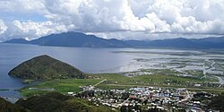
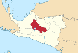
Paniai Regency is one of the regencies (kabupaten) in Central Papua Province of Indonesia. It is named after the Paniai Lakes. It covers an area of 6,525.25 km2, and had a population of 153,432 at the 2010 Census[2] and 220,410 at the 2020 Census;[3] the official estimate as of mid-2024 was 227,254 - comprising 124,260 males and 102,994 females.[1] The administrative centre is the town of Enarotali, in East Paniai.
At the 2010 Census, Paniai Regency comprised ten districts (distrik). However, by 2018 the splitting of existing districts to create additional ones had raised the total to twenty-four districts. These are tabulated below with their areas and their populations at the 2010 census[2] and 2020 Census.[3] The table also includes the locations of the district administrative centres, the number of administrative villages in each district (totaling 216 rural kampung and 5 urban kelurahan), and its post code.
Kode Wilayah
Name of District (distrik)
Area in km2
Pop'n 2010 census
Pop'n 2020 census
Admin centre
No. of villages
Post code
94.03.01
Paniai Timur (East Paniai)
588.80
32,864
13,581
Enarotali
26 (a)
98711 -98714
94.03.09
Yatamo
130.84
14,435
5,727
Wotai
5
98726
94.03.08
Kebo
359.82
19,017
5,391
Kebo I
13
98715
94.03.13
Pugo Dagi
(b)
(b)
2,676
Pugo
9
98719
94.03.11
Wegee Muka
(b)
(b)
16,310
Badawo
11 (c)
98717
94.03.12
Wegee Bino
(b)
(b)
9,740
Dei
9
98716
94.03.17
Yagai
(b)
(b)
7,930
Panibagata
10
98718
94.03.20
Deiyai Miyo
(b)
(b)
2,899
Deiyamo
6
98725
94.03.05
Bibida
450.00
1,781
7,337
Bibida
7 (c)
98741
94.03.06
Dumadama
1,404.00
4,860
4,750
Duma
5
98743
94.03.21
Dogomo
(b)
(b)
6,542
Dogomo
5
98742
94.03.03
Aradide
262.67
13,045
13,161
Abatadi
9
98731
94.03.10
Ekadide
187.62
20,734
17,416
Pasir Putih
12
98733
94.03.22
Aweida
(b)
(b)
1,936
Deta
6
98732
94.03.24
Fajar Timur (East Fajar)
(b)
(b)
5,268
Dauwagu
7
98731 -98732
94.03.23
Topiyai
(b)
(b)
10,080
Obaipugaida
10
98734
94.03.02
Paniai Barat (West Paniai)
1,314.58
28,877
13,522
Obano
13 (c)
98723
94.03.07
Siriwo
1,307.00
6,364
16,203
Siriwo
14
98724
94.03.14
Muye
(b)
(b)
2,098
Muyetadi
10
98721
94.03.15
Nakama
(b)
(b)
8,685
Okaitadi
7
98722
95.03.16
Teluk Deya (Deya Bay)
(b)
(b)
10,643
Ukauwo
6
98727
94.03.04
Bogobaida
130.84
11,455
11,718
Bogobaida
9
98736
94.03.18
Youtadi
(b)
(b)
10,186
Youtadi
6
98737
94.03.19
Baya Biru
(b)
(b)
16,611
Bayabiru
6
98735
Totals
Note (a) including two kelurahan - the towns of Enarotali and Timida. (b) The fourteen new districts created since 2013 are: Aweida, Baya Biru, Deiyai Miyo, Dogomo, Fajar Timur (East Fajar), Muye, Nakama, Pugo Dagi, Teluk Deya (Deya Bay), Topiyai, Wege Bino, Wege Muka, Yagai and Youtadi. Their areas and populations as at 2010 are included with the figures for the original districts from which they were cut out subsequently. (c) including one kelurahan - the district admin centre.
References
1 2 3 Badan Pusat Statistik, Jakarta, 28 February 2024, Kabupaten Paniai Dalam Angka 2024 (Katalog-BPS 1102001.9605)
This page is based on this Wikipedia article Text is available under the CC BY-SA 4.0 license; additional terms may apply. Images, videos and audio are available under their respective licenses.